
Washington County is a county in the U.S. state of Indiana. As of the 2020 United States Census, the population was 28,182. The county seat is Salem.

Harrison County is located in the far southern part of the U.S. state of Indiana along the Ohio River. The county was officially established in 1808. Its population was 39,654 as of the 2020 United States Census. Its county seat is Corydon, the former capital of Indiana.

Connersville is a city in Fayette County, east central Indiana, United States, 66 miles (106 km) east by southeast of Indianapolis. The population was 13,481 at the 2010 census. The city is the county seat of and the largest and only incorporated town in Fayette County. The city is in the center of a large rural area of east central Indiana; the nearest significant city is Richmond, 26 miles (42 km) to the northeast by road. Connersville is home to the county's only high school. The local economy relies on manufacturing, retail, and healthcare to sustain itself. However, there has been a consistent decline in both employment and population since the 1960s, placing it among the least affluent areas in the state, as indicated by measures such as median household income and other economic indicators.

Corydon is a town in Harrison Township, Harrison County, Indiana. Located north of the Ohio River in the extreme southern part of the U.S. state of Indiana, it is the seat of government for Harrison County. Corydon was founded in 1808 and served as the capital of the Indiana Territory from 1813 to 1816. It was the site of Indiana's first constitutional convention, which was held June 10–29, 1816. Forty-three delegates convened to consider statehood for Indiana and drafted its first state constitution. Under Article XI, Section 11, of the Indiana 1816 constitution, Corydon was designated as the capital of the state, which it remained until 1825, when the seat of state government was moved to Indianapolis. In 1863, during the American Civil War, Corydon was the site of the Battle of Corydon, the only official pitched battle waged in Indiana during the war. More recently, the town's numerous historic sites have helped it become a tourist destination. A portion of its downtown area is listed in the National Register of Historic Places as the Corydon Historic District. As of the 2010 census, Corydon had a population of 3,122.

Laconia is a town in Boone Township, Harrison County, Indiana, United States. The population was 50 at the 2010 census.

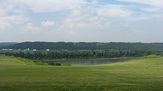
Mauckport is a town in Heth Township, Harrison County, Indiana, along the Ohio River. The population was 81 at the 2010 census.

Wappinger is a town in Dutchess County, New York, United States. The town is located in the Hudson River Valley region, on the eastern bank of the Hudson River. The population was 28,216 at the 2020 census. The name is derived from the Wappinger Native Americans who inhabited the area. Wappinger comprises three-fourths of the incorporated village of Wappingers Falls, several unincorporated hamlets such as Chelsea, Diddell, Hughsonville, Middlebush, Myers Corners, New Hackensack, and Swartwoutville, and a number of neighborhoods.

The Battle of Corydon was a minor engagement that took place July 9, 1863, just south of Corydon, which had been the original capital of Indiana until 1825, and was the county seat of Harrison County. The attack occurred during Morgan's Raid in the American Civil War as a force of 2,500 cavalry invaded the North in support of the Tullahoma Campaign. It was the only pitched battle of the Civil War that occurred in Indiana, and no battle has occurred within Indiana since.

Redland, long known also as the Redlands or the Redland, is a historic unincorporated community and agricultural area in Miami-Dade County, Florida, located about 20 miles (32 km) southwest of downtown Miami and just northwest of Homestead, Florida. It is unique in that it constitutes a large farming belt directly adjoining what is now the seventh most populous major metropolitan area in the United States. Named for the pockets of red clay that cover a layer of oolitic limestone, Redland produces a variety of tropical fruits, many of which do not grow elsewhere in the continental United States. The area also contains a large concentration of ornamental nurseries. The landscape is dotted with u-pick'em fields, coral rock (oolite) walls, and the original clapboard homes of early settlers and other historic early twentieth century structures.

The Corydon Historic District is a national historic district located in Corydon, Indiana, United States. The town of Corydon is also known as Indiana's First State Capital and as Historic Corydon. The district was added to the National Register of Historic Places in 1973, but the listing was amended in 1988 to expand the district's geographical boundaries and include additional sites. The district includes numerous historical structures, most notably the Old Capitol, the Old Treasury Building, Governor Hendricks' Headquarters, the Constitution Elm Memorial, the Posey House, the Kintner-McGrain House, and The Kintner House Inn, as well as other residential and commercial sites.

Canaan is an unincorporated community and census-designated place (CDP) in Shelby Township, Jefferson County, Indiana, United States. As of the 2010 census it had a population of 90.

Strother Madison Stockslager was an American lawyer, Civil War veteran, and politician who served two terms as a U.S. Representative from Indiana from 1881 to 1885.

Harrison Township is one of twelve townships in Harrison County, Indiana, United States. As of the 2010 census, its population was 12,484 and it contained 5,282 housing units. Corydon, the county seat of Harrison County, is in Harrison Township.
Heth Township is one of twelve townships in Harrison County, Indiana, United States. As of the 2010 census, its population was 1,278 and it contained 573 housing units.
Bryantsburg is an unincorporated community in Monroe Township, Jefferson County, Indiana.
Lancaster is an unincorporated community in Lancaster Township, Jefferson County, Indiana.

Glidas is an unincorporated community in the Heth Township of Harrison County, Indiana, United States. The community is concentrated around the intersection of Glidas Road SW and Hillcrest Drive, just off State Road 135 between Mauckport and Corydon. In earlier days, the community was an advance trading post for Mauckport where farm stores were collected for export on the Ohio River.
Harvey Heth (1770–1816) was born on April 28, 1770, in Virginia. He was the son of Agnes McMahon Heth and Captain Henry Heth, a new Irish immigrant to the United States and a veteran of the American Revolutionary War. He was also the brother of several other Revolutionary War veterans, including Henry Heth.
Corydon Central High School is a public high school located in Corydon, Indiana. The school is part of the South Harrison Community School System. The school serves high school age students of Harrison Township, Washington Township, Heth Township, and Webster Township. It is the largest school in Harrison County.
Paul and Susannah Mitchem were a couple from Virginia who owned dozens of slaves; late in their life they decided to bring their slaves to Harrison County, Indiana and free them. They also used the Meachum surname. The Mitchems emancipated over 100 enslaved people in Indiana, most of whom settled around Corydon, Indiana. Farms, businesses, churches, and schools were established by and for the African American community, often called the Mitchem Settlement.


