New Middletown, Indiana

Last updated

New Middletown, Indiana
New-Middletown-in.jpg
New Middletown
Harrison County Indiana Incorporated and Unincorporated areas New Middletown Highlighted 1853298.svg
Location of New Middletown in Harrison County, Indiana.
Coordinates: 38°9′49″N86°3′2″W / 38.16361°N 86.05056°W / 38.16361; -86.05056
Country United States
State Indiana
County Harrison
Township Webster
Area
[1]
  Total0.04 sq mi (0.09 km2)
  Land0.04 sq mi (0.09 km2)
  Water0.00 sq mi (0.00 km2)
Elevation
[2]
699 ft (213 m)
Population
 (2020)
  Total90
  Density2,571.43/sq mi (995.64/km2)
Time zone UTC-5 (Eastern (EST))
  Summer (DST) UTC-4 (EDT)
ZIP code
47160
Area code 812
FIPS code 18-53298 [3]
GNIS feature ID0440086 [2]

New Middletown is a town in Webster Township, Harrison County, Indiana, United States. The population was 93 at the 2010 census.

Contents

History

New Middletown was laid out in 1860. [4]

Geography

New Middletown is located at 38°9′49″N86°3′2″W / 38.16361°N 86.05056°W / 38.16361; -86.05056 (38.163481, -86.050667). [5] The town is situated in a hilly area of central Harrison County, southeast of Corydon and northwest of Elizabeth.

According to the 2010 census, New Middletown has a total area of 0.04 square miles (0.10 km2), all land. [6]

Demographics

Historical population
CensusPop.Note
1880 171
1890 21224.0%
1900 167−21.2%
1910 145−13.2%
1920 119−17.9%
1930 118−0.8%
1940 115−2.5%
1950 15333.0%
1960 132−13.7%
1970 1330.8%
1980 115−13.5%
1990 82−28.7%
2000 77−6.1%
2010 9320.8%
2020 90−3.2%
U.S. Decennial Census [7]

2010 census

As of the census [8] of 2010, there were 93 people, 32 households, and 24 families living in the town. The population density was 2,325.0 inhabitants per square mile (897.7/km2). There were 39 housing units at an average density of 975.0 per square mile (376.4/km2). The racial makeup of the town was 95.7% White, 2.2% African American, and 2.2% from two or more races.

There were 32 households, of which 46.9% had children under the age of 18 living with them, 46.9% were married couples living together, 12.5% had a female householder with no husband present, 15.6% had a male householder with no wife present, and 25.0% were non-families. 25.0% of all households were made up of individuals. The average household size was 2.91 and the average family size was 3.17.

The median age in the town was 29.5 years. 29% of residents were under the age of 18; 15.2% were between the ages of 18 and 24; 17.2% were from 25 to 44; 31.3% were from 45 to 64; and 7.5% were 65 years of age or older. The gender makeup of the town was 54.8% male and 45.2% female.

2000 census

As of the census [3] of 2000, there were 77 people, 30 households, and 18 families living in the town. The population density was 1,833.9 inhabitants per square mile (708.1/km2). There were 35 housing units at an average density of 833.6 per square mile (321.9/km2). The racial makeup of the town was 96.10% White. Hispanic or Latino of any race were 3.90% of the population.

There were 30 households, out of which 30.0% had children under the age of 18 living with them, 53.3% were married couples living together, 3.3% had a female householder with no husband present, and 36.7% were non-families. 23.3% of all households were made up of individuals, and 10.0% had someone living alone who was 65 years of age or older. The average household size was 2.57 and the average family size was 3.05.

In the town, the population was spread out, with 22.1% under the age of 18, 11.7% from 18 to 24, 33.8% from 25 to 44, 23.4% from 45 to 64, and 9.1% who were 65 years of age or older. The median age was 37 years. For every 100 females, there were 102.6 males. For every 100 females age 18 and over, there were 100.0 males.

The median income for a household in the town was $45,000, and the median income for a family was $45,833. Males had a median income of $33,750 versus $17,500 for females. The per capita income for the town was $33,423. There were no families and 6.3% of the population living below the poverty line, including no under eighteens and 100.0% of those over 64.

Related Research Articles

<span class="mw-page-title-main">Monroe, Adams County, Indiana</span> Town in Indiana, United States

Monroe is a town in Washington and Monroe townships, Adams County, Indiana, United States. The population of the town was 945 residents at the 2019 census. Adams Central Community Schools is located in Monroe.

<span class="mw-page-title-main">Jonesville, Indiana</span> Town in Indiana, United States

Jonesville is a town in Wayne Township, Bartholomew County, in the U.S. state of Indiana. The population was 177 at the 2010 census. It is part of the Columbus, Indiana metropolitan statistical area.

<span class="mw-page-title-main">Flora, Indiana</span> Town in Indiana, United States

Flora is a town in Monroe Township, Carroll County, Indiana, United States. The population was 2,036 at the 2010 census. It is part of the Lafayette, Indiana Metropolitan Statistical Area.

<span class="mw-page-title-main">Onward, Indiana</span> Town in Indiana, United States

Onward is a town in Tipton Township, Cass County, Indiana, United States. The population was 100 at the 2010 census.

<span class="mw-page-title-main">Michigantown, Indiana</span> Town in Indiana, United States

Michigantown is a town in Michigan Township, Clinton County, Indiana, United States. The population was 467 at the 2010 census. The town was named for the Michigan Road, an early thoroughfare through the area.

<span class="mw-page-title-main">Milltown, Indiana</span> Town in Indiana, United States

Milltown is a town in Whiskey Run Township in Crawford County, Indiana and in Blue River and Spencer townships in Harrison County. The population was 818 at the time of the 2010 census.

<span class="mw-page-title-main">Shirley, Indiana</span> Town in Indiana, United States

Shirley is a town in Brown Township, Hancock County and Greensboro Township, Henry County, Indiana, United States. The population was 830 at the 2010 census.

<span class="mw-page-title-main">Lanesville, Indiana</span> Town in Indiana, United States

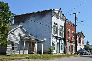
Lanesville is a town in Franklin Township, Harrison County, Indiana, United States. The population was 935 at the 2010 census.

<span class="mw-page-title-main">Middletown, Indiana</span> Town in Indiana, United States

Middletown is a town in northwest Henry County, Indiana, United States. The population was 2,322 at the 2010 census.

<span class="mw-page-title-main">Wheatland, Indiana</span> Town in Indiana, United States

Wheatland is a town in Steen Township, Knox County, Indiana, United States. The population was 480 at the 2010 census.

<span class="mw-page-title-main">Silver Lake, Indiana</span> Town in Indiana, United States

Silver Lake is a town in Lake Township, Kosciusko County, in the U.S. state of Indiana. The population was 915 at the 2010 census.

<span class="mw-page-title-main">Kingsbury, Indiana</span> Town in Indiana, United States

Kingsbury is a town in Washington Township, LaPorte County, Indiana, just northwest of the intersection of U.S. Route 35 and U.S. Route 6. The town was founded in 1835 and incorporated on March 3, 1941. During 1940 - 1941, the Kingsbury Ordnance Plant (KOP) was built for use during World War II. The plant closed after the war but reopened during the Korean War, closing permanently in 1959. The population was 242 at the 2010 census. It is included in the Michigan City, Indiana-La Porte, Indiana Metropolitan Statistical Area. The town has its own fire department, KVFD, and a Greek revival style First Baptist church built in 1851 with its own graveyard and Winchell Cemetery.

<span class="mw-page-title-main">Brook, Indiana</span> Town in Indiana, United States

Brook is a town in Iroquois Township, Newton County, in the U.S. state of Indiana. The population was 997 at the 2010 census.

<span class="mw-page-title-main">Roachdale, Indiana</span> Town in Indiana, United States

Roachdale is a town in Franklin and Jackson townships, Putnam County, in the U.S. state of Indiana. The population was 926 at the 2010 census.

<span class="mw-page-title-main">Saratoga, Indiana</span> Town in Indiana, United States

Saratoga is a town in Ward Township, Randolph County, in the U.S. state of Indiana. The population was 254 at the 2010 census.

<span class="mw-page-title-main">Lagro, Indiana</span> Town in Indiana, United States

Lagro is a town in Lagro Township, Wabash County, in the U.S. state of Indiana. The population was 415 at the 2010 census.

<span class="mw-page-title-main">North Middletown, Kentucky</span> City in Kentucky, United States

North Middletown is a home rule-class city in Bourbon County, Kentucky, in the United States. The population was 643 as of the 2010 census. North Middletown is part of the Lexington-Fayette Metropolitan Statistical Area.

<span class="mw-page-title-main">Middletown, Kentucky</span> City in Kentucky, United States

Middletown is an independent, home rule-class city in Jefferson County, Kentucky, United States, and a former neighborhood of Louisville. The population was 7,218 at the 2010 census.

<span class="mw-page-title-main">Meridian Hills, Indiana</span> Town in Indiana, United States

Meridian Hills is a town in Washington Township, Marion County, Indiana, about 8 miles (13 km) north of downtown Indianapolis. It had a population of 1,774 at the 2020 census, up from 1,616 in 2010.

<span class="mw-page-title-main">Eastman, Wisconsin</span> Village in Wisconsin, United States

Eastman is a village in Crawford County, Wisconsin, United States. The population was 428 at the 2010 census. The village is located within the Town of Eastman.

References

  1. "2020 U.S. Gazetteer Files". United States Census Bureau. Retrieved March 16, 2022.
  2. 1 2 U.S. Geological Survey Geographic Names Information System: New Middletown, Indiana
  3. 1 2 "U.S. Census website". United States Census Bureau . Retrieved January 31, 2008.
  4. Roose, William H. (1911). Indiana's Birthplace: A History of Harrison County, Indiana. Tribune Company, Printers. p. 70.
  5. "US Gazetteer files: 2010, 2000, and 1990". United States Census Bureau. February 12, 2011. Retrieved April 23, 2011.
  6. "G001 - Geographic Identifiers - 2010 Census Summary File 1". United States Census Bureau. Archived from the original on February 13, 2020. Retrieved July 17, 2015.
  7. "Census of Population and Housing". Census.gov. Retrieved June 4, 2015.
  8. "U.S. Census website". United States Census Bureau . Retrieved December 11, 2012.