Central City, Iowa

Last updated

Central City, Iowa
Central City August 27 2010.JPG
Linn County Iowa Incorporated and Unincorporated areas Central City Highlighted.svg
Location of Central City, Iowa
Coordinates: 42°12′16″N91°31′30″W / 42.20444°N 91.52500°W / 42.20444; -91.52500
Country Flag of the United States (23px).png  United States
State Flag of Iowa.svg  Iowa
County Linn
Government
   Mayor Don Gray
Area
[1]
  Total1.10 sq mi (2.84 km2)
  Land1.07 sq mi (2.78 km2)
  Water0.02 sq mi (0.06 km2)
Elevation
833 ft (254 m)
Population
 (2020)
  Total1,264
  Density1,176.91/sq mi (454.35/km2)
Time zone UTC-6 (Central (CST))
  Summer (DST) UTC-5 (CDT)
ZIP code
52214
Area code 319
FIPS code 19-12495
GNIS feature ID0455313
Website https://www.centralcityia.gov/

Central City is a city in Linn County, Iowa, United States. The population was 1,264 at the 2020 census. [2] It is part of the Cedar Rapids Metropolitan Statistical Area.

Contents

History

Central City was founded in the 1850s. The name Central City refers to its location within proximity to railroads. [3]

A section of the downtown area has been listed on the National Register of Historic Places as the Central City Commercial Historic District. [4]

Geography

Central City is located at 42°12′16″N91°31′30″W / 42.20444°N 91.52500°W / 42.20444; -91.52500 (42.204544, -91.525013). [5]

According to the United States Census Bureau, the city has a total area of 0.97 square miles (2.51 km2), of which 0.95 square miles (2.46 km2) is land and 0.02 square miles (0.05 km2) is water. [6]

Demographics

Historical populations
YearPop.±%
1890 467    
1900 623+33.4%
1910 558−10.4%
1920 688+23.3%
1930 780+13.4%
1940 810+3.8%
1950 965+19.1%
1960 1,087+12.6%
1970 1,116+2.7%
1980 1,067−4.4%
1990 1,063−0.4%
2000 1,157+8.8%
2010 1,257+8.6%
2020 1,264+0.6%
Source: "U.S. Census website". United States Census Bureau . Retrieved March 29, 2020. and Iowa Data Center
Source:
U.S. Decennial Census [7] [2]
The population of Central City, Iowa from US census data Central CityIowaPopPlot.png
The population of Central City, Iowa from US census data

2010 census

As of the census [8] of 2010, there were 1,257 people, 522 households, and 351 families living in the city. The population density was 1,323.2 inhabitants per square mile (510.9/km2). There were 556 housing units at an average density of 585.3 per square mile (226.0/km2). The racial makeup of the city was 98.3% White, 0.6% African American, 0.2% Native American, 0.2% Asian, 0.1% from other races, and 0.6% from two or more races. Hispanic or Latino of any race were 1.2% of the population.

There were 522 households, of which 33.1% had children under the age of 18 living with them, 53.3% were married couples living together, 10.0% had a female householder with no husband present, 4.0% had a male householder with no wife present, and 32.8% were non-families. 27.0% of all households were made up of individuals, and 14.2% had someone living alone who was 65 years of age or older. The average household size was 2.41 and the average family size was 2.93.

The median age in the city was 39.5 years. 24.5% of residents were under the age of 18; 7.5% were between the ages of 18 and 24; 25.1% were from 25 to 44; 26.1% were from 45 to 64; and 16.7% were 65 years of age or older. The gender makeup of the city was 48.8% male and 51.2% female.

2000 census

As of the census [9] of 2000, there were 1,157 people, 490 households, and 320 families living in the city. The population density was 1,303.2 inhabitants per square mile (503.2/km2). There were 511 housing units at an average density of 575.6 per square mile (222.2/km2). The racial makeup of the city was 98.96% White, 0.09% Native American, 0.09% Asian, and 0.86% from two or more races. Hispanic or Latino of any race were 0.52% of the population.

There were 490 households, out of which 31.4% had children under the age of 18 living with them, 54.1% were married couples living together, 7.6% had a female householder with no husband present, and 34.5% were non-families. 31.4% of all households were made up of individuals, and 19.0% had someone living alone who was 65 years of age or older. The average household size was 2.36 and the average family size was 2.97.

Age spread: 25.5% under the age of 18, 6.9% from 18 to 24, 28.6% from 25 to 44, 21.3% from 45 to 64, and 17.7% who were 65 years of age or older. The median age was 39 years. For every 100 females, there were 88.1 males. For every 100 females age 18 and over, there were 83.8 males.

The median income for a household in the city was $36,544, and the median income for a family was $49,318. Males had a median income of $33,083 versus $24,400 for females. The per capita income for the city was $18,800. About 1.3% of families and 3.3% of the population were below the poverty line, including 0.7% of those under age 18 and 8.5% of those age 65 or over.

Education

The Central City Community School District operates local area public schools. [10]

Related Research Articles

<span class="mw-page-title-main">Brazil, Indiana</span> City in Indiana, United States

Brazil is a city in Clay County, Indiana, United States. The population was 8,176 at the 2022 census. The city is the county seat of Clay County. It is part of the Terre Haute Metropolitan Statistical Area.

<span class="mw-page-title-main">Griffin, Indiana</span> Town in Indiana, United States

Griffin is a town in Bethel Township, Posey County, in the U.S. state of Indiana. The population was 172 at the 2010 census.

<span class="mw-page-title-main">Rembrandt, Iowa</span> City in Iowa, United States

Rembrandt is a city in Buena Vista County, Iowa, United States. The population was 209 at the time of the 2020 census.

<span class="mw-page-title-main">Webb, Iowa</span> City in Iowa, United States

Webb is a city in Clay County, Iowa, United States. The population was 138 in the 2020 census, a decline from 165 in 2000.

<span class="mw-page-title-main">Garber, Iowa</span> City in Iowa, United States

Garber is a city in Clayton County, Iowa, United States. The population was 76 at the time of the 2020 census, down from 103 in 2000.

<span class="mw-page-title-main">St. Olaf, Iowa</span> City in Iowa, United States

St. Olaf is a large village in Clayton County, Iowa, United States. The population was 106 at the time of the 2020 census, down from 136 in 2000. Swiss Valley has a large cheese packaging plant in St. Olaf. There is also a large feed granary, a post office, and a tavern.

<span class="mw-page-title-main">Maynard, Iowa</span> City in Iowa, United States

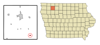
Maynard is a city in Fayette County, Iowa, United States. The population was 476 at the time of the 2020 census.

<span class="mw-page-title-main">Lakeshire, Missouri</span> City in Missouri, United States

Lakeshire is a city in St. Louis County, Missouri, United States. The population was 1,432 at the 2010 census.

<span class="mw-page-title-main">Bloomfield, Nebraska</span> City in Nebraska, United States

Bloomfield is a city in Knox County, Nebraska, United States. The population was 1,028 at the 2010 census.

<span class="mw-page-title-main">Seama, New Mexico</span> Census-designated place in New Mexico, United States

Seama is a census-designated place (CDP) in Cibola County, New Mexico, United States. The population was 465 at the 2010 census.

<span class="mw-page-title-main">Sylvan Beach, New York</span> Village in New York, United States

Sylvan Beach is a village in Oneida County, New York, United States; in the southeastern end of the Town of Vienna. It is twenty-two miles west of Rome. At the 2010 census, the population of Sylvan Beach was 897.

Pulteney is a town in Steuben County, New York, United States. The population was 1,260 at the 2020 census. The name is derived from the name of the original pioneer tract of land.

<span class="mw-page-title-main">Jud, North Dakota</span> City in North Dakota, United States

Jud is a rural city in LaMoure County, North Dakota, United States. The population was 65 at the 2020 census. Jud was founded in 1904 and named for county settler Judson LaMoure. It is located along unpaved 61st Street SE, 9 miles (14 km) west of U.S. Route 281 and 25 miles (40 km) south of Interstate 94 in the midst of settled farmland and open plains.

<span class="mw-page-title-main">Logan Township, Blair County, Pennsylvania</span> Township in Pennsylvania, United States

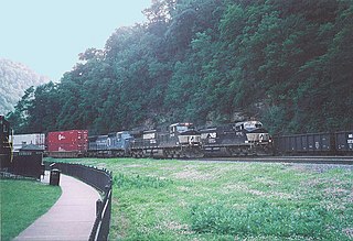
Logan Township is a township in Blair County, Pennsylvania, United States. It is part of the Altoona, PA Metropolitan Statistical Area. It is the most populous township in Blair County, with a population of 12,413 at the 2020 census. Logan Township is home to Horseshoe Curve, a National Historic Landmark.

<span class="mw-page-title-main">Washington Township, Schuylkill County, Pennsylvania</span> Township in Pennsylvania, United States

Washington Township is a township that is located in Schuylkill County, Pennsylvania, United States. The population was 3,134 at the time of the 2020 census.

<span class="mw-page-title-main">Colley Township, Sullivan County, Pennsylvania</span> Township in Pennsylvania, United States

Colley Township is a township in Sullivan County, Pennsylvania, United States. The population was 626 at the 2020 census. The village of Lopez is located in the township.

<span class="mw-page-title-main">Hunker, Pennsylvania</span> Borough in Pennsylvania, United States

Hunker is a borough which is located in Westmoreland County, Pennsylvania, United States. It has been part of the Pittsburgh metropolitan area since 1950.

Stateburg is a census-designated place (CDP) in the High Hills of Santee in Sumter County, South Carolina, United States. The population was 1,380 at the 2010 census. It is included in the Sumter, South Carolina Metropolitan Statistical Area. Stateburg is located within the larger Stateburg Historic District.

<span class="mw-page-title-main">Central City, South Dakota</span> City in South Dakota, United States

Central City is a city in Lawrence County, South Dakota, United States. The population was 93 at the 2020 census.

<span class="mw-page-title-main">Millersburg, Indiana</span> Town in Indiana, United States

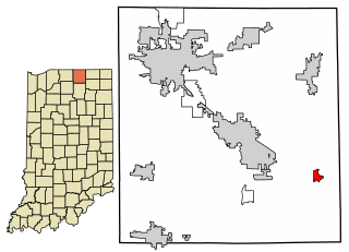
Millersburg is a town in Clinton and Benton townships, Elkhart County, Indiana, United States. The population was 903 at the 2010 census.

References

  1. "2020 U.S. Gazetteer Files". United States Census Bureau. Retrieved March 16, 2022.
  2. 1 2 "2020 Census State Redistricting Data". census.gov. United states Census Bureau. Retrieved August 12, 2021.
  3. The History of Linn County, Iowa: Containing a History of the County, Its Cities, Towns, &c. Western Historical Company. 1878. p. 592.
  4. "National Register Information System". National Register of Historic Places . National Park Service. July 9, 2010.
  5. "US Gazetteer files: 2010, 2000, and 1990". United States Census Bureau. February 12, 2011. Retrieved April 23, 2011.
  6. "US Gazetteer files 2010". United States Census Bureau. Archived from the original on January 25, 2012. Retrieved May 11, 2012.
  7. "Census of Population and Housing". Census.gov. Retrieved June 4, 2015.
  8. "U.S. Census website". United States Census Bureau . Retrieved May 11, 2012.
  9. "U.S. Census website". United States Census Bureau . Retrieved January 31, 2008.
  10. "CENTRAL CITY" (PDF). Iowa Department of Education . Retrieved August 23, 2020.