Whittier, Iowa

Last updated

Whittier, Iowa
USA Iowa location map.svg
Red pog.svg
Whittier
Location in Iowa
Usa edcp location map.svg
Red pog.svg
Whittier
Location in the United States
Coordinates: 42°05′41″N91°27′46″W / 42.09472°N 91.46278°W / 42.09472; -91.46278
Country United States
State Iowa
County Linn
Township Brown
Elevation
915 ft (279 m)
Time zone UTC-6 (Central (CST))
  Summer (DST) UTC-5 (CDT)
Area code 319
GNIS feature ID463015

Whittier is an unincorporated community in Linn County, Iowa, United States.

Contents

Geography

Whittier is located at the intersections of County Roads X20 and E34 south of Waubeek and west of Viola, at 42.092976N, -91.462973W. [1]

History

Whittier was founded as a Quaker community. Originally known as Quaker Corners, the community was founded in Brown Township. [2]

The original meetinghouse in Whittier was constructed in 1864, and this building also served as a schoolhouse until 1878. The replacement building, the Whittier Friends Meeting House, was built directly in front of the original building, and was constructed in 1893. [2] It is listed on the National Register of Historic Places. [3]

A schoolhouse was built in 1878. In 1893, a general store was opened by the Hall family, who also operated the post office. The village was renamed to Whittier in honor of the Quaker poet and abolitionist John Greenleaf Whittier. [2]

Whittier's population was 28 in 1902, [4] In 1918, a community hall was built in Whittier. [2]

The population was 100 in 1940. [5] The Quaker school and the post office and the post office closed in the 1950s. [2]

In 2008, the Linn County Planning and Development Commission announced a planning document to guide the development of Whittier; this plan included limited growth, including acknowledgement and reflection of the community's Quaker heritage. [2]

See also

Related Research Articles

<span class="mw-page-title-main">Linn County, Iowa</span> County in Iowa, United States

Linn County is a county located in the U.S. state of Iowa. As of the 2020 census, the population was 230,299, making it the second-most populous county in Iowa. The county seat is Cedar Rapids. Linn County is named in honor of Senator Lewis F. Linn of Missouri. Linn County is included in the Cedar Rapids, IA Metropolitan Statistical Area.

<span class="mw-page-title-main">Monti, Iowa</span> Unincorporated community in Iowa, United States

Monti is an unincorporated community located in the southeast corner of Buchanan County, Iowa, in the United States. Founded in the 1880s and platted in 1905, the community lies on the west bank of Buffalo Creek, 6 miles (10 km) east of Quasqueton and 8 miles (13 km) west of Ryan.

<span class="mw-page-title-main">Newton Township, Buchanan County, Iowa</span> Township in Iowa, United States

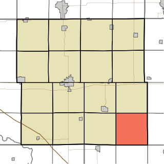
Newton Township is one of sixteen townships in Buchanan County, Iowa, USA. As of the 2000 census, its population was 423.

Troy Mills is an unincorporated community in northern Linn County, Iowa, United States. It lies along local roads north of the city of Cedar Rapids, the county seat of Linn County. Its elevation is 869 feet (265 m). Although Troy Mills is unincorporated, it has a post office, with the ZIP code of 52344, which opened on 10 June 1867, and a full volunteer fire department.

<span class="mw-page-title-main">Unique, Iowa</span> Ghost town in Iowa, United States

Unique was a hamlet in Weaver Township, Humboldt County, Iowa, United States.

Arbon is an unincorporated community in Power County, Idaho, United States.

Waubeek is an unincorporated community in Linn County, Iowa, United States.

Arbor Hill is an unincorporated community or ghost town in Adair County, Iowa, United States.

Avon is an unincorporated community in Polk County, Iowa, United States.

Berea was an unincorporated community in Eureka Township, Adair County, Iowa, United States.

Poplar is a rural unincorporated community in Audubon County, Iowa, in the United States. It is part of the Poplar Rural District which is recognized as a rural historic district and was the largest rural settlement of Danish immigrants in the United States.

Fern is an unincorporated community located in the thirty-second section of Beaver Township, Grundy County, Iowa. As of February 2022 it has 14 inhabited houses.

Vandalia is an unincorporated community in Jasper County, in the U.S. state of Iowa.

Macy is a former unincorporated community in northern Hardin County, in the U.S. state of Iowa.

Utica is an unincorporated community in Van Buren County, in the U.S. state of Iowa.

Galesburg is an unincorporated community in Jasper County, in the U.S. state of Iowa.

Alice is an unincorporated community in Linn County, in the U.S. state of Iowa.

Astor was an unincorporated community in Crawford County, in the U.S. state of Iowa.

Beckwith is an unincorporated community in Jefferson County, in the U.S. state of Iowa.

Lafayette or La Fayette is an unincorporated community in Linn County, in the U.S. state of Iowa.

References

  1. "US Gazetteer files: 2010, 2000, and 1990". United States Census Bureau. February 12, 2011. Archived from the original on July 20, 2006. Retrieved April 23, 2011.
  2. 1 2 3 4 5 6 "Whittier Village Plan". LinnCountyIowa.gov. 2008. Archived from the original on March 27, 2023. Retrieved January 17, 2024.
  3. National Register of Historic Places, 1966-1994: Cumulative List Through January 1, 1994. National Park Service. 1994. p. 229. ISBN   978-0-89133-254-1. Archived from the original on January 17, 2024. Retrieved January 17, 2024.
  4. Cram's Modern Atlas: The New Unrivaled New Census Edition. J. R. Gray & Company. 1902. pp. 203–207. Archived from the original on December 29, 2023. Retrieved June 17, 2021.
  5. The Attorneys List. United States Fidelity and Guaranty Company, Attorney List Department. 1940. p. 315. Archived from the original on November 3, 2022. Retrieved November 8, 2022.