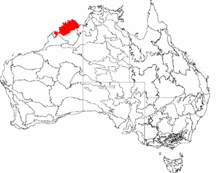
The Northern Kimberley, an interim Australian bioregion, is located in the northern Kimberley region of Western Australia, comprising 8,420,100 hectares.

The Victoria Bonaparte, an interim Australian bioregion, is located in the Northern Territory and Western Australia, comprising 7,301,242 hectares.

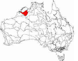
Dampierland is an interim Australian bioregion in Western Australia. The region is also a distinct physiographic section of the larger Nullagine Platform province, which in turn is part of the larger West Australian Shield division.

Central Ranges is an Australian bioregion, with an area of 101,640.44 square kilometres spreading across two states and one territory: South Australia, Western Australia, and the Northern Territory. It forms a large part of the World Wide Fund for Nature Central Ranges xeric scrub ecoregion.

New South Wales North Coast or NSW North Coast, an interim Australian bioregion, is located in New South Wales, comprising 3,996,591 hectares.
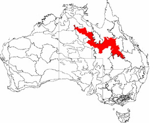
The Mitchell Grass Downs (MGD) is an IBRA biogeographic region, located in the Northern Territory and Queensland, which comprises an area of 33,468,761 hectares with eight subregions.

The Tasmanian Central Highlands is an interim Australian bioregion located in central highlands region of Tasmania, comprising 767,849 hectares.

Tasmanian West is an interim Australian bioregion located in the western region of Tasmania, comprising 1,565,077 hectares.

The Pine Creek biogeographic region, an interim Australian bioregion, is located in the Northern Territory, and comprises 2,851,777 hectares.

The Gulf Coastal, an interim Australian bioregion, is located in the Northern Territory, comprising 2,711,718 hectares.

The Gulf Fall and Uplands, an interim Australian bioregion, is located in the Northern Territory and Queensland, comprising 11,847,909 hectares.

Burt Plain, an interim Australian bioregion, is located in the Northern Territory, and comprises 7,379,719 hectares.

The Simpson Strzelecki Dunefields, an interim Australian bioregion, comprises 27,984,283 hectares, and is part of four state/territories of Australia: the Northern Territory, South Australia, New South Wales and Queensland

Mount Isa Inlier, an interim Australian bioregion, is located in the Queensland, and comprises 6,778,263 hectares.
The Pacific Subtropical Islands is an interim Australian bioregion which includes Norfolk Island and Lord Howe Island. Its IBRA code is PSI.

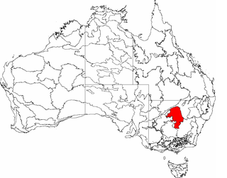
Central Mackay Coast, an interim Australian bioregion, is located in Queensland, and comprises 1,464,208 hectares.
Cobar Peneplain, an interim Australian bioregion, is located in New South Wales, and comprises 7,385,346 hectares.

Finke, an interim Australian bioregion, comprises 7,267,416 hectares, and is part of two state/territories of Australia: the Northern Territory and South Australia. It is part of the Central Ranges xeric scrub ecoregion.

Stony Plains, an interim Australian bioregion, comprises 13,166,372 hectares, and is part of two state/territories of Australia: the Northern Territory and South Australia.

Tanami is an interim Australian bioregion, comprising 25,997,277 hectares in the Northern Territory and Western Australia. It is part of the Great Sandy-Tanami desert ecoregion.