Hampton bioregion

Last updated

Hampton
Western Australia
Euclasanddune.JPG
Sand dunes and dune scrub near Eucla
IBRA 6.1 Hampton.png
The interim Australian bioregions,
with Hampton in red
Area10,881.98 km2 (4,201.6 sq mi)
Localities around Hampton:
Nullarbor Nullarbor Nullarbor
Coolgardie Hampton Great Australian Bight
Mallee Great Australian Bight Great Australian Bight

Hampton is an interim Australian bioregion located in southeastern coastal Western Australia, with a small portion (4%) extending into adjacent South Australia. [1] [2] It has an area of 1,088,198 hectares (2,689,000 acres). [3] The Hampton bioregion is part of the Coolgardie woodlands ecoregion.

Contents

Geography

The bioregion includes a coastal plain, known as the Roe Plains, covered by extensive marine dunes, with a limestone escarpment, known as the Hampton Tableland or Hampton Range, emerging to the north of the dune fields. The bioregion is bounded on the north by the Nullarbor Plain, and on the south by the Great Australian Bight. [4]

The escarpment is an outcrop of the Eucla Basin, a sedimentary geologic basin that extends under the entire region as well as the Nullarbor Plain to the north and under the sea to the south. Erosion of the Eucla Basin's limestone by rainwater and groundwater has created a karst landscape, with extensive underground sinkholes and caverns. [4]

The region has a semi-arid Mediterranean climate, with mild to hot summers and cool to mild winters. The bioregion receives about 250mm of rainfall annually, mostly during the winter months. [2]

Flora and fauna

The plant communities of the bioregion include mallee woodlands and shrublands on scree slopes, limestone pavements, and dunes. They are characterised by mallee, shrubs or trees, generally eucalypts, with multiple stems rising from an underground woody base called a lignotuber. An endemic subspecies of coastal white mallee, Eucalyptus diversifolia hesperia, is a common mallee species. [2] Mallee with patches of acacia scrub, featuring ridge-fruited mallee ( Eucalyptus angulosa ), coastal wattle ( Acacia cyclops ), Calothamnus quadrifidus , and granite bottlebrush ( Melaleuca elliptica ), is found on coastal dunes. Yorrell ( Eucalyptus gracilis ) is found on limestone and lime sands. [5]

There are eucalypt woodlands, and open low woodlands of western myall ( Acacia papyrocarpa ) over bluebush ( Maireana sp.), on the alluvial and calcareous plains below the escarpment. [4] [5] The hemiparasitic desert quandong or native peach (Santalum acuminatum) is found in the woodlands. [2] Low dune vegetation, including Scaevola crassifolia and Atriplex cinerea , are found on more recent dune deposits. [4]

Native birds include the malleefowl (Leipoa ocellata) and western subspecies of grey currawong (Strepera versicolor plumbei) and slender-billed thornbill (Acanthiza iredalei iredalei). The dunes are home to three endemic species of reptiles, Pseudemoia baudini, Lerista arenicola , and Lerista baynesi , along with one endemic sub-species ( Ctenotus brooksi euclae ). [4]

Several species of cave fauna are endemic to the cave systems of the bioregion, which extend under the adjacent Nullarbor Plain. These include the spiders Tartarus mullamullangensis and Tartarus nurinensis . [4]

Threats

Threats to the bioregion include overgrazing by sheep, invasive animals like foxes, wild dogs, feral cats, starlings, camels, horses and rabbits, and invasive plants like Ward's weed ( Carrichtera annua ) and sea spurge ( Euphorbia paralias ). [4] [2]

Protected areas

Protected areas include Nuytsland Nature Reserve and Eucla National Park in Western Australia, and Nullarbor National Park which protects the entire South Australian section. [2]

The Eyre Bird Observatory is located in coastal mallee woodland in Nuytsland Nature Reserve. It was established in 1977, and includes a natural history library and a small museum. [6]

Related Research Articles

Carnarvon xeric shrublands Terrestrial ecoregion in Western Australia

The Carnarvon xeric shrublands is a deserts and xeric shrublands ecoregion of Western Australia. The ecoregion is coterminous with the Carnarvon Interim Biogeographic Regionalisation for Australia (IBRA) bioregion.

Southwest Australia Biogeographic region of Western Australia

Southwest Australia is a biogeographic region in Western Australia. It includes the Mediterranean-climate area of southwestern Australia, which is home to a diverse and distinctive flora and fauna.

Swan Coastal Plain IBRA biogeographic region, region in Western Australia

The Swan Coastal Plain in Western Australia is the geographic feature which contains the Swan River as it travels west to the Indian Ocean. The coastal plain continues well beyond the boundaries of the Swan River and its tributaries, as a geological and biological zone, one of Western Australia's Interim Biogeographic Regionalisation for Australia (IBRA) regions. It is also one of the distinct physiographic provinces of the larger West Australian Shield division.

Esperance Plains Bioregion in Western Australia

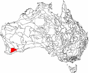
Esperance Plains, also known as Eyre Botanical District, is a biogeographic region in southern Western Australia on the south coast between the Avon Wheatbelt and Hampton bioregions, and bordered to the north by the Mallee region. It is a plain punctuated by granite and quartz outcrops and ranges, with a semi-arid Mediterranean climate and vegetation consisting mostly of mallee-heath and proteaceous scrub. About half of the region has been cleared for intensive agriculture. Recognised as a bioregion under the Interim Biogeographic Regionalisation for Australia (IBRA), it was first defined by John Stanley Beard in 1980.

Mallee bioregion Biogeographic region in southern Western Australia

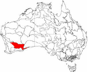
Mallee, also known as Roe Botanical District, is a biogeographic region in southern Western Australia. Located between the Esperance Plains, Avon Wheatbelt and Coolgardie bioregions, it has a low, gently undulating topography, a semi-arid mediterranean climate, and extensive Eucalyptus mallee vegetation. It has an area of 73,975.59 square kilometres (28,562.13 sq mi). About half of the region has been cleared for intensive agriculture. Recognised as a region under the Interim Biogeographic Regionalisation for Australia (IBRA), it was first defined by John Stanley Beard in 1980.

Esperance mallee

Esperance mallee is an ecoregion on the south coast of Western Australia, a coastal strip where the predominant vegetation consists of short eucalyptus trees and shrubs.

Western Mallee

Western Mallee is an Interim Biogeographic Regionalisation for Australia (IBRA) subregion in southern Western Australia. It is a sparsely populated subregion with an area of about 47,000 square kilometres, roughly centred on the town of Newdegate. Largely cleared for intensive agriculture, it still retains patches of native vegetation, but these are under environmental stress from threats such as rising salinity, and are poorly managed.

Eastern Mallee Biogeographic region in Western Australia

Eastern Mallee is an Interim Biogeographic Regionalisation for Australia (IBRA) subregion in southern Western Australia.

Avon Wheatbelt Bioregion in Western Australia

The Avon Wheatbelt is a bioregion in Western Australia. It has an area of 9,517,104 hectares. It is considered part of the larger Southwest Australia savanna ecoregion.

Coolgardie bioregion Bioregion in Western Australia

Coolgardie is an Australian bioregion consisting of an area of low hills and plains of infertile sandy soil in Western Australia. It has an area of 129,122.09 square kilometres (49,854.32 sq mi). It includes much of the Great Western Woodlands.

Ord Victoria Plain Bioregion in Australia

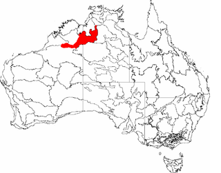
The Ord Victoria Plain, an interim Australian bioregion, is located in the Northern Territory and Western Australia, comprising 12,540,703 hectares.

Yalgoo bioregion Bioregion in Western Australia

Yalgoo is an interim Australia bioregion located in Western Australia. It has an area of 5,087,577 hectares. The bioregion, together with the Avon Wheatbelt and Geraldton Sandplains bioregions, is part of the larger Southwest Australia savanna ecoregion as classified by the World Wildlife Fund.

Geography of Western Australia

Western Australia occupies nearly one third of the Australian continent. Due to the size and the isolation of the state, considerable emphasis has been made of these features; it is the second largest administrative territory in the world, after Yakutia in Russia, despite the fact that Australia is only the sixth largest country in the world by area, and no other regional administrative jurisdiction in the world occupies such a high percentage of a continental land mass. It is also the only first level administrative subdivision to occupy the entire continental coastline in one cardinal direction.

Brigalow Belt

The Brigalow Belt is a wide band of acacia-wooded grassland that runs between tropical rainforest of the coast and the semi-arid interior of Queensland, Australia. The Interim Biogeographic Regionalisation for Australia (IBRA) divides the Brigalow Belt into two IBRA regions, or bioregions, Brigalow Belt North (BBN) and Brigalow Belt South (BBS). The North and South Brigalow Belt are two of the 85 bioregions across Australia and the 15 bioregions in Queensland. Together they form most of the Brigalow tropical savanna ecoregion.

Coolgardie woodlands Terrestrial ecoregion in Western Australia

The Coolgardie woodlands is an ecoregion in southern Western Australia. The predominant vegetation is woodlands and mallee scrub. The ecoregion is a transitional zone between the Mediterranean-climate forests, woodlands, and shrublands of Southwest Australia and the deserts and dry scrublands of the Australian interior.

Eyre Yorke Block

The Eyre Yorke Block, also known as the Eyre and Yorke mallee, is an interim Australian (IBRA) bioregion and a World Wildlife Fund ecoregion covering part of the Eyre Peninsula and all of Yorke Peninsula as well as land to its immediate east in South Australia.

Roe Plains Plain in the southeast of Western Australia

The Roe Plains is a coastal plain in the southeastern corner of Western Australia.

Pilbara shrublands Terrestrial ecoregion in Western Australia

The Pilbara shrublands is a deserts and xeric shrublands ecoregion in Western Australia. It is coterminous with the Pilbara IBRA region. For other definitions and uses of "Pilbara region" see Pilbara.

Gawler bioregion Region in South Australia

Gawler is an interim Australian bioregion located in South Australia. It has an area of 12,002,883 hectares. Gawler bioregion is part of the Tirari–Sturt stony desert ecoregion.

References

  1. Environment Australia. "Revision of the Interim Biogeographic Regionalisation for Australia (IBRA) and Development of Version 5.1 – Summary Report" (PDF). Department of the Environment and Water Resources, Australian Government . Retrieved 7 May 2022.{{cite journal}}: Cite journal requires |journal= (help)
  2. 1 2 3 4 5 6 "Hampton". Natural Resources, Adelaide and Mt Lofty Ranges, Government of South Australia. Accessed 7 May 2022.
  3. "Interim Biogeographic Regionalisation for Australia (IBRA7) regions and codes". Department of Sustainability, Environment, Water, Population and Communities. Commonwealth of Australia. 2012. Retrieved 7 May 2022.
  4. 1 2 3 4 5 6 7 Sandra Gilfillan, Malcolm Grant, Sarah Comer, Sarah Barrett, Klaus Tiedemann and Lawrie Anderson (2001). "Hampton (HAM)", in A Biodiversity Audit of Western Australia’s 53 Biogeographical Subregions in 2002. Department of Conservation and Land Management. Accessed 7 May 2022.
  5. 1 2 Beard, J. S.; Beeston, G. R.; Harvey, J. M.; Hopkins, A. J. M.; and Shepherd, D. P. (2013) "The vegetation of Western Australia at the 1:3,000,000 scale. Explanatory memoir. Second edition." Conservation Science Western Australia; October 2013, Vol. 9 Issue 1, p1-152, 153p.
  6. "Eyre Bird Observatory". Parks and Wildlife Service, Government of Western Australia. Accessed 8 May 2022.

Further reading