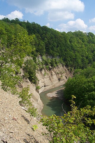
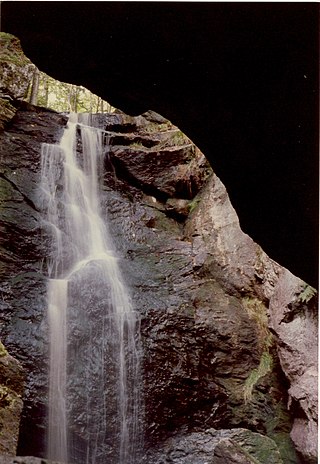
Chesterfield Gorge was initially carved from the metamorphic bedrock by torrents of glacial meltwater. Today, the gorge continues to be shaped by the East Branch of the Westfield River. The walls of the gorge are quite steep, more than 30 feet (9.1m) in some places. During periods of low water, it is possible to get down to the floor of the gorge, but it is not recommended, and no trails exist from the cliff edge to the bottom. Rock climbing is prohibited. The surrounding forest features oak, pine, and hemlock, and is home to bears, bobcats, and turkeys, among many others. A half-mile trail along the cliff top offers views of the gorge, the river, and the forest. A railing runs along the length of the cliff for safety. Along the cliff ledge are fields of boulders, some of which are quite massive.
Stone abutments of a bridge that once spanned the river are all that remain of the old post road between Boston, Massachusetts and Albany, New York. A toll gate was established at its eastern end, but no trace of it exists today. During the American Revolution, British redcoats marched over this bridge to Boston following General Burgoyne's defeat at Saratoga, New York. In 1835, floodwaters swept away the bridge along with some nearby grist and sawmills. A short trail leads along the river upstream from the gorge to the remains of the old bridge. A more extensive trail network extends southward down the river, through the Hiram H. Fox Wildlife Management Area and towards Knightville Dam.
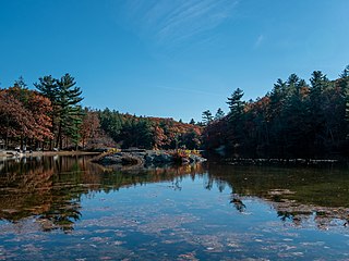
Chesterfield Gorge is the entrance to an extensive natural area along the Westfield River, and is designated a National Wild and Scenic River. Fly fishing for trout is a popular pastime. Atlantic salmon are stocked here, and must not be confused with the local trout, as it is illegal to keep them if caught.
Chesterfield is a rural hill town in Hampshire County, Massachusetts, United States, 26 miles (42 km) east of Pittsfield and 90 miles (140 km) west of Boston. The population was 1,186 at the 2020 census. It is part of the Springfield, Massachusetts Metropolitan Statistical Area.
The Berkshires are a highland geologic region located in the western parts of Massachusetts and northwestern Connecticut. The term "Berkshires" is normally used by locals in reference to the portion of the Vermont-based Green Mountains that extend south into western Massachusetts; the portion extending further south into northwestern Connecticut is grouped with the Connecticut portion of the Taconic Mountains and referred to as either the Northwest Hills or Litchfield Hills.
The Trustees of Reservations is a non-profit land conservation and historic preservation organization dedicated to preserving natural and historical places in the Commonwealth of Massachusetts. It is the oldest land conservation nonprofit organization of its kind in the world and has 140,000 dues-paying members as of 2018. In addition to land stewardship, the organization is also active in conservation partnerships, community supported agriculture (CSA), environmental and conservation education, community preservation and development, and green building. The Trustees of Reservations own title to 120 properties on 27,000 acres (11,000 ha) in Massachusetts, all of which are open to the public; it maintains conservation restrictions on over 200 additional properties. Properties include historic mansions, estates, and gardens; woodland preserves; waterfalls; mountain peaks; wetlands and riverways; coastal bluffs, beaches, and barrier islands; farmland and CSA projects; and archaeological sites.
The William Cullen Bryant Homestead is the boyhood home and later summer residence of William Cullen Bryant (1794–1878), one of America's foremost poets and newspaper editors. The 155-acre (63 ha) estate is located at 205 Bryant Road in Cummington, Massachusetts, overlooks the Westfield River Valley and is currently operated by the non-profit Trustees of Reservations. It is open to the public on weekends in summer and early fall for tours with an admission fee.
Breakheart Reservation is a public recreation area covering 652 acres (264 ha) in the towns of Saugus and Wakefield, Massachusetts. The reservation features a hardwood forest, two freshwater lakes, a winding stretch of the Saugus River, and scenic views of Boston and rural New England from rocky hilltops. The park is managed by the Massachusetts Department of Conservation and Recreation.
The Metacomet-Monadnock Trail is a 114-mile-long (183 km) hiking trail that traverses the Metacomet Ridge of the Pioneer Valley region of Massachusetts and the central uplands of Massachusetts and southern New Hampshire. Although less than 70 miles (110 km) from Boston and other large population centers, the trail is considered remarkably rural and scenic and includes many areas of unique ecologic, historic, and geologic interest. Notable features include waterfalls, dramatic cliff faces, exposed mountain summits, woodlands, swamps, lakes, river floodplain, farmland, significant historic sites, and the summits of Mount Monadnock, Mount Tom and Mount Holyoke. The Metacomet-Monadnock Trail is maintained largely through the efforts of the Berkshire Chapter of the Appalachian Mountain Club (AMC). Much of the trail is a portion of the New England National Scenic Trail.
Bartholomew's Cobble is a 329-acre (1.33 km2) National Natural Landmark, open space preserve, agricultural preserve, and bio-reserve located in southwest Massachusetts in the village of Ashley Falls abutting Canaan, Connecticut. The preserve contains more than 800 plant species, including North America's greatest diversity of ferns and the greatest overall biodiversity in Berkshire County, Massachusetts; it also contains Massachusetts' highest populations of ground nesting bobolinks. It was declared a National Natural Landmark in October 1971.
Mashpee River Reservation is a park in Mashpee, Massachusetts on the Mashpee River. The Trustees of Reservations owns and maintains the park.
Kankakee River State Park is an Illinois state park on 4,000 acres (1,619 ha) primarily in Kankakee and Will Counties, Illinois, United States. Originally, 35 acres (14 ha) of land was donated by Ethel Sturges Dummer for the creation of the state park in 1938. Another 1,715 acres (694 ha) was donated by Commonwealth Edison in 1956, which again donated more land in 1989. The islands of Smith, Hoffman, Langham, and Willow are all located inside the park on the Kankakee River.
Chapel Brook of Franklin County, Massachusetts is a tributary of the South River and the name of a 173-acre (70 ha) open space preserve located along the brook. The brook, est. 3.79 mi (6.10 km) long, is located in southeast Ashfield and southwest Conway. It drains into Poland Brook, thence into the South River, the Deerfield River, the Connecticut River, and Long Island Sound. The Chapel Brook reservation, managed by the non-profit conservation organization The Trustees of Reservations, is located in Ashfield and contains Chapel Falls, a series of three waterfalls on Chapel Brook, measuring 10 feet (3.0 m), 15 feet (4.6 m) and 20 feet (6.1 m) high; and Pony Mountain est. 1,400 feet (430 m), a 100-foot (30 m) open granite cliff face and popular recreational rock climbing site.
Peaked Mountain is a nature reserve located in Monson, Massachusetts. The property is approximately 2,000 acres (8.1 km2) and is owned by The Trustees of Reservations, a non-profit conservation organization. The principal landowners of its western slope, Leonard and Roslyn Harrington and Richard Elliott, have long permitted the public to hike through their properties to the summit. Concerned about the mountain's future, they sought the assistance of The Trustees of Reservations in developing a long-term strategy for protecting the mountain and securing public access after their lifetimes.
Zoar Valley is an area of deep gorges along the Main and South branches of Cattaraugus Creek in western New York, United States. The valley is located along the border of Erie County and Cattaraugus County, roughly between the villages of Gowanda to the west and Springville to the east.
The Mount Tom Range is a traprock mountain range located in the Connecticut River Valley of Massachusetts. It is part of the Metacomet Ridge that extends from Long Island Sound near New Haven, Connecticut, north through the Connecticut River Valley of Massachusetts to nearly the Vermont border. A popular outdoor recreation resource, the range is known for its continuous west facing cliffs and its rugged, scenic character. It is also notable for its unique microclimate ecosystems and rare plant communities, as well as significant historic sites, such as the ruins of the 18th century Eyrie House located on Mount Nonotuck.
The Metacomet Ridge, Metacomet Ridge Mountains, or Metacomet Range of southern New England is a narrow and steep fault-block mountain ridge known for its extensive cliff faces, scenic vistas, microclimate ecosystems, and rare or endangered plants. The ridge is an important recreation resource located within 10 miles (16 km) of more than 1.5 million people, offering four long-distance hiking trails and over a dozen parks and recreation areas, including several historic sites. It has been the focus of ongoing conservation efforts because of its natural, historic, and recreational value, involving municipal, state, and national agencies and nearly two dozen non-profit organizations.
Royalston Falls is a 50 foot (15 m) waterfall and granite gorge located in Royalston, Massachusetts along Falls Brook, a tributary of the Tully River which in turn is a tributary of the Millers River. The falls are part of a 217-acre (88 ha) open space preserve acquired in 1951 by the land conservation non-profit organization The Trustees of Reservations. The 22-mile (35 km) Tully Trail and the 110-mile (180 km) Metacomet-Monadnock Trail, a National Recreation Trail, pass through the property.
Tekoa Mountain, 1,121 feet (342 m), is a dramatic, rocky high point overlooking the Westfield River Gorge at the eastern edge of the Berkshire plateau in the towns of Montgomery and Russell, Massachusetts, USA. Tekoa Mountain, very prominent from the "Jacob's Ladder" section of U.S. Route 20 in the town of Russell, is not a true mountain but a cleaver jutting from a dissected plateau; it was produced by glacial action and through continuous erosion by the Westfield River and Moose Meadow Brook before and after the last ice age.
Bear's Den is a 6-acre (24,000 m2) nature reserve in New Salem, Massachusetts. The reservation is close to the Quabbin Reservoir and is owned by the Trustees of Reservations.
Petticoat Hill is the name of a 1,180 foot hill and a 60-acre (24 ha) open space reservation located in Williamsburg, Massachusetts in the eastern Berkshire Mountains. The reservation, occupying the east side of the hill, is managed by The Trustees of Reservations (TTOR), a non-profit conservation organization. The hill and reservation are characterized by steep slopes largely wooded with northern hardwood forest species, particularly eastern hemlock.
Quinebaug Woods is a 36-acre (15 ha) open space preserve located in Holland, Massachusetts. The property, acquired in 2001 by the land conservation non-profit organization The Trustees of Reservations, is named for the Quinebaug River, which runs through the reservation.
Noon Hill and Shattuck Reservation are adjacent open space preserves located in Medfield, Massachusetts. They are managed by the land conservation non-profit organization The Trustees of Reservations. The 200-mile (320 km) Bay Circuit Trail passes through both properties. The Town of Medfield owns conservation land adjacent to the properties.
This page is based on this Wikipedia article Text is available under the CC BY-SA 4.0 license; additional terms may apply. Images, videos and audio are available under their respective licenses.