Chester is a city and is also the county town of Cheshire, United Kingdom.
Morrow County is a county located in the U.S. state of Ohio. As of the 2010 census, the population was 34,827. Its county seat is Mount Gilead. The county was organized in 1848 from parts of four neighboring counties and named for Jeremiah Morrow, Governor of Ohio from 1822 to 1826. Shawnee people used the area for hunting purposes before white settlers arrived in the early 19th century.

North Dundas is a township in Eastern Ontario, Canada, in the United Counties of Stormont, Dundas and Glengarry.
Chesterville may refer to:

Chester Township is one of the sixteen townships of Morrow County, Ohio, United States. The 2010 census found 1,872 people in the township, 228 of whom lived in the village of Chesterville.

Maryland Route 291 (MD 291) is a state highway in the U.S. state of Maryland. The highway runs 18.34 miles (29.52 km) from MD 20 in Chestertown east to the Delaware state line east of Millington, where the highway continues east as Delaware Route 6 (DE 6). MD 291 parallels the Chester River along the southern edge of Kent County and connects Chestertown with U.S. Route 301 (US 301). The highway follows much of what was originally MD 447, which was constructed between US 213 in Chestertown and MD 290 at Chesterville around 1930. MD 291 itself was built east of Millington around 1930. The highway was extended west toward Chesterville in the early 1930s, but it was not complete to MD 290 until the late 1940s. MD 291 was extended west to US 213 along a partially new alignment in the early 1960s, superseding MD 447. MD 291 was reconstructed along its entire length between the mid-1960s and mid-1970s, and it reached its present western terminus at MD 20 in 1969.
Samuel Plummer Morrill was a nineteenth-century politician and minister from Maine.
Orren D. Casselman was an Ontario merchant and political figure. He represented Dundas in the House of Commons of Canada from 1917 to 1921 as a Unionist member.

Chesterville is an unincorporated community in Sparta Township, Dearborn County, Indiana.

Chesterville is an unincorporated community in Kent County, Maryland, United States. It is located at the intersection of Maryland Route 290 and Maryland Route 447.
This is a list of the National Register of Historic Places listings in Hampton, Virginia.
Jarvis House may refer to:
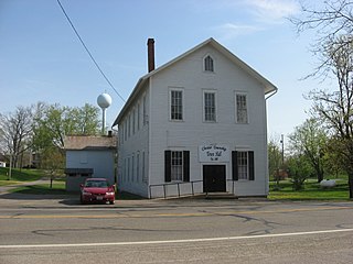
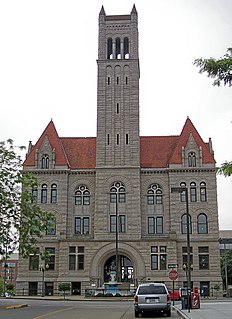
The Chester Town Hall is a historic governmental building and community meeting place in the village of Chesterville, Ohio, United States. Built in the 1860s by the village and a fraternal society, it has served as home for both entities throughout its history, as well as providing space for Chester Township officials and community gatherings. Along with numerous other buildings in the village, it has been named a historic site.

Chesterville is an unincorporated community in Douglas County, Illinois, United States. Chesterville is located on Illinois Route 133, 4 miles (6.4 km) east of Arthur.

Chesterville is a town in eThekwini in the KwaZulu-Natal province of South Africa.
Union School or Old Union School or variations may refer to:

Chesterville is an unincorporated community in eastern Colorado County, in the U.S. state of Texas. It is located in a farming region northeast of Eagle Lake at the junction of Farm to Market Road 1093 (FM 1093) and Farm to Market Road 2764 (FM 2764). A large grain storage facility is a significant landmark in the area.

Chesterville Plantation Site is a historic archaeological site located near NASA Langley Research Center, Hampton, Virginia. The main house was built about 1771, and was a two-story brick house set on a high basement, with a three-bay gable end front, and stuccoed brick walls. The site includes the remains of the house, the ruins of a building with a ballast stone foundation, the foundation of a brick kiln, a cemetery, and scattered evidence of 17th century occupation. In 1755 George Wythe (1726-1806) inherited the property believed to have been his birthplace, and built the Chesterville Plantation house about 1771. It was his primary place of residence until 1775 and he continued to operate a plantation there until 1792. The mansion was destroyed by fire in 1911.

Chesterville is an unincorporated community in Franklin Township in Chester County, Pennsylvania, United States. Chesterville is located at the intersection of Pennsylvania Route 841, Chesterville Road, and North Creek Road.
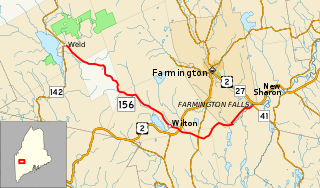
State Route 156 (SR 156) is a 23-mile-long (37 km) state highway in the U.S. state of Maine. It is located entirely in Franklin County and runs between Weld and the Chesterville village of Farmington Falls.