Blennerhassett, West Virginia

Last updated
Blennerhassett, West Virginia
CDP
WVMap-doton-Blennerhassett.PNG
Location of Blennerhassett, West Virginia
Coordinates: 39°15′15″N81°37′25″W / 39.25417°N 81.62361°W / 39.25417; -81.62361
Country United States
State West Virginia
County Wood
Area
  Total5.0 sq mi (13.0 km2)
  Land5.0 sq mi (13.0 km2)
  Water0.0 sq mi (0.0 km2)
Elevation
[1]
686 ft (209 m)
Population
 (2010)
  Total3,089
  Density620/sq mi (240/km2)
Time zone UTC-5 (Eastern (EST))
  Summer (DST) UTC-4 (EDT)
Area code 304
FIPS code 54-08308 [2]
GNIS feature ID2389216 [1]

Blennerhassett is a census-designated place (CDP) in Wood County, West Virginia, United States. It is part of the Parkersburg-Marietta-Vienna, WV-OH Metropolitan Statistical Area. The population was 3,089 at the 2010 census. [3]

Contents

Blennerhassett, WV. Blennerhassett, WV.JPG
Blennerhassett, WV.

History

This community is named after Blennerhassett Island, an island in the Ohio River near the area. The island's name originated from the owner of the island in the 19th century: Harman Blennerhassett, an Anglo-Irish immigrant to the United States.[ citation needed ]

Geography

According to the United States Census Bureau, the CDP has a total area of 5.0 square miles (13.0 km2), all land.

Demographics

At the 2000 census, [2] there were 3,225 people, 1,227 households and 996 families living in the CDP. The population density was 643.8 per square mile (248.5/km2). There were 1,271 housing units at an average density of 253.7/sq mi (98.0/km2). The racial makeup of the CDP was 98.45% White, 0.56% African American, 0.03% Native American, 0.50% Asian, and 0.47% from two or more races. Hispanic or Latino of any race were 0.37% of the population.

There were 1,227 households, of which 32.8% had children under the age of 18 living with them, 72.2% were married couples living together, 5.9% had a female householder with no husband present, and 18.8% were non-families. 16.9% of all households were made up of individuals, and 5.8% had someone living alone who was 65 years of age or older. The average household size was 2.61 and the average family size was 2.91.

Age distribution was 24.1% under the age of 18, 5.9% from 18 to 24, 27.2% from 25 to 44, 29.8% from 45 to 64, and 13.0% who were 65 years of age or older. The median age was 41 years. For every 100 females there were 99.8 males. For every 100 females age 18 and over, there were 98.9 males.

The median household income was $51,250, and the median family income was $56,513. Males had a median income of $45,478 versus $25,156 for females. The per capita income for the CDP was $22,485. About 1.8% of families and 2.2% of the population were below the poverty line, including 2.1% of those under age 18 and 1.2% of those age 65 or over.

Related Research Articles

Selmont-West Selmont is a census-designated place (CDP) in Dallas County, Alabama, United States. At the 2020 census, the population was 2,158.

<span class="mw-page-title-main">Tara Hills, California</span> Census-designated place in California, United States

Tara Hills is a census-designated place (CDP) in Contra Costa County, California, United States. The population was 5,126 at the 2010 census.

<span class="mw-page-title-main">St. James City, Florida</span> Census-designated place in Florida, United States

St. James City is an unincorporated community and census-designated place (CDP) on Pine Island in Lee County, Florida, United States. The population was 3,876 at the 2020 census, up from 3,784 at the 2010 census. It is part of the Cape Coral-Fort Myers, Florida Metropolitan Statistical Area.

<span class="mw-page-title-main">Wainaku, Hawaii</span> Census-designated place in Hawaii, U.S.

Wainaku is a census-designated place (CDP) in Hawaiʻi County, Hawaiʻi, United States. The population was 1,147 at the 2020 census.

Coyne Center is a census-designated place (CDP) in Rock Island County, Illinois, United States. The population was 827 at the 2010 census.

<span class="mw-page-title-main">Forest Oaks, North Carolina</span> Census-designated place in North Carolina, United States

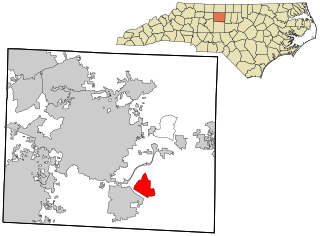
Forest Oaks is a census-designated place (CDP) in Guilford County, North Carolina, United States. The population was 3,890 as of the 2010 census, up from 3,241 in 2000.

<span class="mw-page-title-main">Northgate, Ohio</span> Census-designated place in Ohio, United States

Northgate is a census-designated place (CDP) in Colerain Township, Hamilton County, Ohio, United States. The population was 7,277 at the 2020 census.

<span class="mw-page-title-main">Leisuretowne, New Jersey</span> Populated place in Burlington County, New Jersey, US

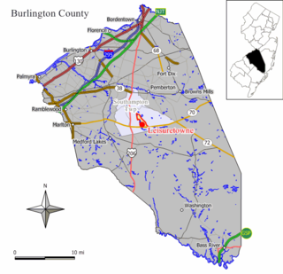
Leisuretowne is an unincorporated community and census-designated place (CDP) located within Southampton Township, in Burlington County, in the U.S. state of New Jersey. As of the 2010 United States Census, the CDP's population was 3,582.

<span class="mw-page-title-main">Bellwood, Virginia</span> CDP in Virginia, United States

Bellwood is a census-designated place (CDP) in Chesterfield County, Virginia, United States. The population was 6,352 at the 2010 census. The community takes its name from Bellwood, one of the James River Plantations.

<span class="mw-page-title-main">Switzer, West Virginia</span> Census-designated place in West Virginia, United States

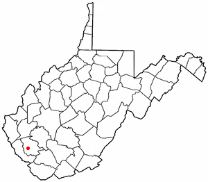
Switzer is an unincorporated community and census-designated place (CDP) in Logan County, West Virginia, United States. The CDP includes the neighboring unincorporated community of Micco. The total CDP population was 595 at the 2010 census.

<span class="mw-page-title-main">Gilbert Creek, West Virginia</span> CDP in West Virginia, United States

Gilbert Creek is a census-designated place (CDP) in Mingo County, West Virginia, United States. The population was 1,090 at the 2010 census. The community takes its name from nearby Gilbert Creek.

<span class="mw-page-title-main">Beaver, West Virginia</span> Census-designated place in West Virginia, United States

Beaver is a census-designated place (C.D.P.) in Raleigh County, West Virginia, United States. The population was 1,308 at the 2010 census.

<span class="mw-page-title-main">Coal City, West Virginia</span> Census-designated place in West Virginia, United States

Coal City is a census-designated place (CDP) in Raleigh County, West Virginia, United States. The population was 1,815 at the 2010 census. Coal City's population is composed of other surrounding unincorporated communities.

<span class="mw-page-title-main">MacArthur, West Virginia</span> Census-designated place in West Virginia, United States

MacArthur is a census-designated place (CDP) in Raleigh County, West Virginia, United States. Originally, it was named Hollywood and renamed MacArthur after General of the Army Douglas MacArthur in 1942. The population was 1,500 at the 2010 census.

<span class="mw-page-title-main">Piney View, West Virginia</span> Census-designated place in West Virginia, United States

Piney View is a census-designated place (CDP) in Raleigh County, West Virginia, United States. The population was 989 at the 2010 census.

<span class="mw-page-title-main">Prosperity, West Virginia</span> Census-designated place in West Virginia, United States

Prosperity is a census-designated place (CDP) in Raleigh County, West Virginia, United States. The population was 1,498 at the 2010 census.

<span class="mw-page-title-main">Boaz, West Virginia</span> CDP in West Virginia, United States

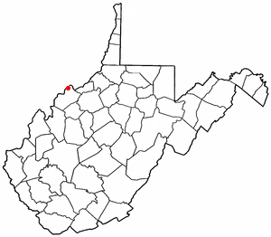
Boaz is a census-designated place (CDP) in Wood County, West Virginia, United States. It is part of the Parkersburg-Marietta-Vienna, WV-OH Metropolitan Statistical Area. As of the 2020 census, the CDP population was 1,321.

<span class="mw-page-title-main">Lubeck, West Virginia</span> CDP in West Virginia, United States

Lubeck is a census-designated place (CDP) in Wood County, West Virginia, United States. It is part of the Parkersburg-Marietta-Vienna, WV-OH Metropolitan Statistical Area. The population was 1,311 at the 2010 census. Though first named Watertown, postmaster Theodore Frederick Henry Slevogt in 1856 changed the name to Lubeck after his hometown in Germany.

Lake Luzerne-Hadley was a census-designated place (CDP) in Saratoga and Warren counties in the U.S. state of New York. The portion in Warren County is part of the Glens Falls Metropolitan Statistical Area. The CDP consisted of the centers of population in the towns of Hadley and Lake Luzerne.

Hollins is a census-designated place (CDP) in Botetourt and Roanoke County, Virginia, United States. Hollins covers much of the area known locally as "North County". The population was 15,574 at the 2020 census. It is part of the Roanoke Metropolitan Statistical Area. The area is also the home of Hollins University in addition to four properties listed on the National Register of Historic Places: the Black Horse Tavern-Bellvue Hotel and Office, Harshbarger House, the Hollins College Quadrangle, and Old Tombstone.

References

  1. 1 2 U.S. Geological Survey Geographic Names Information System: Blennerhassett, West Virginia
  2. 1 2 "U.S. Census website". United States Census Bureau . Retrieved 2008-01-31.
  3. "U.S. Census website". United States Census Bureau . Retrieved 2011-05-14.