
The Appalachian Mountains, often called the Appalachians, are a system of mountains in eastern to northeastern North America. The Appalachians first formed roughly 480 million years ago during the Ordovician Period. They once reached elevations similar to those of the Alps and the Rocky Mountains before experiencing natural erosion. The Appalachian chain is a barrier to east–west travel, as it forms a series of alternating ridgelines and valleys oriented in opposition to most highways and railroads running east–west.
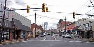
Oak Hill is a city in Fayette County, West Virginia, United States. The population was 8,179 at the 2020 census. It is part of the Beckley metropolitan area.

The Blue Ridge Mountains are a physiographic province of the larger Appalachian Mountains range. The mountain range is located in the Eastern United States, and extends 550 miles southwest from southern Pennsylvania through Maryland, West Virginia, Virginia, North Carolina, South Carolina, Tennessee, and Georgia. This province consists of northern and southern physiographic regions, which divide near the Roanoke River gap. To the west of the Blue Ridge, between it and the bulk of the Appalachians, lies the Great Appalachian Valley, bordered on the west by the Ridge and Valley province of the Appalachian range.

Pin Oak is an unincorporated community in Hampshire County in the U.S. state of West Virginia. Pin Oak is located along West Virginia Route 29 between Paw Paw and Forks of Cacapon. Pin Oak is roughly centered at the intersection of Pin Oak Road and Cabin Run Road with West Virginia Route 29. The old Pinoak School lies north of this intersection.
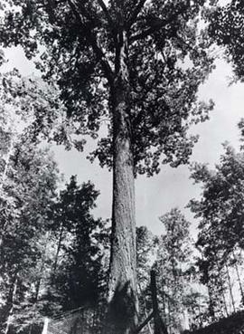
The Mingo Oak was a white oak in the U.S. state of West Virginia. First recognized for its age and size in 1931, the Mingo Oak was the oldest and largest living white oak tree in the world until its death in 1938.

Southern West Virginia is a culturally and geographically distinct region in the U.S. state of West Virginia. Southern West Virginia is known for its coal mining heritage and Southern affinity. The region is also closely identified with Southwestern Virginia and Southeastern Kentucky, with close proximity to Western North Carolina and East Tennessee. Today, Southern West Virginia continues to grapple with poverty and declining population. The region is located in West Virginia's 1st congressional district, which is represented by Carol Miller.
Oak Flat is an unincorporated community on the South Fork South Branch Potomac River located in Pendleton County, West Virginia, United States. Oak Flat lies along U.S. Highway 33.
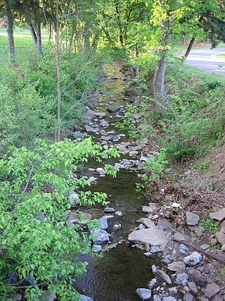
Big Run is a 4.4-mile-long (7.1 km) tributary stream of the South Branch Potomac River, belonging to the Potomac River and Chesapeake Bay watersheds. Big Run flows through the city of Romney and the campus of the West Virginia Schools for the Deaf and Blind in Hampshire County, West Virginia. The stream is known by local residents as Town Run and Town Creek.

Peters Mountain is a 52-mile (84 km) mountain in the U.S. states of Virginia and West Virginia. It is located on the border between Alleghany County, VA, Monroe County, WV, Giles Co.,VA, and Craig Co.,VA. Its elevation ranges from 4,073 feet (1,241 m) on the mountaintop to a low of 2,300 feet (700 m). It produces some of the water supply for Monroe County.
Mossy is an unincorporated community in Fayette County, West Virginia, United States. Mossy is located off exit 60 on the West Virginia Turnpike and is west of Oak Hill. As of 1993, the community had an Exxon gas station, and motel, all owned by Teddy Gray.
White Oak is an unincorporated community in Raleigh County, West Virginia, United States. White Oak is located on West Virginia Route 3, 1.5 miles (2.4 km) southeast of Shady Spring. White Oak has a post office with ZIP code 25989.
Carlisle is an unincorporated community in Fayette County, West Virginia, United States. Carlisle is located on West Virginia Route 612, 2 miles (3.2 km) southwest of Oak Hill.

The natural environment of Virginia encompasses the physical geography and biology of the U.S. state of Virginia. Virginia has a total area of 42,774.2 square miles (110,784.67 km2), including 3,180.13 square miles (8,236.5 km2) of water, making it the 35th-largest state by area. Forests cover 65% of the state, wetlands and water cover 6% of the land in the state, while 5% of the state is a mixture of commercial, residential, and transitional.

Burke Centre is a planned residential community located west of Burke in Fairfax County, Virginia, United States. Burke Centre is a planned community managed by the Burke Centre Conservancy homeowners' association (HOA).

Fair Oaks is a census-designated place in Fairfax County, Virginia, United States. The population as of the 2010 census was 30,223. It encompasses a large area west of the city of Fairfax, centered on Fair Oaks Mall. Suburban neighborhoods and office parks occupy most of Fair Oaks, largely developed since the 1980s.
Midway is an unincorporated community in Fayette County, West Virginia, United States. Midway is located near the northern border of Oak Hill.
Oak Hill is an unincorporated community in Jackson County, West Virginia, United States.
Oak Ridge is an unincorporated community in Fayette County, West Virginia, United States.


