Chilhowee, Missouri

Last updated

Chilhowee, Missouri
Chilhowee Water Towers.jpg
Johnson County Missouri Incorporated and Unincorporated areas Chilhowee Highlighted.svg
Location of Chilhowee, Missouri
Coordinates: 38°35′20″N93°51′16″W / 38.58889°N 93.85444°W / 38.58889; -93.85444 [1]
Country United States
State Missouri
County Johnson
Area
[2]
  Total0.36 sq mi (0.93 km2)
  Land0.36 sq mi (0.93 km2)
  Water0.00 sq mi (0.00 km2)
Elevation
[1]
922 ft (281 m)
Population
 (2020)
  Total291
  Density806.09/sq mi (311.64/km2)
Time zone UTC-6 (Central (CST))
  Summer (DST) UTC-5 (CDT)
ZIP code
64733
Area code 660
FIPS code 29-13654 [3]
GNIS feature ID0729719 [1]

Chilhowee is a village in south central Johnson County, Missouri, United States. It is situated along Missouri Route 2. The population was 325 at the 2010 census.

Contents

History

Chilhowee was originally called Simpson's Store, and under the latter name was founded in the mid-1850s, and named after James Simpson, a local merchant. [4] A post office called Chilhowee has been in operation since 1859. [5] The present name is of Native American origin. [6]

The Chilhowee Historic District was listed on the National Register of Historic Places in 1988. [7]

Geography

Chilhowee is located on Missouri Route 2 approximately two miles west of Post Oak and Missouri Route 13. Old Chilhowee is one mile north on Missouri Route F and Denton is four miles to the northwest on Route 2. The location is on the broad drainage divide between Post Oak Creek to the north and Big Creek tributaries to the south. [8]

According to the United States Census Bureau, the village has a total area of 0.38 square miles (0.98 km2), all land. [9]

Demographics

Historical population
CensusPop.Note
1870 185
1880 86−53.5%
1910 425
1920 46910.4%
1930 414−11.7%
1940 4150.2%
1950 335−19.3%
1960 3391.2%
1970 297−12.4%
1980 34917.5%
1990 335−4.0%
2000 329−1.8%
2010 325−1.2%
2020 291−10.5%
U.S. Decennial Census [10]

2010 census

As of the census [11] of 2010, there were 325 people, 129 households, and 85 families living in the village. The population density was 855.3 inhabitants per square mile (330.2/km2). There were 163 housing units at an average density of 428.9 per square mile (165.6/km2). The racial makeup of the village was 95.4% White, 0.9% Native American, and 3.7% from two or more races. Hispanic or Latino of any race were 1.2% of the population.

There were 129 households, of which 36.4% had children under the age of 18 living with them, 42.6% were married couples living together, 14.0% had a female householder with no husband present, 9.3% had a male householder with no wife present, and 34.1% were non-families. 28.7% of all households were made up of individuals, and 15.5% had someone living alone who was 65 years of age or older. The average household size was 2.52 and the average family size was 3.02.

The median age in the village was 35.1 years. 29.8% of residents were under the age of 18; 7.8% were between the ages of 18 and 24; 25.6% were from 25 to 44; 21.5% were from 45 to 64; and 15.4% were 65 years of age or older. The gender makeup of the village was 50.5% male and 49.5% female.

2000 census

As of the census [3] of 2000, there were 329 people, 142 households, and 78 families living in the village. The population density was 858.6 inhabitants per square mile (331.5/km2). There were 165 housing units at an average density of 430.6 per square mile (166.3/km2). The racial makeup of the village was 95.74% White, 0.61% African American, 0.30% Native American, and 3.34% from two or more races.

There were 142 households, out of which 28.9% had children under the age of 18 living with them, 46.5% were married couples living together, 7.0% had a female householder with no husband present, and 44.4% were non-families. 39.4% of all households were made up of individuals, and 23.2% had someone living alone who was 65 years of age or older. The average household size was 2.32 and the average family size was 3.20.

In the village the population was spread out, with 26.1% under the age of 18, 9.7% from 18 to 24, 29.2% from 25 to 44, 18.2% from 45 to 64, and 16.7% who were 65 years of age or older. The median age was 37 years. For every 100 females there were 98.2 males. For every 100 females age 18 and over, there were 99.2 males.

The median income for a household in the village was $29,688, and the median income for a family was $45,938. Males had a median income of $27,500 versus $20,625 for females. The per capita income for the village was $14,850. About 4.1% of families and 9.3% of the population were below the poverty line, including 11.7% of those under age 18 and 19.2% of those age 65 or over.

Points of interest

Related Research Articles

<span class="mw-page-title-main">Butterfield, Missouri</span> City in Missouri, United States

Butterfield is a city in Butterfield Township, Barry County, Missouri, United States. The population was 378 at the 2020 census.

<span class="mw-page-title-main">Jerico Springs, Missouri</span> Village in Missouri, United States

Jerico Springs is a village in Cedar County, Missouri, United States. The population was 160 at the 2020 census.

<span class="mw-page-title-main">Big Lake, Missouri</span> Village in Missouri, United States

Big Lake is a village in Holt County, Missouri, United States. The population was 65 at the 2020 census.

<span class="mw-page-title-main">Airport Drive, Missouri</span> Village in Missouri, United States

Airport Drive is a village in Jasper County, Missouri, United States. The population was 766 at the 2020 census. It is part of the Joplin, Missouri Metropolitan Statistical Area. The community is still commonly referred to as "Stone's Corner," as the intersection of Route 43 and Route 171 is known.

<span class="mw-page-title-main">Wentworth, Missouri</span> Village in Missouri, United States

Wentworth is a village in northeastern Newton County, Missouri, United States. The population was 151 at the 2010 census. It is part of the Joplin, Missouri Metropolitan Statistical Area.

<span class="mw-page-title-main">Clyde, Missouri</span> Village in Missouri, United States

Clyde is a village in eastern Nodaway County, Missouri, United States. The population was 82 at the 2010 census.

<span class="mw-page-title-main">Bakersfield, Missouri</span> Village in Missouri, United States

Bakersfield is a village in southeastern Ozark County in the Ozarks of southern Missouri, United States. The population was 186 at the 2020 census.

<span class="mw-page-title-main">Pascola, Missouri</span> Village in Missouri, United States

Pascola is a village in Pemiscot County, Missouri, United States. The population was 108 at the 2010 census.

<span class="mw-page-title-main">Tarrants, Missouri</span> Village in Missouri, United States

Tarrants is a village in central Pike County, Missouri, United States. The population was 22 at the 2010 census.

<span class="mw-page-title-main">Powersville, Missouri</span> Village in Missouri, United States

Powersville is a village in northwest Putnam County, Missouri, United States. The population was 42 at the 2020 census.

<span class="mw-page-title-main">Roscoe, Missouri</span> Village in Missouri, United States

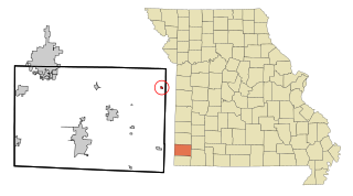
Roscoe is a village in St. Clair County, Missouri, United States. The population was 89 at the 2020 census.

<span class="mw-page-title-main">Bull Creek, Missouri</span> Village in Missouri, United States

Bull Creek is a village in northwest Taney County, Missouri, United States. The population was 426 at the 2020 census. It is part of the Branson, Missouri Micropolitan Statistical Area.

<span class="mw-page-title-main">Merriam Woods, Missouri</span> City in Missouri, United States

Merriam Woods is a city in Taney County, Missouri, United States. The population was 2,006 at the 2020 census. It is part of the Branson, Missouri Micropolitan Statistical Area.

<span class="mw-page-title-main">Deerfield, Missouri</span> Village in Missouri, United States

Deerfield is a village in Vernon County, Missouri, United States. The population was 40 at the 2020 census.

<span class="mw-page-title-main">Richards, Missouri</span> Village in Missouri, United States

Richards is a village in northwest Vernon County, Missouri, United States. The population was 96 at the 2010 census.

<span class="mw-page-title-main">Lock Springs, Missouri</span> Village in Missouri, United States

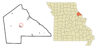
Lock Springs is a village in southeast Daviess County, Missouri, United States. The population was 40 at the 2020 census.

<span class="mw-page-title-main">Mount Moriah, Missouri</span> Village in Missouri, United States

Mount Moriah is a village in eastern Harrison County, Missouri, United States. The population at the 2020 census was 75.

<span class="mw-page-title-main">Raymondville, Missouri</span> Town in Missouri, United States

Raymondville is a town in Texas County, Missouri, United States. The population was 345 at the 2020 census.

<span class="mw-page-title-main">Ionia, Missouri</span> Village in Missouri, United States

Ionia is a village in northern Benton and southern Pettis counties in the U.S. state of Missouri. The population was 88 at the 2010 census.

<span class="mw-page-title-main">Argyle, Missouri</span> Town in Missouri, United States

Argyle is a town in Maries and Osage counties in the U.S. state of Missouri. The population was 144 at the 2020 census.

References

  1. 1 2 3 U.S. Geological Survey Geographic Names Information System: Chilhowee, Missouri
  2. "ArcGIS REST Services Directory". United States Census Bureau. Retrieved August 28, 2022.
  3. 1 2 "U.S. Census website". United States Census Bureau . Retrieved January 31, 2008.
  4. "Johnson County Place Names, 1928–1945 (archived)". The State Historical Society of Missouri. Archived from the original on June 24, 2016. Retrieved October 20, 2016.{{cite web}}: CS1 maint: bot: original URL status unknown (link)
  5. "Post Offices". Jim Forte Postal History. Archived from the original on May 25, 2015. Retrieved October 19, 2016.
  6. Bright, William (2004). Native American Placenames of the United States. University of Oklahoma Press. p. 100. ISBN   978-0-8061-3598-4.
  7. "National Register Information System". National Register of Historic Places . National Park Service. July 9, 2010.
  8. Missouri Atlas & Gazetteer, DeLorme, First Edition 1998, p.35, ISBN   0899332242
  9. "US Gazetteer files 2010". United States Census Bureau. Archived from the original on January 25, 2012. Retrieved July 8, 2012.
  10. "Census of Population and Housing". Census.gov. Retrieved June 4, 2015.
  11. "U.S. Census website". United States Census Bureau . Retrieved July 8, 2012.