Clarendon Parish, New Brunswick

Last updated

Clarendon Parish
Paroisse de Clarendon
Charlotte County NB - Clarendon Parish.png
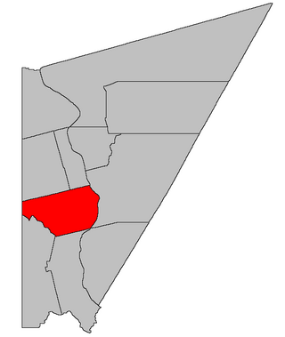
Location within Charlotte County.
Country Flag of Canada (Pantone).svg  Canada
Province Flag of New Brunswick.svg  New Brunswick
County Charlotte County
Erected1869
Named for George Villiers, 4th Earl of Clarendon
Area
[1]
  Land492.11 km2 (190.00 sq mi)
Population
 (2021) [1]
  Total66
  Density0.1/km2 (0.3/sq mi)
  Change 2016-2021
Increase2.svg 4.8%
  Dwellings
64
Time zone UTC-4 (AST)
  Summer (DST) UTC-3 (ADT)

Clarendon is a geographic parish in Charlotte County, New Brunswick, Canada, [4] located in the interior to the north of Point Lepreau and southwest of CFB Gagetown.

Contents

For governance purposes, Clarendon is part of the Capital Region rural district, [5] which is a member of the Capital Region Regional Service Commission. [6]

Prior to the 2023 governance reform, the parish comprised a single local service district (LSD), which was a member of Capital Region Service Commission (RSC11). [7]

The Census subdivision of the same name shares the parish's boundaries. [1]

Origin of name

The parish was named for Clarendon Settlement, which in turn was named in honour of the Earl of Clarendon, British Secretary of State for Foreign Affairs at the time of it being laid out. [8]

History

Clarendon was erected in 1869 from Lepreau and Pennfield Parishes. [9]

The area was first laid out for settlement in 1856, [10] with the Clarendon Settlement being largest. Much of the parish was never surveyed for settlement, most of the surveyed lots were never granted, and many granted lots were later reconveyed to the Crown. [11]

In 1868 the Clarendon District was created as a polling district taking in the northern part of Lepreau and Pennfield Parishes. [12]

Boundaries

Clarendon Parish is bounded: [2] [13] [14]

Local service district

The local service district of the parish of Clarendon comprised the entire parish. [15]

The LSD was established in 1975 to assess for fire protection; [16] recreational and sport facilities was added in 2008. [17]

In 2021, the LSD assessed for community & recreation services in addition to the basic LSD services of fire protection, police services, land use planning, emergency measures, and dog control. [18] The taxing authority is 507.00 Clarendon.

Communities

Communities at least partly within the parish. [13] [14] [19] italics indicate a name no longer in official use

Bodies of water

Bodies of water [lower-alpha 1] at least partly within the parish. [13] [14] [19]

Islands

Islands at least partly within the parish. [13] [14] [19]

Other notable places

Parks, historic sites, and other noteworthy places at least partly within the parish. [13] [14] [19]

Demographics

Revised census figures based on the 2023 local governance reforms have not been released.

Population

Canada census – Clarendon community profile
2021 2016 2011
Population66 (+4.8% from 2016)63 (+21.2% from 2011)52 (-26.8% from 2006)
Land area492.11 km2 (190.00 sq mi)492.19 km2 (190.04 sq mi)492.91 km2 (190.31 sq mi)
Population density0.1/km2 (0.26/sq mi)0.1/km2 (0.26/sq mi)0.1/km2 (0.26/sq mi)
Median age58.8 (M: 58.4, F: 61.2)59.2 (M: 59.8, F: 57.7)58.0 (M: 59.5, F: 56.5)
Private dwellings64 (total)  40 (occupied)90 (total) 76 (total) 
Median household income$44,928$.N/A
Notes: Income data for this area has been suppressed for data quality or confidentiality reasons.
References: 2021 [22] 2016 [23] 2011 [24] earlier [25] [26]
Historical Census Data - Clarendon Parish, New Brunswick
YearPop.±%
1991 53    
1996 51−3.8%
YearPop.±%
2001 41−19.6%
2006 71+73.2%
YearPop.±%
2011 52−26.8%
2016 63+21.2%
[27] [28]

Language

Canada Census Mother Tongue - Clarendon Parish, New Brunswick [27]
2001 & 2006 language data for this area has been suppressed for data quality or confidentiality reasons.
CensusTotal
French
English
French & English
Other
YearResponsesCountTrendPop %CountTrendPop %CountTrendPop %CountTrendPop %
2011
50
50Steady2.svg 0.0%100.00%0Steady2.svg 0.0%0.00%0Steady2.svg 0.0%0.00%0Steady2.svg 0.0%0.00%
1996
50
50n/a100.00%0n/a0.00%0n/a0.00%0n/a0.00%

Access Routes

Highways and numbered routes that run through the parish, including external routes that start or finish at the parish limits: [29]

Notes

  1. Not including brooks, ponds or coves.

Related Research Articles

<span class="mw-page-title-main">Addington Parish, New Brunswick</span> Parish in New Brunswick, Canada

Addington is a geographic parish in Restigouche County, New Brunswick, Canada.

<span class="mw-page-title-main">Wicklow Parish, New Brunswick</span> Parish in New Brunswick, Canada

Wicklow is a geographic parish in Carleton County, New Brunswick, Canada, forming the northwestern corner of Carleton County.

<span class="mw-page-title-main">Balmoral Parish, New Brunswick</span> Parish in New Brunswick, Canada

Balmoral is a geographic parish in Restigouche County, New Brunswick, Canada.

<span class="mw-page-title-main">Huskisson Parish, New Brunswick</span> Parish in New Brunswick, Canada

Huskisson is a geographic parish in Kent County, New Brunswick, Canada.

<span class="mw-page-title-main">Wakefield Parish, New Brunswick</span> Parish in New Brunswick, Canada

Wakefield is a geographic parish in Carleton County, New Brunswick, Canada, located north on the west bank of the Saint John River north of Woodstock.

<span class="mw-page-title-main">Richmond Parish, New Brunswick</span> Parish in New Brunswick, Canada

Richmond is a geographic parish in Carleton County, New Brunswick, Canada, located west of Woodstock.

<span class="mw-page-title-main">New Maryland Parish, New Brunswick</span> Parish in New Brunswick, Canada

New Maryland is a geographic parish in York County, New Brunswick, Canada.

<span class="mw-page-title-main">Saint Andrews Parish, New Brunswick</span> Parish in Canada

Saint Andrews Parish is a geographic parish in Charlotte County, New Brunswick, Canada, located east of St. Stephen.

<span class="mw-page-title-main">Hillsborough Parish, New Brunswick</span> Parish in New Brunswick, Canada

Hillsborough is a geographic parish in eastern Albert County, New Brunswick, Canada.

<span class="mw-page-title-main">Alma Parish, New Brunswick</span> Parish in New Brunswick, Canada

Alma is a geographic parish on the Bay of Fundy in the southwestern corner of Albert County, New Brunswick, Canada.

<span class="mw-page-title-main">Musquash Parish, New Brunswick</span> Parish in New Brunswick, Canada

Musquash is a geographic parish in Saint John County, New Brunswick, Canada.

<span class="mw-page-title-main">Petersville Parish, New Brunswick</span> Parish in New Brunswick, Canada

Petersville is a geographic parish in Queens County, New Brunswick, Canada.

<span class="mw-page-title-main">Lepreau Parish, New Brunswick</span> Parish in Canada

Lepreau is a geographic parish in Charlotte County, New Brunswick, Canada, west of Saint John.

<span class="mw-page-title-main">Pennfield Parish, New Brunswick</span> Parish in Canada

Pennfield is a geographic parish in Charlotte County, New Brunswick, Canada, located west of Saint John located east of St. George and west of Saint John.

<span class="mw-page-title-main">West Isles Parish, New Brunswick</span> Parish in Canada

West Isles is a geographic parish in Charlotte County, New Brunswick, Canada.

<span class="mw-page-title-main">Saint George Parish, New Brunswick</span> Parish in Canada

Saint George is a geographic parish in Charlotte County, New Brunswick, Canada, located between St. Stephen and Saint John.

<span class="mw-page-title-main">Dumbarton Parish, New Brunswick</span> Parish in Canada

Dumbarton is a geographic parish in Charlotte County, New Brunswick, Canada, located inland north of St. George and south of Harvey.

<span class="mw-page-title-main">Dufferin Parish, New Brunswick</span> Parish in Canada

Dufferin is a geographic parish in Charlotte County, New Brunswick, Canada, located east of St. Stephen.

<span class="mw-page-title-main">Saint Stephen Parish, New Brunswick</span> Parish in Canada

Saint Stephen is a geographic parish in Charlotte County, New Brunswick, Canada, located in the southwestern corner of the province.

<span class="mw-page-title-main">Saint David Parish, New Brunswick</span> Parish in Canada

Saint David is a geographic parish in Charlotte County, New Brunswick, Canada, located northeast of St. Stephen and northwest of Saint Andrews.

References

  1. 1 2 3 "Census Profile". Statistics Canada. 26 October 2022. Retrieved 29 October 2022.
  2. 1 2 "Chapter T-3 Territorial Division Act". Government of New Brunswick. Retrieved 5 June 2023.
  3. "Chapter I-13 Interpretation Act". Government of New Brunswick. Retrieved 5 June 2023.
  4. The Territorial Division Act [2] divides the province into 152 parishes, the cities of Saint John and Fredericton, and one town of Grand Falls. The Interpretation Act [3] clarifies that parishes include any local government within their borders.
  5. "Regional Service Commission 11: RD 11". Government of New Brunswick. Retrieved 5 June 2023.
  6. "Regions Regulation – Regional Service Delivery Act". Government of New Brunswick. 21 July 2022. Retrieved 5 June 2023.
  7. "Communities in each of the 12 Regional Service Commissions (RSC) / Les communautés dans chacune des 12 Commissions de services régionaux (CSR)" (PDF), Government of New Brunswick, July 2017, retrieved 2 February 2021
  8. Ganong, William F. (1896). A Monograph of the Place-Nomenclature of the Province of New Brunswick. Royal Society of Canada. p. 227. Retrieved 17 March 2021.
  9. "32 Vic. c. 51 An Act to erect part of the Parishes of Lepreaux and Pennfield, in the County of Charlotte, into a separate Town or Parish.". Acts of the General Assembly of Her Majesty's Province of New Brunswick. Passed in the Month of April 1869. Fredericton: Government of New Brunswick. 1869. pp. 96–97. Available as a free ebook from Google Books.
  10. Ganong, p. 208
  11. "No. 155". Provincial Archives of New Brunswick. Department of Natural Resources and Energy Development. Retrieved 13 November 2020.
  12. "31 Vic. c. 51 An Act to establish an additional Polling place in the County of Charlotte.". Acts of the General Assembly of Her Majesty's Province of New Brunswick. Passed in the Month of March 1868. Fredericton: Government of New Brunswick. 1868. p. 84. Available as a free ebook from Google Books.
  13. 1 2 3 4 5 "No. 147". Provincial Archives of New Brunswick. Department of Natural Resources and Energy Development. Retrieved 3 July 2021. Remainder of parish on maps 155, 156, 162, and 163 at same site.
  14. 1 2 3 4 5 "442" (PDF). Transportation and Infrastructure. Government of New Brunswick. Retrieved 3 July 2021. Remainder of parish on mapbooks 457, 458, 470, and 471 at same site.
  15. "New Brunswick Regulation 84-168 under the Municipalities Act (O.C. 84-582)". Government of New Brunswick. Retrieved 6 February 2021.
  16. "Regulation 75–4 under the Municipalities Act (O. C. 75–33)". The Royal Gazette. 133. Fredericton: 80. 29 January 1975.
  17. "Regulation 2008-157 under the Municipalities Act (O. C. 2008-553)" (PDF). The Royal Gazette. 167. Fredericton: 96–97. 14 January 2009. ISSN   1714-9428.
  18. "2020 Local Government Statistics for New Brunswick" (PDF). Department of Environment and Local Government. p. 55. Retrieved 6 February 2021.
  19. 1 2 3 4 "Search the Canadian Geographical Names Database (CGNDB)". Government of Canada. Retrieved 4 July 2021.
  20. "New Brunswick Regulation 94-43 under the Fish and Wildlife Act (O.C. 94-231)". Government of New Brunswick. 5 June 2006. Retrieved 8 July 2021.
  21. "Explore New Brunswick's Protected Natural Areas". GeoNB. Retrieved 4 July 2021.
  22. "2021 Community Profiles". 2021 Canadian Census . Statistics Canada. 4 February 2022. Retrieved 19 October 2023.
  23. "2016 Community Profiles". 2016 Canadian Census . Statistics Canada. 12 August 2021. Retrieved 8 September 2019.
  24. "2011 Community Profiles". 2011 Canadian Census . Statistics Canada. 21 March 2019. Retrieved 15 March 2014.
  25. "2006 Community Profiles". 2006 Canadian Census . Statistics Canada. 20 August 2019.
  26. "2001 Community Profiles". 2001 Canadian Census . Statistics Canada. 18 July 2021.
  27. 1 2 Statistics Canada: 1996, 2001, 2006, 2011 census
  28. "Census Profile, 2016 Census: Clarendon, Parish [Census subdivision], New Brunswick". Statistics Canada. Retrieved 8 September 2019.
  29. Atlantic Canada Back Road Atlas ISBN   978-1-55368-618-7 Pages 4, 12


45°25′16″N66°37′32″W / 45.421076°N 66.625471°W / 45.421076; -66.625471 (Clarendon Parish, New Brunswick)