Claysburg, Pennsylvania

Last updated
Claysburg, Pennsylvania
Map of Claysburg, Blair County, Pennsylvania Highlighted.png
Claysburg (depicted in red) in Blair County
Coordinates: 40°17′35″N78°27′7″W / 40.29306°N 78.45194°W / 40.29306; -78.45194 Coordinates: 40°17′35″N78°27′7″W / 40.29306°N 78.45194°W / 40.29306; -78.45194
Country United States
State Pennsylvania
County Blair
Township Greenfield
Area
[1]
  Total1.34 sq mi (3.46 km2)
  Land1.34 sq mi (3.46 km2)
  Water0.00 sq mi (0.00 km2)
Population
 (2020) [2]
  Total1,291
  Density965.59/sq mi (372.86/km2)
Time zone UTC-5 (Eastern (EST))
  Summer (DST) UTC-4 (EDT)
ZIP code
16625
Area code 814
Local phone exchange239
Website www.claysburgpa.com

Claysburg is a census-designated place (CDP) along Interstate 99 and the Allegheny Front in Blair County, Pennsylvania, United States, situated near the base of Blue Knob. As of the 2020 census, it had a population of 1,291.

Contents

Demographics

Historical population
CensusPop.
2020 1,291
U.S. Decennial Census [3] [2]

As of the census [4] of 2000, there were 1,503 people, 616 households, and 442 families residing in the CDP. There were 653 housing units at an average density of 254.9/sq mi (98.5/km2). The racial makeup of the CDP was 98.54% White, 0.13% African American, 0.33% from other races, and 1.00% from two or more races. Hispanic or Latino of any race were 0.73% of the population.

There were 616 households, out of which 35.1% had children under the age of 18 living with them, 46.9% were married couples living together, 20.1% had a female householder with no husband present, and 28.2% were non-families. 25.6% of all households were made up of individuals, and 13.5% had someone living alone who was 65 years of age or older. The average household size was 2.41 and the average family size was 2.83.

In the CDP, the population was spread out, with 26.3% under the age of 18, 8.8% from 18 to 24, 27.2% from 25 to 44, 20.3% from 45 to 64, and 17.3% who were 65 years of age or older. The median age was 36 years. For every 100 females, there were 83.1 males. For every 100 females age 18 and over, there were 78.8 males.

The median income for a household in the CDP was $27,625, and the median income for a family was $29,792. Males had a median income of $28,911 versus $17,931 for females. The per capita income for the CDP was $13,277. About 17.0% of families and 16.4% of the population were below the poverty line, including 23.2% of those under age 18 and 9.3% of those age 65 or over.

Interesting facts

The town is the 1961 location of Claysburg Air Force Station (originally Blue Knob Park).

Related Research Articles

<span class="mw-page-title-main">Camp Pendleton South, California</span> Census-designated place in California, United States

Camp Pendleton South is a census-designated place (CDP) in San Diego County, California, located at the southwest corner of the Marine Corps Base Camp Pendleton. The population was 10,616 at the 2010 census, up from 8,854 at the 2000 census. Much of the population are residents of Camp Pendleton barracks situated in the area, as well as housing communities for married Marine and Navy personnel and their families. It, along with Camp Pendleton Mainside CDP, is one of two CDPs on the base.

<span class="mw-page-title-main">Winter Gardens, California</span> Census-designated place in California, United States

Winter Gardens is a census-designated place (CDP) in San Diego County, California. The population was 20,631 at the 2010 census, up from 19,771 at the 2000 census.

<span class="mw-page-title-main">Riverdale Park, California</span> Census-designated place in California, United States

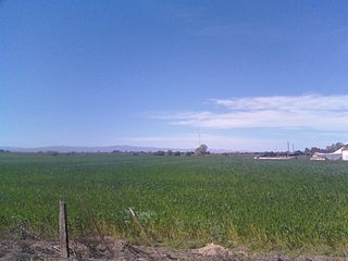
Riverdale Park is a census-designated place (CDP) in Stanislaus County, California, United States. The population was 1,128 at the 2010 census, up from 1,094 at the 2000 census. It is part of the Modesto Metropolitan Statistical Area.

<span class="mw-page-title-main">Poplar-Cotton Center, California</span> Census-designated place in California, United States

Poplar-Cotton Center is a census-designated place (CDP) in Tulare County, California, United States. The population was 2,470 at the 2010 census, up from 1,496 at the 2000 census.

<span class="mw-page-title-main">Inverness Highlands North, Florida</span> Census-designated place in Florida, US

Inverness Highlands North is an unincorporated area and census-designated place (CDP) in Citrus County, Florida, United States. The population was 2,401 at the 2010 census, up from 1,470 in 2000.

<span class="mw-page-title-main">Fairview Shores, Florida</span> Census-designated place in Florida, United States

Fairview Shores is a census-designated place and an unincorporated area in Orange County, Florida, United States. The population was 10,239 at the 2010 census. It is part of the Orlando–Kissimmee–Sanford, Florida Metropolitan Statistical Area.

<span class="mw-page-title-main">Desoto Lakes, Florida</span> Census-designated place in Florida, United States

Desoto Lakes is a census-designated place (CDP) in Sarasota County, Florida, United States. The population was 3,646 at the 2010 US Census. It is part of the Bradenton–Sarasota–Venice Metropolitan Statistical Area.

<span class="mw-page-title-main">Galena, Indiana</span> Census-designated place in Indiana, United States

Galena is a census-designated place (CDP) in Floyd County, Indiana, United States. The population was 1,818 at the 2010 census. The CDP includes the town of Galena as well as the nearby town of Floyds Knobs and their immediate surroundings.

Valley Station is a former census-designated place in southwest Jefferson County, Kentucky, United States. The population was 22,946 at the 2000 census. When the government of Jefferson County merged with the city of Louisville, Kentucky in 2003, residents of Valley Station also became citizens of Louisville Metro. As a result, Valley Station is said to be a neighborhood within the city limits of Louisville by local media. It was named for its location in the valley between Muldraugh Hill and the Knobs.

Brownsville-Bawcomville is a former census-designated place (CDP) in Ouachita Parish, Louisiana, United States. The population was 7,616 at the 2000 census. It is part of the Monroe Metropolitan Statistical Area. For the 2010 census, the U.S. Census Bureau split Brownsville-Bawcomville into its two constituent communities, Brownsville and Bawcomville.

<span class="mw-page-title-main">Stony Point, Michigan</span> Census-designated place & unincorporated community in Michigan, United States

Stony Point is an unincorporated community and census-designated place (CDP) in Monroe County in the U.S. state of Michigan. The population was 1,784 at the 2020 census. The CDP is located within Frenchtown Charter Township.

<span class="mw-page-title-main">Beechwood, Michigan</span> Census-designated place & Unincorporated community in Michigan, United States

Beechwood is an unincorporated community in Ottawa County in the U.S. state of Michigan. It is a census-designated place (CDP) for statistical purposes, but is not an incorporated municipality. The population was 3,121 at the 2020 census.

<span class="mw-page-title-main">Paradise, Montana</span> CDP in Montana, United States

Paradise is a census-designated place (CDP) in Sanders County, Montana, United States. The population was 166 at the 2020 census.

<span class="mw-page-title-main">Allenwood, New Jersey</span> Census-designated place in New Jersey, United States

Allenwood is an unincorporated community and census-designated place (CDP) located within Wall Township, in Monmouth County, New Jersey, United States. As of the 2010 United States Census, the CDP's population was 925.

<span class="mw-page-title-main">East Glenville, New York</span> Census-designated place in New York, United States

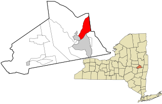
East Glenville is a hamlet in Schenectady County, New York, United States. The population was 6,616 at the 2010 census. The CDP includes the adjacent hamlet of Alplaus.

<span class="mw-page-title-main">Crystal Lakes, Ohio</span> Census-designated place in Ohio, United States

Crystal Lakes is a census-designated place (CDP) in Clark County, Ohio, United States. The population was 1,483 at the 2010 census. It is part of the Springfield, Ohio Metropolitan Statistical Area.

<span class="mw-page-title-main">Russellton, Pennsylvania</span> Census-designated place in Pennsylvania, United States

Russellton is a census-designated place (CDP) in Allegheny County, Pennsylvania, United States. The population was 1,440 at the 2010 census.

<span class="mw-page-title-main">Meadowood, Pennsylvania</span> Census-designated place in Pennsylvania, United States

Meadowood is a census-designated place (CDP) in Butler County, Pennsylvania, United States. The population was 2,693 at the 2010 census.

<span class="mw-page-title-main">Susquehanna Trails, Pennsylvania</span> CDP in Pennsylvania, United States

Susquehanna Trails is a census-designated place (CDP) in York County, Pennsylvania, United States. The population was 2,264 at the 2010 census.

<span class="mw-page-title-main">Shell Knob, Missouri</span> Census-designated place in Missouri, United States

Shell Knob is a census-designated place (CDP) located within White River Township, Barry County, Missouri. The population was 1,254 at the 2020 census.

References

  1. "ArcGIS REST Services Directory". United States Census Bureau. Retrieved October 12, 2022.
  2. 1 2 "Census Population API". United States Census Bureau. Retrieved Oct 12, 2022.
  3. "Census of Population and Housing". Census.gov. Retrieved June 4, 2016.
  4. "U.S. Census website". United States Census Bureau . Retrieved 2008-01-31.