Related Research Articles
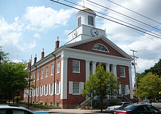
Bedford County is a county in the Commonwealth of Pennsylvania. As of the 2020 census, the population was 47,577. The county seat is Bedford.

Blair County is a county in the Commonwealth of Pennsylvania. As of the 2020 census, the population was 122,822. Its county seat is Hollidaysburg. The county was created on February 26, 1846, from parts of Huntingdon and Bedford counties.

Pavia Township is a township that is located in Bedford County, Pennsylvania, United States. The population was 284 at the time of the 2020 census.
Newry is a borough in Blair County, Pennsylvania, United States. The population was 231 at the 2020 census. It is part of the Altoona, PA Metropolitan Statistical Area and one of the communities comprising the Altoona Urban Area.

Roaring Spring is a borough in Blair County, Pennsylvania, United States. The population was 2,392 at the 2020 census. It is part of the Altoona, PA Metropolitan Statistical Area

Williamsburg in Morrisons Cove, is a borough in Blair County, Pennsylvania, United States. The population was 1,241 at the 2020 census. It is part of the Altoona, PA Metropolitan Statistical Area.
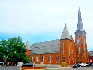
Huntingdon is a borough in Huntingdon County, Pennsylvania, United States. It is located along the Juniata River, approximately 32 miles (51 km) east of Altoona and 92 miles (148 km) west of Harrisburg. With a population of 7,093 at the 2010 census, it is the largest population center near Raystown Lake, a winding, 28-mile-long (45 km) flood-control reservoir managed by the U.S. Army Corps of Engineers.

A hairpin turn is a bend in a road with a very acute inner angle, making it necessary for an oncoming vehicle to turn about 180° to continue on the road. It is named for its resemblance to a bent metal hairpin. Such turns in ramps and trails may be called switchbacks in American English, by analogy with switchback railways.

Blue Knob State Park is a 6,128-acre (2,480 ha) Pennsylvania state park in Kimmel, Lincoln, and Pavia townships in Bedford County, Pennsylvania, in the United States. The average annual snowfall at the park is about 12 feet (370 cm). The park is named for Blue Knob, the second highest mountain in Pennsylvania at 3,146 feet (959 m). It is the location of Blue Knob All Seasons Resort, the ski slope in Pennsylvania with the highest elevation. Blue Knob State Park is just off Interstate 99 on Pennsylvania Route 869 west of Pavia.

The Frankstown Branch Juniata River is a 46.0-mile-long (74.0 km) tributary of the Juniata River in Blair and Huntingdon counties, Pennsylvania, in the United States.
Clover Creek is a 24.5-mile-long (39.4 km) tributary of the Frankstown Branch Juniata River in Bedford and Blair counties, Pennsylvania, in the United States.

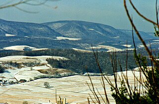
Wills Mountain is a quartzite-capped ridge in the Ridge and Valley physiographic province of the Appalachian Mountains in Pennsylvania and Maryland, United States, extending from near Bedford, Pennsylvania, to near Cumberland, Maryland. It is the northernmost of several mountain ridges included within the Wills Mountain Anticline.

Schaefer Head is a 2,950 feet (899 m) mountain in the Allegheny Mountains of Pennsylvania. It is one of the peaks that make up the Blue Knob massif, an isolated group of mountains that stand apart from the Allegheny Front. Schaefer Head is the third highest of these peaks behind Blue Knob 3,146 feet (959 m),and Herman Point 3,034 feet (925 m). Schaefer Head is also the highest point in Blair County.

The Silurian Tuscarora Formation — also known as Tuscarora Sandstone or Tuscarora Quartzite — is a mapped bedrock unit in Pennsylvania, Maryland, West Virginia, and Virginia, USA.
Pine Knob is a peak in the Allegheny Mountains of Pennsylvania. It is a satellite peak of its larger neighbor Blue Knob.

Blair Gap, one of the gaps of the Allegheny, is a water gap along the eastern face atop the Allegheny Front escarpment. Like other gaps of the Allegheny, the slopes of Blair Gap were amenable to foot travel, pack mules, and possibly wagons allowing Amerindians, and then, after about 1778-1780 settlers, to travel west into the relatively depopulated Ohio Country decades before the railroads were born and tied the country together with steel.
Culp is an unincorporated community located in Tyrone Township, Blair County, Pennsylvania, United States. It is located on Kettle Road at the intersection with Golf Course Road.
The Pennsylvania State Game Lands Number 26 are Pennsylvania State Game Lands in Bedford, Blair, Cambria, and Somerset Counties in Pennsylvania in the United States providing hunting, bird watching, equestrian, snowmobiling, and other activities.
Friesville is an unincorporated community and census-designated place (CDP) in Blair County, Pennsylvania, United States. It was first listed as a CDP prior to the 2020 census.
Ski Gap is a census-designated place (CDP) in Blair County, Pennsylvania, United States. It was first listed as a CDP prior to the 2020 census. The CDP corresponds to the unincorporated community of Fredericksburg, not to be confused with the Fredericksburg in the eastern part of Blair County.
References
- ↑ U.S. Geological Survey Geographic Names Information System: Puzzletown, Pennsylvania
- ↑ Africa, J. Simpson (1883). History of Huntingdon and Blair Counties, Pennsylvania. Louis H. Everts. p. 1.
