Tipton, Pennsylvania

Last updated

Tipton, Pennsylvania
Crazy Mouse DelRossos Amusement Park Tipton PA.jpg
Crazy Mouse ride at DelGrosso's Amusement Park
Map of Tipton, Blair County, Pennsylvania Highlighted.png
Location within Blair County
USA Pennsylvania location map.svg
Red pog.svg
Tipton
Location within the U.S. state of Pennsylvania
Coordinates: 40°38′8″N78°17′53″W / 40.63556°N 78.29806°W / 40.63556; -78.29806
Country United States
State Pennsylvania
County Blair
Township Antis
Area
[1]
  Total1.02 sq mi (2.64 km2)
  Land1.02 sq mi (2.64 km2)
  Water0.00 sq mi (0.00 km2)
Population
 (2020) [2]
  Total826
  Density809.01/sq mi (312.32/km2)
Time zone UTC-5 (Eastern (EST))
  Summer (DST) UTC-4 (EDT)
ZIP code
16684 [3]
Area code 814
FIPS code 42-76880

Tipton is a census-designated place (CDP) in Blair County, Pennsylvania, United States. The population was 1,083 at the 2010 census. It was a stop on the former Pennsylvania Railroad Main Line between Tyrone and Altoona.

Contents

Geography

Tipton is located at 40°38′8″N78°17′53″W / 40.63556°N 78.29806°W / 40.63556; -78.29806 (40.635659, -78.298034). [4]

According to the United States Census Bureau, the CDP has a total area of 1.9 square miles (4.9 km2), all land.

There are four unique sections to the Tipton area. The Poe, The Pellegrine, The Noel, and The Tilly regions, all named after the first settlers in the area. The Poe region consists of the north-eastern area, the Pellegrine region consists of the southern houses and apartments, and the Noel region consists of a small portion of land to the north-western area in which notable landmarks, such as the Tipton Recreation Center, are located. The Tilly region overlaps with the other three regions, and consists of the most of the factory's and manufacturing buildings.

Demographics

Historical population
CensusPop.Note
2020 826
U.S. Decennial Census [5] [2]

As of the census [6] of 2000, there were 1,225 people, 463 households, and 356 families residing in the CDP. The population density was 663.9 inhabitants per square mile (256.3/km2). There were 478 housing units at an average density of 259.1 per square mile (100.0/km2). The racial makeup of the CDP was 99.10% White, 0.16% African American, 0.41% Native American, and 0.33% from two or more races. Hispanic or Latino of any race were 0.33% of the population.

There were 463 households, out of which 33.5% had children under the age of 18 living with them, 67.4% were married couples living together, 5.6% had a female householder with no husband present, and 23.1% were non-families. 19.2% of all households were made up of individuals, and 8.9% had someone living alone who was 65 years of age or older. The average household size was 2.65 and the average family size was 3.03.

In the CDP, the population was spread out, with 23.8% under the age of 18, 7.3% from 18 to 24, 28.7% from 25 to 44, 25.0% from 45 to 64, and 15.2% who were 65 years of age or older. The median age was 40 years. For every 100 females, there were 100.8 males. For every 100 females age 18 and over, there were 101.9 males.

The median income for a household in the CDP was $51,250, and the median income for a family was $59,100. Males had a median income of $37,596 versus $28,359 for females. The per capita income for the CDP was $21,320. About 6.0% of families and 12.0% of the population were below the poverty line, including 19.9% of those under age 18 and 13.5% of those age 65 or over.

Related Research Articles

<span class="mw-page-title-main">South Oroville, California</span> Census-designated place in California, United States

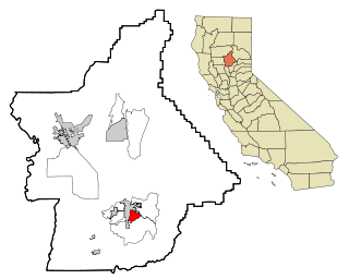
South Oroville is a census-designated place (CDP) in Butte County, California, United States. The population was 5,742 at the 2010 census, down from 7,695 at the 2000 census.

<span class="mw-page-title-main">Tipton, California</span> Census-designated place in California, United States

Tipton is a census-designated place (CDP) in Tulare County, California, United States. The population was 2,543 at the 2010 census, up from 1,790 at the 2000 census.

<span class="mw-page-title-main">Wright, Florida</span> Census-designated place in Florida

Wright is a census-designated place (CDP) in Okaloosa County, Florida, United States. The population was 23,127 at the 2010 United States Census. It is part of the Fort Walton Beach–Crestview–Destin Metropolitan Statistical Area.

<span class="mw-page-title-main">Burnham, Illinois</span> Village in Illinois, United States

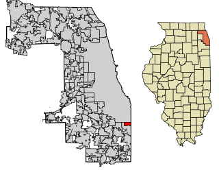
Burnham is a village in Cook County, Illinois, United States. The population was 4,046 at the 2020 census. The ZIP code is 60633.

<span class="mw-page-title-main">Eagle, New York</span> Town in New York, United States

Eagle is an incorporated town in Wyoming County, New York. The population was 1,194 at the 2000 census. The town is on the south border of the county.

<span class="mw-page-title-main">Beaverdale, Pennsylvania</span> Census-designated place in Pennsylvania, United States

Beaverdale is an unincorporated community and census-designated place (CDP) in Cambria County, Pennsylvania, United States. The population was 1,035 at the 2010 census. Prior to that time, the CDP was known as Beaverdale-Lloydell.

<span class="mw-page-title-main">Belmont, Pennsylvania</span> Census-designated place in Pennsylvania, United States

Belmont is an unincorporated community and census-designated place (CDP) in Cambria County, Pennsylvania, United States. The population was 2,784 at the 2010 census.

<span class="mw-page-title-main">Elim, Pennsylvania</span> Census-designated place in Pennsylvania, United States

Elim is an unincorporated community and census-designated place (CDP) in Upper Yoder Township, Cambria County, Pennsylvania, United States. The population was 3,727 at the 2010 census, down from 4,175 at the 2000 census.

<span class="mw-page-title-main">Salix, Pennsylvania</span> Census-designated place in Pennsylvania, United States

Salix is an unincorporated community and census-designated place (CDP) in Cambria County, Pennsylvania, United States. The population was 1,149 at the 2010 census. In previous censuses it was listed as Salix-Beauty Line Park.

<span class="mw-page-title-main">Spring Hill, Pennsylvania</span>

Spring Hill is a census-designated place (CDP) in Cambria County, Pennsylvania, United States. The population was 839 at the 2010 census, down from 970 at the 2000 census.

<span class="mw-page-title-main">St. Michael-Sidman, Pennsylvania</span> Former CDP in Pennsylvania, United States

St. Michael-Sidman was a census-designated place (CDP) in Cambria County, Pennsylvania, United States. The population was 973 at the 2000 census. For the 2010 census, the area was split into two CDPs, St. Michael and Sidman.

<span class="mw-page-title-main">Sandy, Pennsylvania</span> Census-designated place in Pennsylvania, United States

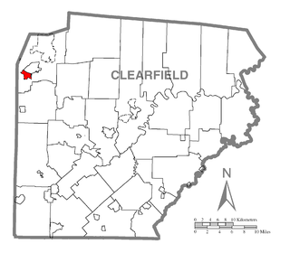
Sandy is a census-designated place (CDP) in Clearfield County, Pennsylvania, United States. The population was 1,362 at the 2020 census.

<span class="mw-page-title-main">Wilburton Number Two, Pennsylvania</span> Census-designated place in Pennsylvania, United States

Wilburton Number Two is a census-designated place (CDP) in Columbia County, Pennsylvania, United States. It is part of Northeastern Pennsylvania. The population was 96 at the 2010 census. It is part of the Bloomsburg-Berwick micropolitan area.

Heilwood is a census-designated place (CDP) in Indiana County, Pennsylvania, United States. The population was 711 at the time of the 2010 census.

<span class="mw-page-title-main">Montgomeryville, Pennsylvania</span> Census-designated place in Pennsylvania, United States

Montgomeryville is a census-designated place (CDP) in Montgomery Township, Montgomery County, Pennsylvania, United States. The population was 12,624 at the 2010 census. According to a 2010 Forbes magazine/Yahoo.com survey, Montgomeryville ranks 5th in America's top 10 affordable suburbs. It is part of the North Penn Valley region that is centered on the borough of Lansdale.

Friedens is a census-designated place (CDP) that is part of Somerset Township in Somerset County, Pennsylvania, United States. The population was 1,523 at the 2010 census. It is part of the Johnstown, Pennsylvania Metropolitan Statistical Area.

Loyalhanna is a census-designated place (CDP) in Westmoreland County, Pennsylvania, United States. The population was 3,415 at the 2000 census, at which time it was listed as McChesneytown-Loyalhanna, before just becoming the CDP of Loyalhanna for the 2010 census. As of the 2010 census the population was 3,428 residents.

<span class="mw-page-title-main">Dooms, Virginia</span> CDP in Virginia, United States

Dooms is a census-designated place (CDP) in Augusta County, Virginia, United States. The population was 1,327 at the 2010 census. It is part of the Staunton–Waynesboro Micropolitan Statistical Area.

<span class="mw-page-title-main">Barre (CDP), Massachusetts</span> CDP in Massachusetts, United States

Barre is a census-designated place (CDP) in the town of Barre in Worcester County, Massachusetts, United States. The population was 1,009 at the 2010 census.

<span class="mw-page-title-main">Warren (CDP), Massachusetts</span> CDP in Massachusetts, United States

Warren is a census-designated place (CDP) in the town of Warren in Worcester County, Massachusetts, United States. The population was 1,405 at the 2010 census.

References

  1. "ArcGIS REST Services Directory". United States Census Bureau. Retrieved October 15, 2022.
  2. 1 2 "Census Population API". United States Census Bureau. Retrieved October 15, 2022.
  3. "Tipton PA ZIP Code". zipdatamaps.com. 2023. Retrieved June 27, 2023.
  4. "US Gazetteer files: 2010, 2000, and 1990". United States Census Bureau. February 12, 2011. Retrieved April 23, 2011.
  5. "Census of Population and Housing". Census.gov. Retrieved June 4, 2016.
  6. "U.S. Census website". United States Census Bureau . Retrieved January 31, 2008.