Clinton, Kansas

Last updated

Clinton, Kansas
Clinton Store.JPG
"the Clinton Store" in Clinton (2008)
Map of Douglas Co, Ks, USA.png
USA Kansas location map.svg
Red pog.svg
Clinton
Usa edcp location map.svg
Red pog.svg
Clinton
Coordinates: 38°54′42″N95°23′26″W / 38.91167°N 95.39056°W / 38.91167; -95.39056 [1]
Country United States
State Kansas
County Douglas
Elevation
[1]
935 ft (285 m)
Time zone UTC-6 (CST)
  Summer (DST) UTC-5 (CDT)
Area code 785
FIPS code 20-14300 [1]
GNIS ID 479107 [1]

Clinton is an unincorporated community on a peninsula next to Clinton Lake in Douglas County, Kansas, United States. [1]

Contents

History

Bloomington

The community of Bloomington was settled in June 1854 but was not called as such until April 1855 when Harrison Burson applied to the U.S. Government for a post office. Within eight months of the area being settled some 530 settlers were in the area that would become Bloomington-Clinton. The people of Bloomington were greatly anti-slavery and helped slaves escape through the Underground Railroad. In early 1857, the north half of Bloomington was moved to a new location and the south portion of the community was renamed Winchester.

Winchester

Winchester was named after a city in Illinois as was Bloomington. Later in the year Bloomington acted to become an incorporated city with Winchester following suit four days later. Winchester was incorporated on February 20, 1857, under the name of Clinton. The present name is after Clinton, Illinois. [2]

Clinton

Clinton and Bloomington quickly became rivals since they were only separated by about three miles. Bloomington started losing ground in 1858 when on August 30, the post office was moved to Clinton. Within the first five years of existence, Clinton constructed two schoolhouses, two churches and a town hall. In 1869, the Clinton Cemetery was established on land already used for a cemetery and is considered one of the oldest burial grounds in Douglas County.

The Wakarusa River Valley Heritage Museum near Clinton. Wakarusa Valley Museum.JPG
The Wakarusa River Valley Heritage Museum near Clinton.

The Lawrence & Emporia Railroad was constructed through Bloomington and Clinton in 1873 but its route was soon rendered redundant by larger competing railroads and it was abandoned by 1894. In 1876, most of Bloomington had reverted into farmland and was considered vacated.

The post office in Clinton closed in 1927. [3]

Starting in the mid-1960s, land was purchased for the construction of Clinton Lake and the entire town of Bloomington was bulldozed leaving only the J.C. Steele house and a milk shed standing. The house was placed on the National Register of Historic Places in 1979, but was later razed, leaving only the foundations and the stairs. [4] The shed still stands as the Clinton Lake Museum near Bloomington Beach in the Bloomington Recreation Area.

Bleeding Kansas

In August 1856, the Lawrence supply route was cut off and the townspeople were forced to travel to Lecompton which was strongly pro-slavery. Henry Hiatt and several other people were taken prisoner and fifty proslavery ruffians began marching to Bloomington. A team of 400 or 800 men marched toward Lecompton and although a confrontation was avoided it resulted in the looting and burning of Colonel Henry T. Titus home (known as the Battle of Fort Titus).

A splinter group from William Quantrill's raid on Lawrence in 1863 rode through Bloomington but caused more damage and harm when passing through Lone Star which is about five miles south of Clinton.

Education

The community is served by Lawrence USD 497 public school district.

Related Research Articles

<span class="mw-page-title-main">Douglas County, Kansas</span> County in Kansas, United States

Douglas County is located in the U.S. state of Kansas. Its county seat and most populous city is Lawrence. As of the 2020 census, the county population was 118,785, making it the fifth-most populous county in Kansas. The county was named after Stephen Douglas, a U.S. Senator from Illinois and advocate for the moderate popular sovereignty choice in the Kansas slavery debate.

<span class="mw-page-title-main">Lawrence, Kansas</span> City and County seat in Kansas, United States

Lawrence is the county seat of Douglas County, Kansas, United States, and the sixth-largest city in the state. It is in the northeastern sector of the state, astride Interstate 70, between the Kansas and Wakarusa Rivers. As of the 2020 census, the population of the city was 94,934. Lawrence is a college town and the home to both the University of Kansas and Haskell Indian Nations University.

<span class="mw-page-title-main">Lecompton, Kansas</span> City in Kansas, United States

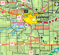
Lecompton is a city in Douglas County, Kansas, United States. As of the 2020 census, the population of the city was 588. Lecompton was the de jure territorial capital of Kansas from 1855 to 1861, and the Douglas County seat from 1855 to 1858. Anti-slavery Lawrence became the de facto capital during the latter part of this period, when the county seat was moved there. This time period was known as Bleeding Kansas, due to the violence perpetrated by the pro-slavery, and to a lesser extent the anti-slavery, factions in the eastern part of the state. Lecompton was a hotbed of pro-slavery sentiment during the mid-1800s.

<span class="mw-page-title-main">Bleeding Kansas</span> Violent slavery-related confrontations in Kansas territory in latter half of 1850s

Bleeding Kansas, Bloody Kansas, or the Border War was a series of violent civil confrontations in Kansas Territory, and to a lesser extent in western Missouri, between 1854 and 1859. It emerged from a political and ideological debate over the legality of slavery in the proposed state of Kansas.

<span class="mw-page-title-main">Lecompton Constitution</span>

The Lecompton Constitution (1858) was the second of four proposed constitutions for the state of Kansas. Named for the city of Lecompton where it was drafted, it was strongly pro-slavery. It never went into effect.

<span class="mw-page-title-main">Clinton Lake (Kansas)</span> Large artificial lake located in Douglas County Kansas

Clinton Lake is a reservoir on the southwestern edge of Lawrence, Kansas. The lake was created by the construction of the Clinton Dam, and the 35 square miles (91 km2) of land and water is maintained by the U.S. Army Corps of Engineers.

<span class="mw-page-title-main">Stull, Kansas</span> Unincorporated community in Kansas, United States

Stull is an unincorporated community in Douglas County, Kansas, United States. Founded in 1857, the settlement was initially known as Deer Creek until it was renamed after its only postmaster, Sylvester Stull. As of 2018, only a handful of structures remain in the area.

<span class="mw-page-title-main">Richland, Kansas</span> Ghost town in Kansas, United States

Richland is currently a ghost town in southeastern Shawnee County, Kansas, United States.

<span class="mw-page-title-main">Big Springs, Kansas</span> Unincorporated community in Kansas, United States

Big Springs is an unincorporated community in northwest Douglas County, Kansas, United States.

<span class="mw-page-title-main">Prairie City, Kansas</span> Ghost town in Kansas, United States

Prairie City is a ghost town in southeast Douglas County, Kansas, United States, near present-day Baldwin City.

<span class="mw-page-title-main">Clinton Township, Douglas County, Kansas</span> Township in Kansas, United States

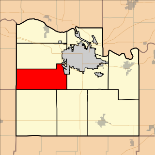
Clinton Township is a township in Douglas County, Kansas, USA. As of the 2000 census, its population was 531. It took its name from Clinton, Illinois.

<span class="mw-page-title-main">Lecompton Township, Douglas County, Kansas</span> Township in Kansas, United States

Lecompton Township is a township in Douglas County, Kansas, USA. As of the 2000 census, its population was 1,761.

<span class="mw-page-title-main">Wakarusa Township, Douglas County, Kansas</span> Township in Kansas, United States

Wakarusa Township is a township in Douglas County, Kansas, USA. As of the 2010 census, its population was 2,318. It was named for the Wakarusa River which flows through Douglas County from Wabaunsee County to the Kansas River near Eudora.

<span class="mw-page-title-main">Constitution Hall (Lecompton, Kansas)</span> United States historic place

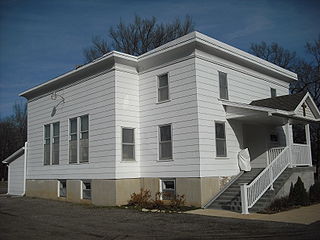
Lecompton Constitution Hall, also known as Constitution Hall, is a building in Lecompton, Kansas, that played an important role in the long-running Bleeding Kansas crisis over slavery in Kansas. It is operated by the Kansas Historical Society as Constitution Hall State Historic Site.

<span class="mw-page-title-main">Lone Star, Kansas</span> Unincorporated community in Kansas, United States

Lone Star is an unincorporated community in Douglas County, Kansas, United States. It is located 7 miles (11 km) southwest of Lawrence.

<span class="mw-page-title-main">John Henry Kagi</span> American lawyer

John Henry Kagi, also spelled John Henri Kagi, was an American attorney, abolitionist, and second in command to John Brown in Brown's failed raid on Harper's Ferry. He bore the title of "Secretary of War" in Brown's "provisional government." At age 24, Kagi was killed during the raid. He had previously been active in fighting on the abolitionist side in 1856 in "Bleeding Kansas". He was an excellent debater and speaker.

Franklin is a ghost town in Douglas County, Kansas, United States. Established as a proslavery stronghold, the town played a key role in the "Bleeding Kansas" conflict that troubled the territory in the 1850s.

The Battle of Fort Titus was a battle that occurred during conflicts in the Kansas Territory between abolitionist and pro-slavery militias prior to the American Civil War. The era is known as Bleeding Kansas.

<span class="mw-page-title-main">Samuel J. Jones</span> American frontier settler

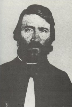
Samuel Jefferson Jones was a pro-slavery settler who held the position of Douglas County sheriff in Kansas Territory from late 1855 until early 1857. He helped found the territorial capital of Lecompton and played a prominent role in the "Bleeding Kansas" conflict.

References

  1. 1 2 3 4 5 "Clinton, Kansas", Geographic Names Information System , United States Geological Survey, United States Department of the Interior
  2. Carpenter, Tim (November 28, 1997). "What's in a name? Key elements of area history". Lawrence Journal-World. pp. 3B. Retrieved April 28, 2015.
  3. "Kansas Post Offices, 1828-1961 (archived)". Kansas Historical Society. Archived from the original on March 10, 2013. Retrieved June 8, 2014.
  4. Hall, Brian (March 29, 2014). "The J.C. Steele House". Tauy Creek. The Point of Beginning. Retrieved April 27, 2018.

Further reading