
Kansas is a landlocked state in the Midwestern region of the United States. It borders Nebraska to the north; Missouri to the east; Oklahoma to the south; and Colorado to the west. Kansas is named after the Kansas River, in turn named after the Kansa people. Its capital is Topeka, and its most populous city is Wichita, however the largest urban area is the bi-state Kansas City, MO–KS metropolitan area.

Topeka is the capital city of the U.S. state of Kansas and the seat of Shawnee County. It is along the Kansas River in the central part of Shawnee County, in northeast Kansas, in the Central United States. As of the 2020 census, the population of the city was 126,587. The Topeka metropolitan statistical area, which includes Shawnee, Jackson, Jefferson, Osage, and Wabaunsee Counties, had a population of 233,870 in the 2010 census.

Washington County is a county located in the northeastern part of the U.S. state of Oklahoma. As of the 2020 census, the population was 52,455. Its county seat is Bartlesville. Named for President George Washington, it is the smallest county in Oklahoma in total area, adjacent to the largest county in Oklahoma, Osage County.

Douglas County is located in the U.S. state of Kansas. Its county seat and most populous city is Lawrence. As of the 2020 census, the county population was 118,785, making it the fifth-most populous county in Kansas. The county was named after Stephen Douglas, a U.S. Senator from Illinois and advocate for the popular sovereignty choice in the Kansas slavery debate.

Strong City is a city in Chase County, Kansas, United States. Originally known as Cottonwood Station, in 1881 it was renamed Strong City after William Barstow Strong, then vice-president and general manager, and later president of the Atchison, Topeka and Santa Fe Railway. As of the 2020 census, the population of the city was 386. It is located along U.S. Route 50 highway.

Lawrence is a city in and the county seat of Douglas County, Kansas, United States, and the sixth-largest city in the state. It is in the northeastern sector of the state, astride Interstate 70, between the Kansas and Wakarusa Rivers. As of the 2020 census, the population of the city was 94,934. Lawrence is a college town and the home to both the University of Kansas and Haskell Indian Nations University.

The Midland Railway was a heritage railroad operating 16 miles of line in Franklin County and Douglas County in Kansas between Ottawa, Kansas and Baldwin City, Kansas.
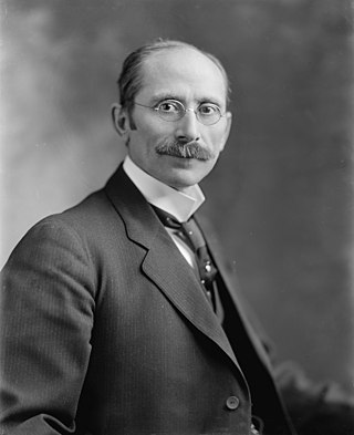
Joseph Little Bristow was a Republican politician from the American state of Kansas. Elected in 1908, Bristow served a single term in the United States Senate where he gained recognition for his support of several political causes of the Progressive era. In retirement, Bristow was a farmer in Annandale, Virginia.

The Battle of Black Jack took place on June 2, 1856, when antislavery forces, led by the noted abolitionist John Brown, attacked the encampment of Henry C. Pate near Baldwin City, Kansas. The battle is cited as one incident of "Bleeding Kansas" and a contributing factor leading up to the American Civil War of 1861 to 1865.

Pauline is an unincorporated community in Shawnee County, Kansas, United States. Located south of Topeka, it lies next to Forbes Field on southwest Topeka Boulevard. It is occasionally seen as part of the South City Industry Park for Topeka with its many large businesses.

Stull is an unincorporated community in Douglas County, Kansas, United States. Founded in 1857, the settlement was initially known as Deer Creek until it was renamed after its only postmaster, Sylvester Stull. As of 2018, only a handful of structures remain in the area.

Twin Mound is a ghost town in western Douglas County, Kansas, United States. It was named for two natural mounds that rise gently from the landscape.
Homestead Township is a township in Chase County, Kansas, United States. As of the 2000 census, its population was 52.
Greenwood Township is a township in Franklin County, Kansas, United States-. As of the 2000 census, its population was 429.
The following is a timeline of the history of Topeka, Kansas, USA.

Oursler is a ghost town in Marion County, Kansas, United States. It is currently a ghost town that was located approximately 3.5 miles southeast of Marion next to a former railroad. No buildings remain of this former community.
Franklin is a ghost town in Douglas County, Kansas, United States. Established as a proslavery stronghold, the town played a key role in the "Bleeding Kansas" conflict that troubled the territory in the 1850s.
Franklin's Fort was a small fortification that had been erected in Franklin, Douglas County, Kansas by pro-slavery settlers. During the "Bleeding Kansas" period, the fort was the site of two minor battles between pro- and anti-slavery factions.
Jay S. Parker was a justice of the Kansas Supreme Court from January 11, 1943, to January 14, 1957, serving as chief justice from January 14, 1957 to May 1, 1966.


