Oakland County is a county in the U.S. state of Michigan. It is a principal county of the Detroit metropolitan area, containing the bulk of Detroit's northern suburbs. The county seat is Pontiac. As of the 2020 Census, its population was 1,274,395, making it the second-most populous county in Michigan, and the largest county in the United States without a city of 100,000 residents.

Macomb County is a county located in the eastern portion of the U.S. state of Michigan, bordering Lake St. Clair, and is part of northern Metro Detroit. As of the 2020 Census, the population was 881,217, making it the third-most populous county in the state. The county seat is Mt. Clemens. Macomb County is part of the Detroit-Warren-Dearborn, MI Metropolitan Statistical Area. The city of Detroit is located south of the county's southern border. Macomb County contains 27 cities, townships and villages, including three of the top ten most-populous municipalities in Michigan as of the 2010 census: Warren (#3), Sterling Heights (#4) and Clinton Township (#10). Most of this population is concentrated south of Hall Road (M-59), one of the county's main thoroughfares.
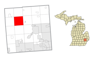
Springfield Charter Township is a charter township of Oakland County in the U.S. state of Michigan. As of the 2010 census, the township population was 13,940. The township was named for the numerous springs in the area.
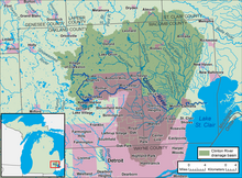
The St. Clair River is a 40.5-mile-long (65.2 km) river in central North America which flows from Lake Huron into Lake St. Clair, forming part of the international boundary between Canada and the United States and between the Canadian province of Ontario and the U.S. state of Michigan. The river is a significant component in the Great Lakes Waterway, whose shipping channels permit cargo vessels to travel between the upper and lower Great Lakes.

The Clinton–Kalamazoo Canal is a canal in Michigan that was abandoned after being only partially completed. The canal was to connect Lake St. Clair with Lake Michigan. Project backers were inspired by the success of the Erie Canal in New York, which was completed in 1825. After gaining statehood in 1837, Michigan elected its first governor, Stevens Thomson Mason, who initiated an ambitious program of internal improvements, including three railroads and two canals. On March 21, 1837, the Legislature authorized Governor Mason to contract a loan for the construction of the canal from Mt. Clemens to Rochester, a railroad from Shelby to Detroit, a railroad from Detroit across the State and a railroad from Port Huron into the interior, to be known as the Port Huron & Grand River road. In the spring of 1838, a Board of Commissioners composed of seven men, was appointed to take charge of the canal work.

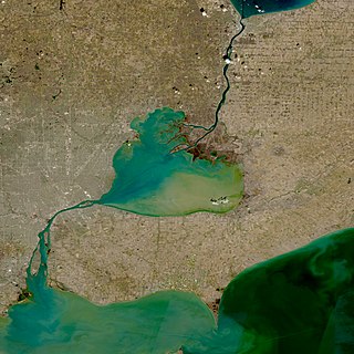
Lake St. Clair is a freshwater lake that lies between the Canadian province of Ontario and the U.S. state of Michigan. It was named in 1679 by French Catholic explorers after Saint Clare of Assisi, on whose feast day they first saw the lake.

Metro Detroit is a major metropolitan area in the U.S. state of Michigan, consisting of the city of Detroit and over 200 municipalities in the surrounding area. There are varied definitions of the area, including the official statistical areas designated by the Office of Management and Budget, a federal agency of the United States.

The Huron River is a 130-mile-long (210 km) river in southeastern Michigan, rising out of the Huron Swamp in Springfield Township in northern Oakland County and flowing into Lake Erie, as it forms the boundary between present-day Wayne and Monroe counties. Thirteen parks, game areas, and recreation areas are associated with the river, which passes through the cities of Dexter, Ann Arbor, Ypsilanti, Belleville, Flat Rock and Rockwood that were developed along its banks.
The Thumb is a region and a peninsula of the U.S. state of Michigan, so named because the Lower Peninsula is shaped like a mitten. The Thumb area is generally considered to be in the Central Michigan region, east of the Tri-Cities and north of Metro Detroit. The region is also branded as the Blue Water Area.
Lake St. Clair Metropark/Metro Beach Metropark is a 770-acre unit of the Huron-Clinton Metroparks system located roughly 20 miles (32 km) northeast of downtown Detroit, Michigan in Harrison Township, Macomb County. Lake St. Clair Metropark has been in existence since 1950 and has seen many changes since then. Originally named St. Clair Metropolitan Beach, it was renamed in 1953 to Metropolitan Beach Metropark and later shortened to Metro Beach Metropark. On December 8, 2011, the Board of Commissioners for the Huron-Clinton Metroparks approved changing the name to Lake St. Clair Metropark. The park is located at Jefferson Avenue and Metropolitan Parkway and there are signs to Lake St. Clair Metropark on Interstate 94 (I-94).

The Huron–Clinton Metroparks system is a regional park system in Metro Detroit in the U.S. state of Michigan. The park system includes 13 parks totaling more than 24,000 acres (97 km2) arranged along the Huron River and Clinton River forming a partial ring around the metro area. Plans are in development to finish the ring by building hike/bike trails to connect all the parks as a green belt. The parks draw about 7.5 million visitors a year, down from a peak of 10 million in 2009. The park system is primarily tax-funded with a $50 million annual budget. The system provides employment for 200 full-time and part-time employees year-round and 1,000 additional summer workers. The rivers are prime fishing and canoeing streams with Delhi Metropark including a short rapids, which while runnable, is the only point other than dams on either stream normally portaged.
The Belle River is a 73.5-mile-long (118.3 km) river in the U.S. state of Michigan, flowing into the St. Clair River in Marine City at 42°42′25″N82°29′50″W.

Southeast Michigan, also called southeastern Michigan, is a region in the Lower Peninsula of Michigan that is home to a majority of the state's businesses and industries as well as slightly over half of the state's population, most of whom are concentrated in Metro Detroit.
Stony Creek Metropark is a Huron-Clinton Metropark located in southeast Michigan in the outskirts of metro Detroit. The park is predominantly in Washington Township and Oakland Township, with a small portion in Shelby Township. The park covers 4,461 acres (18.05 km2) with Stony Creek Lake at its center.

The Nottawaseppi Huron Band of Potawatomi (NHBP) is a federally-recognized tribe of Potawatomi in the United States. The tribe achieved federal recognition on December 19, 1995, and currently has approximately 1500 members.
The Huron Swamp is a heavily forested wetland located in Springfield Township, in Michigan's Oakland County. It is nine miles northwest of the city of Pontiac. It is part of the local Indian Springs Metropark, which is then a component of the Huron-Clinton Metroparks system. Big Lake is to the northwest.

Lake Erie Basin consists of Lake Erie and surrounding watersheds, which are typically named after the river, creek, or stream that provides drainage into the lake. The watersheds are located in the states of Indiana, Michigan, New York, Ohio, and Pennsylvania in the United States, and in the province of Ontario in Canada. The basin is part of the Great Lakes Basin and Saint Lawrence River Watershed, which feeds into the Atlantic Ocean. 80% of the lake's water flows in from the Detroit River, with only 9% coming from all of the remaining watersheds combined. A littoral zone serves as the interface between land and lake, being that portion of the basin where the lake is less than 15 feet (4.6 m) in depth.

The Detroit metropolitan area in southeast Michigan is served by a comprehensive network of roads and highways. Three primary Interstate Highways pass through the region, along with three auxiliary Interstates, and multiple state and U.S. Highways. These are supplemented by the Mile Road System, a series of local roads spaced one mile apart on a perpendicular grid.
Anchor Bay is a freshwater bay forming the northern region of Lake St. Clair in the U.S. state of Michigan. It generally encompasses the waters north of a line between Huron Point and the Middle Channel of the St. Clair River. It covers over 90 square miles (230 km2) and a depth of from 1 to 11 feet, which is unusually shallow for its immense size.