Wyandot County is a county located in the northwestern part of the U.S. state of Ohio. As of the 2010 census, the population was 22,615. Its county seat is Upper Sandusky. It was named for the Wyandot Indians, who lived here before and after European encounter. Their autonym is variously translated from their language as "around the plains" and "dwellers on the peninsula".

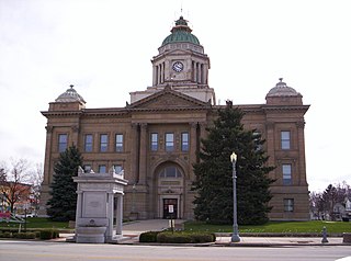
Upper Sandusky is a city and the county seat of Wyandot County, Ohio, United States, along the upper Sandusky River, which flows north to Sandusky Bay and Lake Erie. The city is approximately 59 mi (96 km) south of Toledo and 62 mi (99 km) north of Columbus. The population was 6,596 at the 2010 census. The city was founded in 1843 and named for an earlier Wyandot Indian village of the same name, which was located nearby. It was named "Upper" because it is located near the headwaters of the Sandusky River;

The Gnadenhutten massacre, also known as the Moravian massacre, was the killing of 96 Christian Lenape by U.S. militiamen from Pennsylvania on March 8, 1782 at the Moravian missionary village of Gnadenhutten, Ohio, during the American Revolutionary War. More than a century later, Theodore Roosevelt called the massacre "a stain on frontier character that the lapse of time cannot wash away."

William Crawford was an American soldier and surveyor who worked as a western land agent for George Washington. Crawford fought in the French and Indian War and the American Revolutionary War. He was tortured and burned at the stake by American Indians in retaliation for the Gnadenhutten massacre, a notorious slaughter of Indians by militia near the end of the American Revolution.

The Western theater of the American Revolutionary War (1775–1783) was the area of conflict west of the Appalachian Mountains, the region which became the Northwest Territory of the United States as well as the states of Kentucky, Tennessee, Missouri and Spanish Louisiana. The western war was fought between American Indians with their British allies in Detroit, and American settlers south and east of the Ohio River, and also the Spanish as allies of the latter.

The Battles of Frenchtown, also known as the Battle of the River Raisin and the River Raisin Massacre, were a series of conflicts in Michigan Territory that took place from January 18–23, 1813, during the War of 1812. It was fought between the United States and a British and Native American alliance near the River Raisin in Frenchtown,.
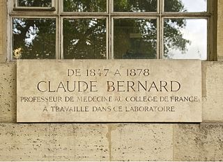
A commemorative plaque, or simply plaque, or in other places referred to as a historical marker or historic plaque, is a plate of metal, ceramic, stone, wood, or other material, typically attached to a wall, stone, or other vertical surface, and bearing text or an image in relief, or both, to commemorate one or more persons, an event, a former use of the place, or some other thing. Many modern plaques and markers are used to associate the location where the plaque or marker is installed with the person, event, or item commemorated as a place worthy of visit. A monumental plaque or tablet commemorating a deceased person or persons, can be a simple form of church monument. Most modern plaques affixed in this way are commemorative of something, but this is not always the case, and there are purely religious plaques, or those signifying ownership or affiliation of some sort. A plaquette is a small plaque, but in English, unlike many European languages, the term is not typically used for outdoor plaques fixed to walls.

Fort Stephenson was built in the early 1800s on the west side of the lower Sandusky River. It was the site in 1813 of an American victory in the Battle of Fort Stephenson during the War of 1812.

The Big Bottom massacre occurred on January 2, 1791, near present-day Stockport now in Morgan County, Ohio, United States. It is considered part of the Northwest Indian Wars, in which aboriginal Americans in the Ohio Country confronted American settlers, regular soldiers and militia, seeking to expel them from their territory.
Wakatomika was the name of two 18th century Shawnee villages in what is now the U.S. state of Ohio. The name was also spelled Wapatomica, Waketomika, and Waketameki, among other variations, but the similar name Wapakoneta was a different Shawnee village.
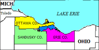
Sandusky Bay is a bay on Lake Erie in northern Ohio, formed at the mouth of the Sandusky River. It was identified as Lac Sandouské on a 1718 French map, with early variations recorded that suggest the name was derived from Native American languages. The Thomas A. Edison Memorial Bridge was constructed across it in the 20th century to connect highways in Erie and Ottawa counties.

The Crawford expedition, also known as the Sandusky expedition and Crawford's Defeat, was a United States campaign from May to June of 1782 on the western front of the American Revolutionary War, and one of the final operations of the conflict. Led by Colonel William Crawford, the campaign's goal was to destroy enemy Native American towns along the Sandusky River in the Ohio Country, with the hope of ending Indian attacks on American settlers. The expedition was one in a long series of raids against enemy settlements which both sides had conducted throughout the war.

John B. McClelland (1734–1782) was an officer in the American Revolutionary War. He was captured by American Indians during the Crawford Expedition and tortured to death at the Shawnee town of Wakatomika, which is currently located in Logan County, Ohio, about halfway between West Liberty, Ohio and Zanesfield, Ohio.
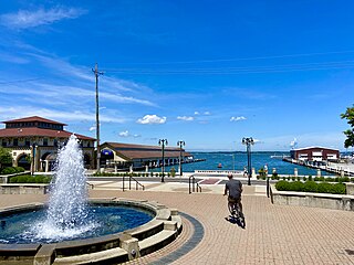
Sandusky is a city in the U.S. state of Ohio and the county seat of Erie County. Situated in northern Ohio on the shores of Lake Erie, Sandusky is midway between Toledo to the west and Cleveland to the east.
David Williamson (1752–1814) was a Colonel in the Pennsylvania militia during the American Revolutionary War. He was born near Carlisle, Pennsylvania. He led the expedition that murdered 100 Moravian Delaware Indians at the town of Gnadenhutten, Ohio. It became known as the Gnadenhutten massacre. He was also second in command of the Crawford expedition which was defeated by the combined Native American and British force at the Battle of Sandusky on June 4–6, 1782 near the Wyandot village of Upper Sandusky, Ohio. He led the majority of the remaining force home and was in command during the subsequent Battle of Olentangy during the retreat home on June 6, 1782. Following the war, Williamson was elected to several terms as Sheriff of Washington County, Pennsylvania; however, his attempts at various business ventures failed and he died in poverty in 1814.
Gustavus Heinrich de Rosenthal (1753–1829) was a Baltic German soldier and member of the Baltic nobility born in Vaimõisa, present-day Estonia, with the Title of Baron and last name of von Wetter-Rosenthal, a junior line of the von Wetter-Tegenfeldens. He came into conflict with another man and was forced to flee the country after killing him in a duel. He came to North America, where he served in the Continental Army using the name John Rose.

Thomas Gaddis (1742–1834) was an officer in the American Revolutionary War. He was born December 28, 1742, in Winchester, Frederick County, Virginia and married Hannah Rice in 1764; the same year he built Fort Gaddis, a refuge from the Indians, located on the Catawba Trail. In fact, Pennsylvania and Virginia had conflicting claims in the area Gaddis settled. Though he maintained his loyalty to Virginia, Gaddis also protected his investment by recording his patent with Pennsylvania authorities. By 1773, both states created new geo-political boundaries in recognition of increased white settlement. Pennsylvania formed Westmoreland County out of the larger Bedford County, and Virginia established the District of West Augusta. In 1776, West Augusta was further divided into three counties: Ohio, Youghiogheny, and Monongahela, where Gaddis and his family resided.
Roundhead, also known as Bark Carrier, Round Head, Stayeghtha, and Stiahta, was an American Indian chief of the Wyandot tribe. He was a strong member of Tecumseh's confederacy against the United States during the War of 1812. He died of unknown natural causes about a month or two before Tecumseh was killed at the Battle of the Thames.
James Brenton (1740–1782) was an American Revolutionary War officer. He was killed by American Indians during the Battle of Blue Licks in Robertson County, Kentucky. He married Rebecca Scott (1740-1771) abt. 1763 in Frederick County, Virginia, and then married Mary Woodfield in 1772, Westmoreland County, Pennsylvania.


