Commonwealth Connections

Last updated
Commonwealth Connections logo Commonwealth Connections.png
Commonwealth Connections logo

Commonwealth Connections is a greenway and conservation initiative co-developed by the Commonwealth of Massachusetts Department of Conservation and Recreation (DCR), the National Park Service, and over fifty trail and land conservation agencies and non-profit organizations. Begun in 1999, the initiative was designed to create "a coordinated greenway and trail network that will help conserve important resources, provide recreation and alternative transportation opportunities close to where people live, and connect communities throughout Massachusetts." [1]

Contents

The initiative is loosely based on the grassroots success of the Appalachian Trail and on Frederick Law Olmsted's Emerald Necklace vision of an interconnected greenway linking metropolitan Boston parkland; it includes the development of new trails, maintenance and rehabilitation of existing trails, environmental and experiential education, land conservation, and support for research, stewardship, and regional conservation planning. Emphasis is on both local and multi-regional cooperative projects (rural, suburban, and urban), and includes hiking trails, universal access trails, bicycling and mountain biking trails, river corridors, as well as recreational trails used for motorized vehicles. The Massachusetts DCR contributes to the Commonwealth Connections program by enabling trails projects through providing town agencies and non-profit organizations with information, education, training, and matching grants. [1] [2]

Priorities

Initial efforts (2003) of the Commonwealth Connections initiative produced a teleologic greenway proposal map, a seven part strategy for greenway development, and a series of recommendations based on region. [2]

Strategies

The seven strategies proposed are: [2]

1. Protect and promote long-distance trail corridors as primary spines of the Massachusetts Greenway and Trail System. This strategy emphasizes increased protection and maintenance of the 600 miles (970 km) of existing long-distance trails in the state of Massachusetts which would serve as "spines" for further and more extensive greenway development. Trails include the Appalachian Trail, Metacomet-Monadnock Trail, Midstate Trail, Warner Trail, Bay Circuit, and Taconic Trails. The strategy proposes earmarking these trails for federal and state funding; working with government, non-profit, and private entities to protect trail corridors; increasing tax break incentives to landowners who allow trail easements through their property; and completing protection of 200 miles (320 km) of these trails by 2010.

2.Protect critical river corridors and their tributaries statewide. This strategy would build on the success of federal and state river protection programs to further conserve river corridors and habitat in Massachusetts. Specific strategies would include earmarking critical corridors and habitat for state and federal funding; enforcing river protection efforts via education and outreach; ensuring the creation and protection of public river access points and walkways; and facilitating the creation of zoning laws to protect river corridors and public access areas.

3.Strategically link important natural and human communities. The purpose of this strategy would be to strengthen the viability of existing recreational areas and habitats by extending them and linking them to each other and to inhabited areas, thereby reducing habitat fragmentation, increasing resource awareness through the proliferation of public contact points, and expanding the recreational value of previously isolated resource islands. Specifics here would include identifying potential links between existing resources and focusing funds on the creation of such links; using such links as a way of connecting resources to population centers; and linking ecologically important areas to greenways as a way of economically combining both ecologic and recreational conservation efforts.

4.Create a cross-state multi-use trail reaching from Boston to the Berkshires. This effort would address the lack of east-west greenway corridors in the state and the strategic difficulty of developing such greenways (most current greenways are north-south corridors). This strategy identifies abandoned railway beds as possible routes. Specific efforts here would include developing state-wide coalitions to address the creation of and east-west greenways. (The goal of securing these east-west corridor trail elements by 2003 was recently met by the development and extension of several rails-to-trails projects in the east, west, and central parts of the state).

5. ‘Trail bank’ unused rail corridors and work to gain public access to utility corridors. Strategies here include forging agreements that would make use of electric, gas, road, and rail right-of-ways as potential linear greenway routes, especially in areas where existing development has isolated open space parcels. This strategy would involve working with the Massachusetts Bay Transportation Authority to identify and transfer surplus utility corridors to towns and cities for the use of greenways at no cost. It would also facilitate the creation of emergency loans for towns and cities for the purchase of defunct utility corridors. Finally, it would establish partnerships with utility companies to address liability and access issues.

6. Assist the greenways and trails development community with technical support and funding needed to establish a coordinated statewide greenway system. This strategy would involve the creation of a "public clearinghouse" of resources: human, technical, and financial; engage in outreach and support initiatives geared toward helping local greenway development efforts; and establish a flow of information between various state, federal, non-profit, and private entities with the aim of increasing overall efficacy.

7. Increase funding for greenways and trails. Efforts here are aimed at: creating legislative opportunities that would increase existing funding and provide new, creative funding possibilities; maximizing the effective use of existing federal transportation funds currently allocated for greenway development; using existing state funded programs such as the Land and Water Conservation Fund and Urban Self-Help programs as greenways development catalysts by ranking greenway initiatives as a high priority.

Regional recommendations

The Commonwealth Commons plan divides the state into five regions, Berkshires, Connecticut River Valley, Central Massachusetts, Southeast Massachusetts, Metropolitan Boston, and Northeast Massachusetts. [2]

The Berkshires region includes the Berkshire mountains, from the eastern limit of those mountains to the western boundary of the state. Suggested recommendations and projects for this section include securing protection for the area's major long distance trails (the Appalachian Trail, the Taconic Trails, and the Mahican-Mohawk Trail); creating greenway links between the Taconic Trails and Appalachian Trail; creating new greenway corridors that would link open space parcels within the Berkshires; promoting, protecting, and creating a Housatonic River greenway; creating a bikeway that would run from Connecticut to Vermont and include the Ashuwillticook Rail Trail; and creating and protecting a greenway along the federally designated wild and scenic Westfield River.

The Metacomet-Monadnock Trail passing along talus slope Bare mountain talus.jpg
The Metacomet-Monadnock Trail passing along talus slope

The Connecticut River Valley region includes an area from the eastern front of the Berkshires east to western Worcester County. Initiatives in this area would include the protection of the sub-ranges of the Metacomet Ridge; the linking of the trails on the Metacomet Ridge to the Connecticut River; protection of the Connecticut River and its tributaries including the Deerfield, Westfield, and Millers rivers; creating east-west rail trail greenways through the region using the Norwottuck Rail Trail, Northampton Bike Path, Manhan Rail Trail, and the Amherst Bikeway, as well as new trails; developing greenways that would link together areas notable for their biodiversity, natural features, and recreational opportunities; securing and protecting existing long distance trail corridors through the region, including the Metacomet-Monadnock Trail, Robert Frost Trail, Pocumtuck Ridge Trail, and Mahican-Mohawk Trail; and creating a loop trail through the outlying areas of the Quabbin Reservoir watershed.

Agrarian view along the Midstate Trail Midstate Trail Sutton1.jpg
Agrarian view along the Midstate Trail

Central Massachusetts includes most of Worcester County east to the outlying suburbs of Boston between I-495 and Massachusetts Route 128. Recommendations for this region would include securing and protecting the Midstate Trail; the development and support of rail and canal trails such as the Mass Central Rail Trail, East Coast Greenway, Nashua River Rail Trail, and Blackstone River Bikeway; protecting water quality, natural resources and recreational opportunities along major riverways in central Massachusetts such as the Blackstone River, Sudbury River, Nashua River, Squannacook River, Nissitissit River, and others.

Southeast Massachusetts includes the part of the state south of suburban Boston and extending east and south through Cape Cod and the islands of Nantucket and Martha's Vineyard. Initiatives would include the creation of "River Greenways" along the major rivers within this region; the creation an east-west greenway through this area by linking major state parks and other protected open space; the protection and extension of existing greenways such as the Bay Circuit Trail and the Cape Cod Rail Trail; and the creation of a collaborative regional clearing-house of trail and conservation data to more effectively facilitate cooperative efforts between agencies and non-profits.

The Charles River Charles River Cambridge USA.jpg
The Charles River

The Metropolitan Boston region includes Boston and its suburbs west toward Massachusetts Route 128. The goals of Commonwealth Connections in this region include protecting water quality, natural resources, and recreational opportunities along major riverways such as the Charles River, Concord River, Mystic River, and Neponset River; the creation of a network of interconnecting bicycle paths and trails through Boston and its suburbs; the completion of the Bay Circuit Trail; permanent protection for the Warner Trail and the creation of a link it to from Boston's Blue Hills Reservation; and support for the creation of a Boston Harborwalk and an East Boston Greenway.

Northeast Massachusetts includes the region north of the Boston suburbs and east of Worcester County. Initiatives in this region would include the protection of unused Massachusetts Bay Transportation Authority corridors for future conversion via rails-to trails programs; the protection of water quality, natural resources and recreational opportunities along major riverways such as the Merrimack River, Shawsheen River, and Ipswich River; creation of a Great Marsh Coastal Greenway linking the Parker River National Wildlife Refuge and Crane Beach; creation of bicycle and pedestrian corridors along Route 22 and Route 133, which would link now isolated scenic areas in the towns of Wenham, Hamilton, Manchester, Beverly, Essex, and Ipswich, Massachusetts; and the completion of the part of the Bay Circuit Trail which passes through the region.

See also

Related Research Articles

<span class="mw-page-title-main">Taconic Mountains</span> Appalachian Mountain range in the United States

The Taconic Mountains are a 150-mile-long sub-range of the Appalachian Mountains lying on the eastern border of New York State and adjacent New England. The range, which played a role in the history of geological science, is separated from the Berkshires and Green Mountains to the east by a series of valleys, principally those of the Housatonic River, Battenkill River and Otter Creek. The Taconics' highest point is Mount Equinox in Vermont at 3,840 feet (1,170 m); among many other summits are Dorset Mountain, Mount Greylock and Mount Everett.

<span class="mw-page-title-main">Department of Conservation and Recreation</span> State agency of the Commonwealth of Massachusetts

The Department of Conservation and Recreation (DCR) is a state agency of the Commonwealth of Massachusetts, United States, situated in the Executive Office of Energy and Environmental Affairs. It is best known for its parks and parkways. The DCR's mission is "To protect, promote and enhance our common wealth of natural, cultural and recreational resources for the well-being of all." The agency is the largest landowner in Massachusetts.

<span class="mw-page-title-main">Mass Central Rail Trail</span> Partially completed rail trail from Northampton, Massachusetts to Boston

The Mass Central Rail Trail (MCRT) is a partially completed rail trail between Northampton, Massachusetts and Boston along the former right-of-way (ROW) of the Massachusetts Central Railroad. It currently has 59 miles (95 km) open, and 94.5 miles (152.1 km) are open or protected for trail development. When complete, it will be 104 miles (167 km) long through Central Massachusetts and Greater Boston, forming the longest rail trail in New England. Many sections of the trail, including the Norwottuck Branch of the Mass Central Rail Trail and the Somerville Community Path, have been developed as separate projects but serve as part of the complete Mass Central Rail Trail. The Norwottuck Network, a 501(c)(3) nonprofit that supports the build and operation of the MCRT, maintains interactive maps of the MCRT and rail trails that connect with the MCRT, and other Massachusetts trails.

<span class="mw-page-title-main">Metacomet Trail</span>

The Metacomet Trail is a 62.7-mile (100.9 km) Blue-Blazed hiking trail that traverses the Metacomet Ridge of central Connecticut and is a part of the newly designated New England National Scenic Trail. Despite being easily accessible and close to large population centers, the trail is considered remarkably rugged and scenic. The route includes many areas of unique ecologic, historic, and geologic interest. Notable features include waterfalls, dramatic cliff faces, woodlands, swamps, lakes, river flood plain, farmland, significant historic sites, and the summits of Talcott Mountain and the Hanging Hills. The Metacomet Trail is maintained largely through the efforts of the Connecticut Forest and Park Association.

Taconic State Park is located in Columbia and Dutchess County, New York abutting Massachusetts and Connecticut within the Taconic Mountains. The state park is located off New York State Route 344 south of Interstate 90 and 110 miles (180 km) north of New York City. It features camping, hiking, bicycling, hunting, cross county skiing and other recreational opportunities.

<span class="mw-page-title-main">Mount Tom Range</span> Traprock mountain range in Massachusetts, U.S.

The Mount Tom Range is a traprock mountain range located in the Connecticut River Valley of Massachusetts. It is a subrange of the Appalachians and part of the Metacomet Ridge that extends from Long Island Sound near New Haven, Connecticut, north through the Connecticut River Valley of Massachusetts to nearly the Vermont border. A popular outdoor recreation resource, the range is known for its continuous west facing cliffs and its rugged, scenic character. It is also notable for its unique microclimate ecosystems and rare plant communities, as well as significant historic sites, such as the ruins of the 18th century Eyrie House located on Mount Nonotuck.

<span class="mw-page-title-main">Holyoke Range</span> Mountain range in Massachusetts, US

The Holyoke Range or Mount Holyoke Range is a traprock mountain range located in the Connecticut River Valley of Massachusetts. It is a subrange of the narrow, linear Metacomet Ridge that extends from Long Island Sound near New Haven, Connecticut north through the Connecticut River Valley of Massachusetts to the Vermont border. It is also a subrange of the Appalachian Mountains. A popular hiking destination, the range is known for its anomalous east–west orientation, high ledges and its scenic character. It is also notable for its unique microclimate ecosystems and rare plant communities, as well as significant historic sites, such as the Mount Holyoke Summit House and the Horse Caves.

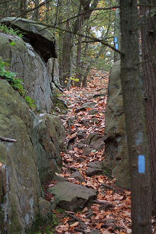
Taconic Trails or Taconic Trail may refer to any or all of three long distance recreational trails and associated networks of shorter trails within the Taconic Mountains of Massachusetts, New York, Connecticut, and Vermont.

<span class="mw-page-title-main">South Taconic Trail</span>

The South Taconic Trail is a 21.3 mi (34.3 km) hiking trail in the Taconic Mountains of southwest Massachusetts and adjacent New York. The trail extends from Shagroy Road in Millerton, New York, north along the ridgecrest of the southern Taconic Range and the border of New York and Massachusetts, and ends north of the Catamount Ski Area on Massachusetts Route 23 700 feet (210 m) east of the New York border in Egremont, Massachusetts. The Appalachian Trail, which traverses an adjacent ridgeline in the same mountain range, parallels the South Taconic Trail 3 mi (4.8 km) to the east. The trails are connected to one another via shorter trails.

Alander Mountain is 2,241-foot-tall (683 m) part of the south Taconic Mountains in southwest Massachusetts and adjacent New York. The summit is grassy and covered with scrub oak and shrubs; the sides of the mountain are heavily forested. Several trails traverse Alander Mountain, most notably the 15.7 mi (25.3 km) South Taconic Trail, which passes just beneath the summit.

The Taconic Skyline Trail is a 12.1 mi (19.5 km) multi-use trail in the Taconic Mountains of Berkshire County, Massachusetts. The trail extends from U.S. Route 20 in Hancock, Massachusetts, less than 1 mi (1.6 km) east of the New York border, north along the ridgecrest of the Taconic Range within Pittsfield State Forest and officially ending at Brodie Mountain Road on the Hancock/ Lanesborough town line.

Pine Mountain, 2,221 feet (677 m), is a prominent peak in the Taconic Mountains of western Massachusetts. The mountain is located in Pittsfield State Forest and is traversed by the Pine Mountain Trail, which connects to the 35 mi (56 km) Taconic Crest hiking trail and the 12.1 mi (19.5 km) multi-use Taconic Skyline Trail.

Berry Mountain, east peak 2,203 feet (671 m) and west peak 2,188 feet (667 m), is a prominent mountain in the Taconic Mountains of western Massachusetts. The mountain is located in Pittsfield State Forest. The west peak is traversed by the 35 mi (56 km) Taconic Crest hiking trail and the east peak is traversed by the 12.1 mi (19.5 km) multi-use Taconic Skyline Trail. The summits are mostly wooded with northern hardwood forest species, but also support a 65-acre (260,000 m2) field of wild azaleas. A microwave tower stands on the east peak. A park loop automobile road and a campground, maintained for summer use, are located just to the north of the summits. Berry Pond, 2,150 feet (660 m), presumed the highest natural pond in the state of Massachusetts, is located on the ridge between Berry Mountain and Berry Hill to the north.

Berry Hill, 2,200 feet (670 m), is a prominent mountain in the Taconic Mountains of western Massachusetts. The mountain is located in Pittsfield State Forest and is traversed by a short spur trail from a park automobile road. The Taconic Crest hiking trail and the multi-use Taconic Skyline Trail are located nearby. The mountain is known for its wild azalea fields. Its slopes are wooded with northern hardwood forest species. A park loop automobile road nearly encircles the summit, and a campground, maintained for summer use, is located just to the south of the summit. Berry Pond, 2,150 feet (660 m), presumed the highest natural pond in the state of Massachusetts, is located on the ridge between Berry Hill and Berry Mountain to the south.

Honwee Mountain, east summit 2,313 feet (705 m) and west summit 2,280 feet (690 m), is a prominent mountain in the Taconic Mountains of western Massachusetts. The mountain is located in Pittsfield State Forest. The east (highest) summit is traversed by the Honwee Circuit multi-use trail. The west summit is crossed by the 35 mi (56 km) Taconic Crest hiking trail and the 12.1 mi (19.5 km) multi-use Taconic Skyline Trail. The mountain is wooded with northern hardwood forest species.

Poppy Mountain, 2,311 feet (704 m), sometimes identified as Pease Ridge, its northwest descending crest, is a prominent peak in the Taconic Mountains of western Massachusetts. The mountain is located in Pittsfield State Forest and is traversed by the 35 mi (56 km) Taconic Crest hiking trail. The overgrown summit is wooded with northern hardwood forest species.

Smith Mountain, 2,170 feet (660 m), is a prominent peak in the Taconic Mountains of western Massachusetts, USA. The mountain is located in Pittsfield State Forest and is traversed by the 12.1 mi (19.5 km) multi-use Taconic Skyline Trail. The summit is known for its extensive stand of wild azalea and is wooded with northern hardwood tree species.

Doll Mountain, 1,930 feet (590 m), is a prominent peak in the Taconic Mountains of western Massachusetts. The mountain is located in Pittsfield State Forest. The summit is wooded and trailless, but the multi-use Doll Mountain Trail traverses its northern slopes. The mountain is wooded with northern hardwood tree species.

Holy Mount, 1,968 feet (600 m), is a prominent peak in the Taconic Mountains of western Massachusetts, formerly used as the location of religious ceremonies by a nearby Shaker community.

Potter Mountain is a prominent ridgeline located in the Taconic Mountains of western Massachusetts. It has several peaks; the most notable are the southern Jiminy Peak, 2,392 feet (729 m), which bears the name of the ski area located on its slopes, and Widow White's Peak, 2,430 feet (740 m), the ridge high point.

References

  1. 1 2 "Greenways and Trails" Massachusetts DCR. Retrieved February 22, 2008.
  2. 1 2 3 4 Commonwealth Connections: A greenway vision for Massachusetts (2002). Boston: Massachusetts DCR. PDF download retrieved February 23, 2008.