Related Research Articles
Mount Greylock is a 3,489 feet (1,063 m) mountain located in the northwest corner of Massachusetts and is the highest point in the state. Its summit is in the western part of the town of Adams in Berkshire County. Although technically it is geologically part of the Taconic Mountains, Mount Greylock is commonly associated with the abutting Berkshire Mountains to the east. The mountain is known for its expansive views encompassing five states and the only taiga-boreal forest in the state. A seasonal automobile road climbs to the summit, topped by a 93-foot-high (28 m) lighthouse-like Massachusetts Veterans War Memorial Tower. A network of hiking trails traverse the mountain, including the Appalachian Trail. Mount Greylock State Reservation was created in 1898 as Massachusetts' first public land for the purpose of forest preservation.

Schodack Island State Park is a 1,052-acre (4.26 km2) state park that spans portions of Rensselaer, Greene, and Columbia counties, New York. The park is located between the Hudson River and Schodack Creek, and was opened in 2002.

Chenango Valley State Park is a 1,137-acre (4.60 km2) state park located in Broome County, New York in the United States. The park is located adjacent to the Chenango River in western part of the Town of Fenton.
Mohawk State Forest, also known as Mohawk State Forest/Mohawk Mountain State Park, encompasses over 4,000 acres (1,600 ha) in the towns of Cornwall, Goshen, and Litchfield in the southern Berkshires of Litchfield County, Connecticut. As overseen by the Connecticut Department of Energy and Environmental Protection, the area is used for hiking, picnicking, and winter sports by the public, while being actively managed to produce timber and other forest products.
The Kettle Moraine State Forest is a state forest in southeastern Wisconsin. The chief feature of the reserve is the Kettle Moraine, a highly glaciated area. The area contains very hilly terrain and glacial landforms, such as kettles, kames and eskers. The 56,000-acre (23,000 ha) forest is divided into two large and three small units, which are spread across a hundred miles.

Mohawk Trail State Forest is a publicly owned forest with recreational features located in the towns of Charlemont, Hawley, and Savoy, Massachusetts. The state forest covers more than 7,700 acres (3,100 ha) of mountain ridges, gorges, and old-growth forests at elevations ranging from around 600 to 2,080 feet. It is managed by the Department of Conservation and Recreation.

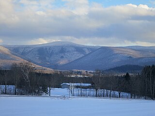
Savoy Mountain State Forest is a remote Massachusetts state forest located primarily in the towns of Savoy and Florida, with portions extending into neighboring Adams and North Adams. Situated along the Hoosac Mountain Range, it features four ponds, and seven hill and mountain summits, including Lewis Hill (2177 ft), Flat Rock Hill (2195 ft), Spruce Hill (2566 ft), and Borden Mountain (2505 ft). Also within the forest are at least two notable waterfalls, Parker Brook Falls and Tannery Falls, the latter of which is a 100-foot (30 m) drop. The forest is managed by the Department of Conservation and Recreation.
South River State Forest is located in Conway, Massachusetts. The forest is managed by the Department of Conservation and Recreation (DCR).

Cuivre River State Park is a public recreation area covering more than 6,400 acres (2,600 ha) northeast of the city of Troy in the Lincoln Hills region of northeastern Missouri, United States. The state park's rugged landscapes range from native grasslands and savannas to limestone bluffs over looking forested hills. The park offers an extensive system of hiking trails plus swimming and camping facilities and is managed by the Missouri Department of Natural Resources. It encompasses the Lincoln Hills Natural Area and two designated wild areas: Big Sugar Creek and Northwoods.

Pinckney State Recreation Area is a Michigan state recreation area in Dexter, Sylvan and Lyndon Townships, Washtenaw County and Putnam and Unadilla Townships, Livingston County in the U.S. state of Michigan. The park is 11,000 acres (4,500 ha) and sits at an elevation of 922 feet (281 m). The park is connected to the nearby Waterloo State Recreation Area by the 35-mile (56 km) Waterloo–Pinckney Trail. Pinckney State Recreation Area is open for year-round recreation including hiking, fishing, swimming, hunting and a variety of winter sports.
Erving State Forest is a publicly owned forest with recreational features located north of the Millers River in the towns of Erving, Warwick, and Orange, Massachusetts. The property is centered on Laurel Lake, a 51-acre (21 ha) body of water that has been a popular recreational destination since the 1930s. The forest's network of roads and hiking trails were largely created by the Civilian Conservation Corps. The forest is managed by the Department of Conservation and Recreation.

The Taconic Crest Trail is a 37 mi (60 km) hiking trail in the Taconic Mountains in the northeastern United States. The trail extends from U.S. Route 20 in Hancock, Massachusetts, less than 1 mi (1.6 km) east of the New York border, north along the ridgecrest of the Taconic Range, first within Massachusetts, then weaving along the border of New York and Massachusetts and New York and Vermont, and ending in Petersburgh, New York, on NY Route 346, near the Vermont border. Much of the route has been conserved as state forest, conservation easement, or forest preserve.
The Taconic Skyline Trail is a 12.1 mi (19.5 km) multi-use trail in the Taconic Mountains of Berkshire County, Massachusetts. The trail extends from U.S. Route 20 in Hancock, Massachusetts, less than 1 mi (1.6 km) east of the New York border, north along the ridgecrest of the Taconic Range within Pittsfield State Forest and officially ending at Brodie Mountain Road on the Hancock/ Lanesborough town line.

Tolland State Forest is a publicly owned forest with recreational features covering 4,415 acres (1,787 ha) in the towns of Otis, Tolland, Blandford and Sandisfield in the southern Berkshire Hills of Massachusetts. The state forest centers on the 1,065-acre (431 ha) Otis Reservoir, the largest body of water for recreational use in western Massachusetts. The forest is managed by the Department of Conservation and Recreation.

Willard Brook State Forest is a publicly owned forest with recreational features located in the towns of Ashby and Townsend, Massachusetts. The forest's fast-running brook and tree stands of a classic New England nature give it a character more in line with that of the forests found farther west in the state. It is managed by the Department of Conservation and Recreation.
Kenneth Dubuque Memorial State Forest is a Massachusetts state forest in the northern Berkshire Hills in the towns of Hawley, Plainfield, and Savoy. The forest is managed by the Department of Conservation and Recreation (DCR). In 1985, the forest was named in memory of Kenneth M. Dubuque, a former employee of the Department of Environmental Management.
Lowell-Dracut-Tyngsboro State Forest is a publicly owned forest with recreational features measuring 1,109 acres (449 ha) that overlap the City of Lowell, and the towns of Dracut and Tyngsborough, Massachusetts. The forest, which includes some 180 acres (73 ha) of ponds, swamps and wetlands, is maintained by the Massachusetts Department of Conservation and Recreation.
The Naugatuck Trail is a 6.8-mile (10.9 km) Blue-Blazed hiking trail "system" in the eastern central-lower Naugatuck River Valley in New Haven County, Connecticut, USA and is today almost entirely contained in the Naugatuck State Forest. The mainline trail is primarily east to west with three short side or spur trails.

Deam Lake State Recreation Area is an Indiana State Recreation Area in Clark County, Indiana in the United States. The park is 1,300 acres (530 ha) and sits at an elevation of 535 feet (163 m). Deam Lake State Recreation area is open for year-round recreation, however the campground closes each year from the Sunday before Thanksgiving to March 1 of the following year. Much of the recreation is centered on Deam Lake. It is named for Charles C. Deam, the first state forester of Indiana.

Powhatan State Park is a state park located along the James River in Virginia. It is in Powhatan County. The park is 1,565 acres (6 km2) total with a 2-mile (3.2 km) of riverfront.
References
- ↑ "Mahican-Mohawk Trail". MassParks. Executive Office of Energy and Environmental Affairs. Retrieved September 2, 2015.
- ↑ "The Mahican-Mohawk Trail". FranklinSites.com Hiking Guide. Retrieved September 2, 2015.