Related Research Articles

McKean County is a rural county in the Commonwealth of Pennsylvania. As of the 2020 census, the population was 40,432. Its county seat is Smethport. The county was created in 1804 and organized in 1826. It was named in honor of former Pennsylvania Governor and Declaration of Independence signer Thomas McKean.
Heilwood is a census-designated place (CDP) in Indiana County, Pennsylvania, United States. The population was 711 at the time of the 2010 census.

Eldred Township is a township in Jefferson County, Pennsylvania, United States. The population was 1,273 at the 2020 census. It was named for Nathaniel B. Eldred, President Judge of the judicial district of which Jefferson County was a part.

Heath Township is a township in Jefferson County, Pennsylvania, United States. The population was 117 at the 2020 census, down from the figure of 124 tabulated in 2010. It was named for early Jefferson County settler Elijah Heath. Heath Township is the second-smallest municipality in Jefferson County.

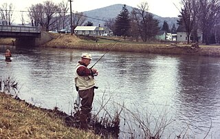
Eldred is a borough in McKean County, Pennsylvania, United States. The population was 760 at the 2020 census.

Eldred Township is a township in McKean County, Pennsylvania, United States. The population was 1,382 at the 2020 census.

Eldred Township is a township in Schuylkill County, Pennsylvania, United States. Settled in 1805 and incorporated in 1849 from part of Upper Mahantongo Township, it is named for Judge Nathaniel Eldred. The population was 709 at the 2020 census.

Eldred Township is a township in Warren County, Pennsylvania, United States. The population was 587 at the 2020 census, down from 650 at the 2010 census.

Pennsylvania's fifth congressional district encompasses all of Delaware County, an exclave of Chester County, a small portion of southern Montgomery County and a section of southern Philadelphia. Democrat Mary Gay Scanlon represents the district.
Potato Creek is a tributary of the Allegheny River that is located in McKean County, Pennsylvania in the United States.
North Fork Creek is a tributary of Redbank Creek in northwest Pennsylvania in the United States. It is formed by the confluence of Muddy Run and Williams Run in Polk Township, Jefferson County.

Bluffdale Township is one of thirteen townships in Greene County, Illinois, USA. As of the 2010 census, its population was 556 and it contained 273 housing units.
The Eldred World War II Museum is located in Eldred, Pennsylvania, 80 miles south of Buffalo, New York and 175 miles north east of Pittsburgh, Pennsylvania. Established in May 1996, the museum has continually expanded from one room to three stories. The Eldred World War II Museum is a non-profit organization that offers visitors an array of exhibits and information about World War II.

Mangum Township is one of six townships in Durham County, North Carolina, United States. The township had a population of 5,821 according to the 2000 census.

Farmers Valley is an unincorporated community in Keating Township, McKean County, Pennsylvania, United States, situated between Coryville and Smethport.

The Otto-Eldred School District is a diminutive, rural, public school district located in McKean County, Pennsylvania. The school district is named after three of the four municipalities it serves: Eldred, Eldred Township, and Otto Township. A portion of Ceres Township is also within the district's taxation and attendance boundaries. Otto-Eldred School District encompasses approximately 86 square miles (220 km2). According to 2000 federal census data, it serves a resident population of 4,493, while in 2010 the population had declined to 4,172 people. In 2009, Otto-Eldred School District residents' per capita income was $15,580, while the median family income was $38,393. In a hearing before the Pennsylvania House Appropriations Committee in 2009, then Superintendent Falk, reported that Otto-Eldred School District was the poorest in the Commonwealth.
Hostetter is a census-designated place located in Unity Township, Westmoreland County in the state of Pennsylvania, United States. It is located near Pennsylvania Route 981. As of the 2010 census the population was 740 residents.
Yulan is a community and census tract in Sullivan County, New York, United States.
Howe is an unincorporated community in Jefferson County, in the U.S. state of Pennsylvania.
The Pennsylvania State Game Lands Number 14 are Pennsylvania State Game Lands in Cameron, and Elk Counties in Pennsylvania in the United States providing hunting, bird watching, and other activities.
References
- ↑ "Coryville". Geographic Names Information System. 2010. Retrieved March 18, 2010.
Municipalities and communities of McKean County, Pennsylvania, United States | ||
|---|---|---|
| City | 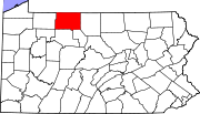 | |
| Boroughs | ||
| Townships | ||
| CDPs | ||
| Unincorporated communities | ||
41°52′57″N78°23′54″W / 41.88250°N 78.39833°W
| | This McKean County, Pennsylvania state location article is a stub. You can help Wikipedia by expanding it. |