McKean County is a rural county in the Commonwealth of Pennsylvania. As of the 2020 census, the population was 40,432. Its county seat is Smethport. The county was created in 1804 and organized in 1826. It was named in honor of former Pennsylvania Governor and Declaration of Independence signer Thomas McKean.

New London Township is a township that is located in Chester County, Pennsylvania, United States. It was the birthplace of U.S. Founding Father Thomas McKean.

McKean is a borough in Erie County, Pennsylvania. The population was 475 at the time of the 2020 census. It is part of the Erie–Meadville combined statistical area. McKean was known as "Middleboro" until it officially changed its name in 1970.
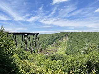
Kinzua Bridge State Park is a 339-acre (137 ha) Pennsylvania state park near Mount Jewett, in Hamlin and Keating Townships, McKean County, Pennsylvania in the United States. The park lies between U.S. Route 6 and Pennsylvania Route 59, along State Route 3011 just east of the Allegheny National Forest.

Samuel McKean was an American merchant and politician from Burlington, Pennsylvania, who served as a Democratic member of the U.S. Senate for Pennsylvania from 1833 to 1839 and of the U.S. House of Representatives for Pennsylvania's 9th congressional district from 1823 to 1829. He served in the Pennsylvania House of Representatives from 1815 to 1819 and the Pennsylvania State Senate for the 11th district from 1829 to 1830.
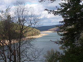
Elk State Park is a 3,192-acre (1,292 ha) Pennsylvania state park in Jones Township, Elk County and Sergeant Township, McKean County, Pennsylvania, in the United States. East Branch Clarion River Lake is a man-made lake covering 1,160 acres (470 ha) within the park. The lake and streams in the park are stocked with cold and warm water fish. There are 3,151 acres (1,275 ha) of woods open to hunting.
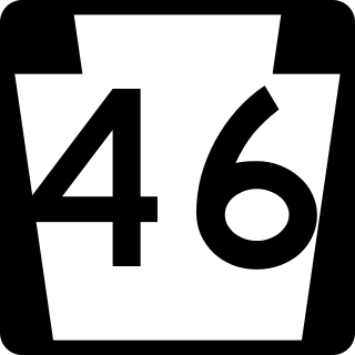
Pennsylvania Route 46 is a 43-mile-long (69 km) state highway that is located in northern Pennsylvania in the United States.

Pennsylvania Route 155 is a 32.2-mile-long (51.8 km) state highway located in Cameron, Potter, and McKean counties in Pennsylvania. The southern terminus is at PA 120 in Emporium. The northern terminus is at PA 446 in Eldred Township.

Pennsylvania Route 246 is an 8-mile-long (13 km) state highway located in McKean County in Pennsylvania. The western terminus is at PA 46 in Corwins Corners. The eastern terminus is at PA 346 in Prentisvale.

Pennsylvania Route 346 (PA 346) is a 34.177-mile (55.003 km) state highway located in Warren and McKean counties in Pennsylvania, United States The western terminus is at the New York state line in the Allegheny National Forest, where it becomes New York State Route 280 (NY 280). The eastern terminus is at an intersection with PA 446 in Eldred. The route is mostly a two-lane road that passes through rural areas in the northern part of McKean County. PA 346 passes through the city of Bradford, where it has a concurrency with the U.S. Route 219 (US 219) freeway.

Pennsylvania Route 546 is a 3.586-mile-long (5.771 km) state highway in the northernmost regions of McKean County, Pennsylvania. The route, known locally as Oil Valley Road, begins at an intersection with PA 346 in the community of Duke Center. The highway heads northward, through mountainous regions before crossing the state line and into New York.

Pennsylvania Route 646 is a 19.15 miles (30.82 km) long state highway located in McKean County in Pennsylvania. The southern terminus is at PA 59 in Keating Township. The northern terminus is the New York state line in Foster Township. The route continues as New York State Route 16 in Cattaugarus County.

Pennsylvania Route 770 is a 12-mile-long (19 km), east–west state highway that is located in McKean County in Pennsylvania.

This is a list of the National Register of Historic Places listings in McKean County, Pennsylvania.
Sterrettania is a populated place located in Erie County, Pennsylvania, United States. It is in Fairview and McKean townships, in the valley of Elk Creek, a short tributary of Lake Erie.
Sergeant is an unincorporated community in Wetmore Township in McKean County, Pennsylvania, United States. Sergeant is located along Pennsylvania Route 321, southeast of Kane.
East Kane is an unincorporated community in Wetmore Township in McKean County, Pennsylvania, United States. East Kane is located along Pennsylvania Route 321 southeast of Kane.
Dunkle Corners is an unincorporated community in Hamilton Township in McKean County, Pennsylvania, United States. Dunkle Corners is located along Pennsylvania Route 321, on the shore of the Allegheny Reservoir to the north of Kane.
Lantz Corners is an unincorporated community in Hamlin Township in McKean County, Pennsylvania, United States. Lantz Corners is located at the intersection of U.S. Route 6 and U.S. Route 219 to the southwest of Mount Jewett.
The Pennsylvania State Game Lands Number 30 are Pennsylvania State Game Lands in McKean County in Pennsylvania in the United States providing hunting, bird watching, and other activities.