Lewis Run, Pennsylvania

Last updated

Lewis Run, Pennsylvania
Lewis Run from SR 4001.jpg
The borough of Lewis Run from the hills and State Route 4001 (Lafayette Avenue).
McKean County Pennsylvania Incorporated and Unincorporated areas Lewis Run Highlighted.svg
Location of Lewis Run in McKean County, Pennsylvania.
USA Pennsylvania location map.svg
Red pog.svg
Lewis Run
Usa edcp location map.svg
Red pog.svg
Lewis Run
Coordinates: 41°52′12″N78°39′44″W / 41.87000°N 78.66222°W / 41.87000; -78.66222
Country United States
State Pennsylvania
County McKean
Incorporated1911
Area
[1]
  Total1.84 sq mi (4.76 km2)
  Land1.83 sq mi (4.74 km2)
  Water0.01 sq mi (0.03 km2)
Population
 (2020) [2]
  Total583
  Density318.75/sq mi (123.08/km2)
Time zone UTC-5 (Eastern (EST))
  Summer (DST) UTC-4 (EDT)
Zip code
16738
Area code 814
FIPS code 42-42984

Lewis Run is a borough in McKean County, Pennsylvania, United States. The population was 578 at the 2020 census. [3]

Contents

Demographics

Historical population
CensusPop.Note
1920 665
1930 83725.9%
1940 8440.8%
1950 694−17.8%
1960 7142.9%
1970 7565.9%
1980 677−10.4%
1990 578−14.6%
2000 577−0.2%
2010 6176.9%
2020 578−6.3%
2021 (est.)570 [3] −1.4%
Sources: [4] [5] [6] [2]

As of the census [5] of 2000, there were 577 people, 259 households, and 178 families residing in the borough. The population density was 297.7 inhabitants per square mile (114.9/km2). There were 287 housing units at an average density of 148.1 per square mile (57.2/km2). The racial makeup of the borough was 98.61% White, 0.17% African American, 0.52% Native American, 0.17% Asian, 0.17% from other races, and 0.35% from two or more races. Hispanic or Latino of any race were 0.17% of the population.

There were 259 households, out of which 25.9% had children under the age of 18 living with them, 57.1% were married couples living together, 6.9% had a female householder with no husband present, and 30.9% were non-families. 28.2% of all households were made up of individuals, and 14.3% had someone living alone who was 65 years of age or older. The average household size was 2.23 and the average family size was 2.70.

In the borough the population was spread out, with 19.4% under the age of 18, 6.6% from 18 to 24, 27.0% from 25 to 44, 23.2% from 45 to 64, and 23.7% who were 65 years of age or older. The median age was 43 years. For every 100 females there were 96.9 males. For every 100 females age 18 and over, there were 92.1 males.

The median income for a household in the borough was $35,221, and the median income for a family was $41,719. Males had a median income of $31,042 versus $23,750 for females. The per capita income for the borough was $21,670. About 3.8% of families and 6.5% of the population were below the poverty line, including 8.1% of those under age 18 and 7.5% of those age 65 or over.

Geography

Lewis Run is located at 41°52′12″N78°39′44″W / 41.87000°N 78.66222°W / 41.87000; -78.66222 (41.870101, -78.662201). [7]

According to the United States Census Bureau, the borough has a total area of 1.9 square miles (4.9 km2), all land.

Climate

According to the Köppen Climate Classification system, Lewis Run has a humid continental climate, abbreviated "Dfb" on climate maps. [8]

Climate data for Lewis Run, Pennsylvania
MonthJanFebMarAprMayJunJulAugSepOctNovDecYear
Average high °C (°F)−1
(31)
1
(33)
6
(43)
13
(56)
20
(68)
24
(76)
26
(79)
25
(77)
22
(71)
16
(60)
8
(46)
2
(35)
13
(56)
Average low °C (°F)−11
(13)
−11
(13)
−6
(21)
−1
(31)
5
(41)
10
(50)
12
(54)
12
(53)
8
(46)
2
(36)
−2
(28)
−8
(18)
1
(34)
Average precipitation mm (inches)79
(3.1)
66
(2.6)
86
(3.4)
94
(3.7)
100
(4.1)
120
(4.9)
120
(4.7)
100
(4)
110
(4.2)
94
(3.7)
99
(3.9)
89
(3.5)
1,160
(45.8)
Source: Weatherbase [9]

Related Research Articles

<span class="mw-page-title-main">Bon Air, Alabama</span> Town in Alabama, United States

Bon Air is a town in Talladega County, Alabama, United States. It incorporated in 1932. At the 2010 census the population was 116, up from 96 in 2000.

<span class="mw-page-title-main">Chatom, Alabama</span> City in and county seat of Washington County, Alabama

Chatom is a town in Washington County, Alabama, United States. It incorporated in 1949. Chatom is the county seat of Washington County, holding the distinction since 1907. The town's population was 1,288 At the 2010 census, up from 1,193 in 2000.

<span class="mw-page-title-main">Horton, Kansas</span> City in Brown County, Kansas

Horton is a city in Brown County, Kansas, United States. As of the 2020 census, the population of the city was 1,523.

<span class="mw-page-title-main">Clarence, Louisiana</span> Village in Louisiana, United States

Clarence is a village in Natchitoches Parish, Louisiana, United States. The population was 499 at the 2010 census. It is located some seven miles east of the parish seat of Natchitoches and is part of the Natchitoches Micropolitan Statistical Area.

<span class="mw-page-title-main">Powhatan, Louisiana</span> Village in Louisiana, United States

Powhatan is a village in Natchitoches Parish, Louisiana, United States. The population was 141 at the 2000 census. It is part of the Natchitoches Micropolitan Statistical Area.

<span class="mw-page-title-main">Fruitland, Maryland</span> City in Maryland, United States

Fruitland is a city in Wicomico County, Maryland, United States. The population was 4,866 at the 2010 census. It is included in the Salisbury, Maryland-Delaware Metropolitan Statistical Area.

<span class="mw-page-title-main">Winton, Minnesota</span> City in Minnesota, United States

Winton is a city in Saint Louis County, Minnesota, United States. The population was 172 at the 2010 census. The city is home to a small hydroelectric dam on the edge of Garden Lake, one of 11 stations owned by Minnesota Power.

<span class="mw-page-title-main">Lolo, Montana</span> CDP in Montana, United States

Lolo is a census-designated place (CDP) in Missoula County, Montana, United States. It is part of the Missoula Metropolitan Statistical Area. The population was 4,399 at the 2020 census, an increase from its population of 3,892 in 2010. It is home to Travelers' Rest State Park, a site where Lewis and Clark camped in 1805 and again in 1806.

<span class="mw-page-title-main">Everett, Pennsylvania</span> Borough in Pennsylvania, United States

Everett is a borough in Bedford County, Pennsylvania, United States. The population was 1,775 at the 2020 census.

<span class="mw-page-title-main">Bowmanstown, Pennsylvania</span> Borough in Pennsylvania, United States

Bowmanstown is a borough in Carbon County, Pennsylvania. It is part of Northeastern Pennsylvania. The population was 937 at the 2010 census.

<span class="mw-page-title-main">Nesquehoning, Pennsylvania</span> Borough in Pennsylvania, United States

Nesquehoning is a borough in Carbon County, Pennsylvania, United States. It is part of Northeastern Pennsylvania. The population was 3,336 at the 2020 census.

<span class="mw-page-title-main">Troutville, Pennsylvania</span> Borough in Pennsylvania, United States

Troutville is a borough in Clearfield County, Pennsylvania, United States. The population was 230 at the 2020 census.

<span class="mw-page-title-main">Freeland, Pennsylvania</span> Borough in Pennsylvania, United States

Freeland is a borough in Luzerne County, Pennsylvania, United States. It was originally called Birbeckville, South Heberton, and Freehold. Freeland is 18 miles (29 km) south of Wilkes-Barre and 10 miles (16 km) northeast of Hazleton. It was incorporated as a borough on September 11, 1876. Coal mining was the chief industry in the community through the mid-20th century. As of the 2020 census, the population was 3,833.

<span class="mw-page-title-main">Nescopeck, Pennsylvania</span> Borough in Pennsylvania, United States

Nescopeck is a borough in Luzerne County, Pennsylvania. The population was 1,480 as of the 2020 census.

<span class="mw-page-title-main">New Lebanon, Pennsylvania</span> Borough in Pennsylvania, United States

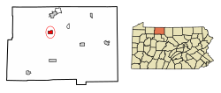
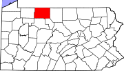
New Lebanon is a borough in northeastern Mercer County, Pennsylvania, United States. The population was 186 at the 2020 census. It is part of the Youngstown–Warren metropolitan area.

<span class="mw-page-title-main">Glendon, Pennsylvania</span> Place in Pennsylvania, United States

Glendon is a borough in Northampton County, Pennsylvania. The population of Glendon was 373 at the 2020 census. Glendon is part of the Lehigh Valley metropolitan area, which had a population of 861,899 and was thus the 68th-most populous metropolitan area in the U.S. as of the 2020 census.

<span class="mw-page-title-main">Loudon, Tennessee</span> City in Tennessee, United States

Loudon is a city in and the county seat of Loudon County, Tennessee, United States. Its population was 6,001 at the 2020 census. It is included in the Knoxville, Tennessee Metropolitan Statistical Area. The city is located in East Tennessee, southwest of Knoxville, on the Tennessee River. Fort Loudoun, the colonial era fort for which the city was named, is located several miles to the south in Monroe County.

<span class="mw-page-title-main">Jane Lew, West Virginia</span> Town in West Virginia, United States

Jane Lew is a town in Lewis County, West Virginia, United States. The population was 409 at the time of the 2020 census.

<span class="mw-page-title-main">St. Germain, Wisconsin</span> Town in Wisconsin, United States

St. Germain is a town in Vilas County, Wisconsin, United States. The population was 1,932 at the 2000 census. The unincorporated community of St. Germain is located in the town.

<span class="mw-page-title-main">Yorkville, Ohio</span> Village in Ohio, United States

Yorkville is a village in Belmont and Jefferson counties in the U.S. state of Ohio. The population was 968 at the 2020 census. Yorkville lies within two Metropolitan Statistical Areas; the Belmont County portion is part of the Wheeling metropolitan area, while the Jefferson County portion is part of the Weirton–Steubenville metropolitan area.

References

  1. "ArcGIS REST Services Directory". United States Census Bureau. Retrieved October 12, 2022.
  2. 1 2 "Census Population API". United States Census Bureau. Retrieved October 12, 2022.
  3. 1 2 Bureau, US Census. "City and Town Population Totals: 2020-2021". Census.gov. US Census Bureau. Retrieved July 17, 2022.
  4. "Census of Population and Housing". U.S. Census Bureau. Retrieved December 11, 2013.
  5. 1 2 "U.S. Census website". United States Census Bureau . Retrieved January 31, 2008.
  6. "Incorporated Places and Minor Civil Divisions Datasets: Subcounty Resident Population Estimates: April 1, 2010 to July 1, 2012". Population Estimates. U.S. Census Bureau. Archived from the original on June 11, 2013. Retrieved December 11, 2013.
  7. "US Gazetteer files: 2010, 2000, and 1990". United States Census Bureau. February 12, 2011. Retrieved April 23, 2011.
  8. Climate Summary for Lewis Run, Pennsylvania
  9. "Weatherbase.com". Weatherbase. 2013. Retrieved on October 19, 2013.