Ward County is a county in the U.S. state of North Dakota. As of the 2020 census, the population was 69,919, making it the fourth-most populous county in North Dakota. Its county seat is Minot. Ward County is part of the Minot, ND Micropolitan Statistical Area.

Mountrail County is a county in the northwestern part of North Dakota, United States. As of the 2020 census, the population was 9,809. Its county seat is Stanley. The county was originally created in 1873, then removed in 1892, annexed by Ward County. It was re-created and organized in 1909.

Burke County is a county on the north edge of the U.S. state of North Dakota, adjacent to the south line of Canada. As of the 2020 census, the population was 2,201. The county seat is Bowbells. The county is named after John Burke, the tenth Governor of North Dakota.

Stanley is a city in Mountrail County, North Dakota, United States. It is the county seat of Mountrail County. The population was 2,579 at the 2020 census, making it the 20th largest city in North Dakota. Stanley was founded in 1902. The town's economy is heavily connected to the nearby oil-rich Bakken Formation.

This is a list of properties and historic districts in the U.S. state of South Dakota that are listed on the National Register of Historic Places. The state's more than 1,300 listings are distributed across all of its 66 counties.

There are 461 properties and historic districts listed on the National Register of Historic Places in North Dakota. There are listings in 52 of North Dakota's 53 counties.

Birch Coulee Battlefield in Renville County, Minnesota, United States, was the site of the Battle of Birch Coulee, the costliest military engagement for U.S. forces during the Dakota War of 1862. It is now a historic site with self-guided trails and markers interpreting the battle from both sides. Birch Coulee was nominated to the National Register of Historic Places for having state-level significance in military history, and was listed in 1973.

This is a list of the National Register of Historic Places listings in Jerauld County, South Dakota.

This is a list of the National Register of Historic Places listings in Potter County, South Dakota.

Buechner & Orth was a St. Paul, Minnesota-based architectural firm that designed buildings in Minnesota and surrounding states, including 13 courthouses in North Dakota. It was the subject of a 1979 historic resources study.

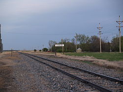
Our Savior's Scandinavian Lutheran Church, also known as Our Savior's Lutheran Church or Our Savior's Evangelical Lutheran Church is located in Ward County, North Dakota. It is situated one mile north of State Route #50 and one quarter mile west of Ward County Highway #1 near Coulee, Mountrail County, North Dakota. The church and its cemetery were listed on the National Register of Historic Places in 2005.
Coulee is a type of valley or drainage zone.
The Mountrail County Courthouse in Stanley, North Dakota was built in 1914 and served Mountrail County as its courthouse continuously since then. It was designed by architects Buechner & Orth in what can be termed Academic Revival architecture and/or Late 19th and 20th Century Revivals architecture. It was listed on the National Register of Historic Places in 1978; a 2.1-acre (0.85 ha) area was included in the listing.

Crow Flies High State Recreation Area is a scenic overlook located two miles west of New Town in Mountrail County, North Dakota. The site provides scenic views of Lake Sakakawea. Signs describe the location's role in local history, including its significance in the explorations of Lewis and Clark. The footprint of the drowned town of Sanish, now lost below the reservoir's waves, can be seen at times of low water.
The Parshall Oil Field is an oil field producing from the Bakken Formation and Three Forks Formation near the town of Parshall, in Mountrail County, North Dakota. The field is in the Williston Basin. The field was discovered in 2006 by Michael Johnson and sold the play to EOG Resources, which drilled, and now operates, most of the wells. It was the discovery of the Parshall Field that was largely responsible for the North Dakota oil boom. Parshall's break-even price is at US$38/barrel, which is the lowest on the Bakken Formation; overall, Bakken's break-even point is of US$62/barrel.
Manitou is an unincorporated community in Mountrail County, in the U.S. state of North Dakota.
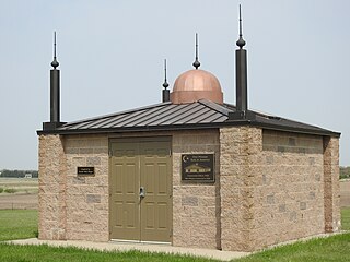
The Assyrian Muslim Cemetery is a Muslim cemetery in Mountrail County, North Dakota, which was listed on the National Register of Historic Places in 2018. It is the oldest Muslim cemetery in the United States, and was the only Muslim cemetery in North Dakota for 90 years. It is located 1/4 mile south of US 2 on 87th Ave. NW, near Ross.
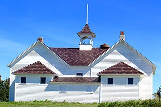
The Wabek Consolidated School, at 3825 64th Ave. NW in Mountrail County, North Dakota, near Plaza, North Dakota, was listed on the National Register of Historic Places in 2019.

Wabek is an unincorporated community in the southeast corner of Mountrail County, North Dakota, United States. Wabek was founded shortly after the Soo Line laid their railroad tracks in the coulee directly north of the village. Since its inception, Wabek has served as the heart and hub of Plaza Township, as well as two Mountrail County townships to the south: Mountrail Township and Banner Township.