Parshall, North Dakota

Last updated

Parshall, North Dakota
BrosteMuseum.jpg
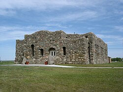
Paul Broste Rock Museum in Parshall
ND Mountrail County Parshall.svg
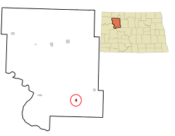
Location of Parshall, North Dakota
Coordinates: 47°57′34″N102°08′02″W / 47.95944°N 102.13389°W / 47.95944; -102.13389
CountryUnited States
State North Dakota
County Mountrail
Founded1914
Government
   Mayor Kyle Christianson
Area
[1]
  Total3.55 sq mi (9.18 km2)
  Land3.55 sq mi (9.18 km2)
  Water0.00 sq mi (0.00 km2)
Elevation
[2]
1,978 ft (603 m)
Population
 (2020) [3]
  Total949
  Estimate 
(2022) [4]
895
  Density267.63/sq mi (103.34/km2)
Time zone UTC-6 (Central (CST))
  Summer (DST) UTC-5 (CDT)
ZIP code
58770
Area code 701
FIPS code 38-60940
GNIS feature ID1036214 [2]
Website parshallnd.com

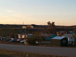
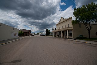
Parshall (Hidatsa: dibiarugareesh) [5] is a city lying within the jurisdictional boundaries of the Mandan, Hidatsa, and Arikara Nation. It is located on the Fort Berthold Indian Reservation in Mountrail County, North Dakota, United States. The population was 949 at the 2020 census. [3] Parshall was founded in 1914 by George Parshall, and is the home of the Paul Broste Rock Museum.

Contents

On February 15, 1936, Parshall recorded a temperature of −60 °F or −51.1 °C, setting a state record low temperature, which still stands today. [6] Relatively nearby Steele, ND recorded a state record high of 121 °F or 49.4 °C less than five months later.

During the calendar year 1934, in the midst of the severe multi-year drought that affected most of North America during much of the 1930s, Parshall recorded a total of 4.02 inches or 102.1 millimetres of precipitation, less than 12 percent of the long-term normal and much less than normally falls in most of the Sonoran Desert. [7]

Randy Hedberg, a former NFL quarterback, was born and raised in Parshall. Another notable native of Parshall is Raymond Cross, a stand out high school basketball player and now a law professor in Montana. [8]

Geography

According to the United States Census Bureau, the city has a total area of 0.55 square miles (1.42 km2), all land. [9]

Demographics

Historical population
CensusPop.Note
1920 376
1930 47025.0%
1940 57021.3%
1950 93564.0%
1960 1,21630.1%
1970 1,2462.5%
1980 1,059−15.0%
1990 943−11.0%
2000 9814.0%
2010 903−8.0%
2020 9495.1%
2022 (est.)895 [4] −5.7%
U.S. Decennial Census [10]
2020 Census [3]

2010 census

As of the census of 2010, there were 903 people, 313 households, and 220 families residing in the city. The population density was 1,641.8 inhabitants per square mile (633.9/km2). There were 364 housing units at an average density of 661.8 per square mile (255.5/km2). The racial makeup of the city was 30.6% White, 0.3% African American, 62.7% Native American, 0.7% from other races, and 5.8% from two or more races. Hispanic or Latino of any race were 6.5% of the population.

There were 313 households, of which 44.1% had children under the age of 18 living with them, 38.7% were married couples living together, 22.0% had a female householder with no husband present, 9.6% had a male householder with no wife present, and 29.7% were non-families. 24.3% of all households were made up of individuals, and 7.3% had someone living alone who was 65 years of age or older. The average household size was 2.86 and the average family size was 3.41.

The median age in the city was 31.6 years. 32.2% of residents were under the age of 18; 10.2% were between the ages of 18 and 24; 23.2% were from 25 to 44; 25.6% were from 45 to 64; and 9% were 65 years of age or older. The gender makeup of the city was 49.8% male and 50.2% female.

2000 census

As of the census of 2000, there were 981 people, 339 households, and 240 families residing in the city. The population density was 1,803.4 inhabitants per square mile (696.3/km2). There were 392 housing units at an average density of 720.6 per square mile (278.2/km2). The racial makeup of the city was 41.79% White, 0.31% African American, 54.54% Native American, 1.22% from other races, and 2.14% from two or more races. Hispanic or Latino of any race were 3.26% of the population.

There were 339 households, out of which 39.5% had children under the age of 18 living with them, 39.2% were married couples living together, 25.4% had a female householder with no husband present, and 29.2% were non-families. 26.3% of all households were made up of individuals, and 15.6% had someone living alone who was 65 years of age or older. The average household size was 2.75 and the average family size was 3.23.

In the city, the population was spread out, with 33.1% under the age of 18, 8.3% from 18 to 24, 23.4% from 25 to 44, 16.8% from 45 to 64, and 18.3% who were 65 years of age or older. The median age was 33 years. For every 100 females, there were 91.2 males. For every 100 females age 18 and over, there were 84.8 males.

The median income for a household in the city was $24,500, and the median income for a family was $27,222. Males had a median income of $23,558 versus $21,750 for females. The per capita income for the city was $11,459. About 21.6% of families and 27.7% of the population were below the poverty line, including 35.6% of those under age 18 and 20.3% of those age 65 or over.

Education

Parshall High School in 2008 Parshall High School.jpg
Parshall High School in 2008

There are two schools in Parshall operated by Parshall Public Schools, the public elementary school and the public high school. [11]

Demography

Along with White Shield, North Dakota, Parshall is home to speakers of the Arikara language. [12]

Oil development

Parshall is, perhaps, best known nationally for its namesake Parshall Oil Field, which surrounds the town. The 2006 discovery of the Parshall Field started the North Dakota oil boom. [13]

Aspects of the oil boom near Parshall were presented in the series Boomtown on Discovery Communications cable channel Planet Green.

Climate

This climatic region is typified by large seasonal temperature differences, with warm to hot (and often humid) summers and cold (sometimes severely cold) winters. According to the Köppen climate classification system, Parshall has a humid continental climate, abbreviated Dfb on climate maps. [14]

Climate data for Parshall, North Dakota, 1931–1979 normals and extremes
MonthJanFebMarAprMayJunJulAugSepOctNovDecYear
Record high °F (°C)55
(13)
64
(18)
80
(27)
92
(33)
101
(38)
104
(40)
112
(44)
107
(42)
103
(39)
96
(36)
75
(24)
63
(17)
112
(44)
Mean daily maximum °F (°C)17.2
(−8.2)
23.0
(−5.0)
35.3
(1.8)
53.2
(11.8)
67.4
(19.7)
75.4
(24.1)
83.9
(28.8)
82.9
(28.3)
71.1
(21.7)
58.9
(14.9)
37.5
(3.1)
24.7
(−4.1)
52.5
(11.4)
Daily mean °F (°C)6.0
(−14.4)
11.8
(−11.2)
24.2
(−4.3)
40.5
(4.7)
53.4
(11.9)
62.2
(16.8)
68.8
(20.4)
66.9
(19.4)
55.8
(13.2)
44.8
(7.1)
26.6
(−3.0)
13.9
(−10.1)
39.6
(4.2)
Mean daily minimum °F (°C)−5.2
(−20.7)
0.4
(−17.6)
13.2
(−10.4)
27.8
(−2.3)
39.4
(4.1)
49.0
(9.4)
53.8
(12.1)
50.9
(10.5)
40.6
(4.8)
30.7
(−0.7)
15.8
(−9.0)
3.2
(−16.0)
26.6
(−3.0)
Record low °F (°C)−45
(−43)
−60
(−51)
−35
(−37)
−16
(−27)
13
(−11)
26
(−3)
31
(−1)
25
(−4)
4
(−16)
−6
(−21)
−29
(−34)
−37
(−38)
−60
(−51)
Average precipitation inches (mm)0.31
(7.9)
0.33
(8.4)
0.41
(10)
1.24
(31)
2.16
(55)
3.51
(89)
2.26
(57)
1.83
(46)
1.66
(42)
0.70
(18)
0.40
(10)
0.33
(8.4)
15.14
(382.7)
Average snowfall inches (cm)3.9
(9.9)
3.6
(9.1)
3.4
(8.6)
2.6
(6.6)
0.6
(1.5)
0.0
(0.0)
0.0
(0.0)
0.0
(0.0)
0.3
(0.76)
1.4
(3.6)
3.5
(8.9)
3.8
(9.7)
23.1
(58.66)
Average precipitation days (≥ 0.01 in)4.74.04.86.28.610.97.97.36.44.44.34.173.6
Average snowy days (≥ 0.1 in)4.03.22.81.30.20.00.00.00.20.92.63.518.7
Source: XMACIS2 (precip/precip days, snow/snow days 19161979) [15]

Related Research Articles

<span class="mw-page-title-main">Rogers, North Dakota</span> City in North Dakota, United States

Rogers is a city in Barnes County, North Dakota, United States. The population was 49 at the 2020 census. Rogers was founded in 1897.

<span class="mw-page-title-main">Maddock, North Dakota</span> City in North Dakota, United States

Maddock is a city in Benson County, North Dakota, United States. The population was 402 at the 2020 census. Maddock was founded in 1901.

<span class="mw-page-title-main">Killdeer, North Dakota</span> City in North Dakota, United States

Killdeer is a city in Dunn County, North Dakota, United States. The population was 939 at the 2020 census.

<span class="mw-page-title-main">Sentinel Butte, North Dakota</span> City in North Dakota, United States

Sentinel Butte is a city in Golden Valley County, North Dakota, United States. The population was 61 at the 2020 census.

<span class="mw-page-title-main">Carson, North Dakota</span> City in North Dakota, United States

Carson is a city in and the county seat of Grant County, North Dakota, United States. The population was 254 at the 2020 census.

<span class="mw-page-title-main">Wishek, North Dakota</span> City in North Dakota, United States

Wishek is a city in McIntosh County, North Dakota, United States. The population was 864 at the 2020 census.

<span class="mw-page-title-main">Mandaree, North Dakota</span> Census-designated place & Unincorporated community in North Dakota, United States

Mandaree is a census-designated place (CDP) in McKenzie County, North Dakota, United States. The population was 596 at the 2010 census.

<span class="mw-page-title-main">Watford City, North Dakota</span> City in North Dakota, United States

Watford City, founded in 1914, is a city in and the county seat of McKenzie County, North Dakota, United States. The population was 6,207 at the 2020 census, making it the 13th most populous city in North Dakota. Because Watford City is part of the Bakken field, the North Dakota oil boom has significantly increased population and construction since the 2010 census.

<span class="mw-page-title-main">White Shield, North Dakota</span> CDP in North Dakota, United States

White Shield is a census-designated place (CDP) lying within the boundaries of the Mandan, Hidatsa, and Arikara Nation. It is located "on" the Fort Berthold Indian Reservation in McLean County, North Dakota, United States. The population was 336 at the 2010 census. It is considered the primary community of the Arikara (Sahnish) people and is named for Chief White Shield.

<span class="mw-page-title-main">New Town, North Dakota</span> City in North Dakota, United States

New Town is a city in Mountrail County, North Dakota. The population was 2,764 at the time of the 2020 census, making it the 18th largest city in North Dakota. New Town was platted in 1950 as a replacement site for the residents of Sanish and Van Hook, as these towns were scheduled to be flooded by the creation of Lake Sakakawea, a reservoir to provide water for irrigation.

<span class="mw-page-title-main">Havana, North Dakota</span> City in North Dakota, United States

Havana is a city in Sargent County, North Dakota, United States. The population was 67 at the 2020 census. Havana was founded in 1887.

<span class="mw-page-title-main">Amidon, North Dakota</span> City in North Dakota, United States

Amidon is a city in, and the county seat of Slope County, North Dakota, United States.

<span class="mw-page-title-main">Richardton, North Dakota</span> City in North Dakota, United States

Richardton is a city in Stark County, North Dakota, United States. The population was 692 at the 2020 census. Richardton was founded in 1883. It is part of the Dickinson Micropolitan Statistical Area.

<span class="mw-page-title-main">Hope, North Dakota</span> City in North Dakota, United States

Hope is a city in Steele County, North Dakota, United States. The population was 272 at the 2020 census. Hope was founded in 1881.

<span class="mw-page-title-main">Courtenay, North Dakota</span> City in North Dakota, United States

Courtenay is a city in Stutsman County, North Dakota, United States. The population was 36 at the 2020 census. Courtenay was founded in 1893.

<span class="mw-page-title-main">Medina, North Dakota</span> City in North Dakota, United States

Medina is a town in Stutsman County, North Dakota, United States. The population was 264 at the 2020 census. Medina was founded in 1899.

<span class="mw-page-title-main">Carpio, North Dakota</span> City in North Dakota, United States

Carpio is a city in Ward County, North Dakota, United States. The population was 144 at the 2020 census. It is part of the Minot Micropolitan Statistical Area. Carpio was founded in 1898. It is commonly believed that the town was named after the first post office which operated out of a railcar - hence 'Car P.O.'.

<span class="mw-page-title-main">Ryder, North Dakota</span> City in North Dakota, United States

Ryder is a city in Ward County, North Dakota, United States. The population was 108 at the 2020 census. It is part of the Minot Micropolitan Statistical Area. Ryder was founded in 1906.

<span class="mw-page-title-main">Springbrook, North Dakota</span> City in North Dakota, United States

Springbrook is a city in Williams County, North Dakota, United States. The population was 37 at the 2020 census. It is also spelled Spring Brook.

<span class="mw-page-title-main">Bonesteel, South Dakota</span> City in South Dakota, United States

Bonesteel is a city in Gregory County, South Dakota, United States. The population was 258 at the 2020 census.

References

  1. "ArcGIS REST Services Directory". United States Census Bureau. Retrieved September 20, 2022.
  2. 1 2 U.S. Geological Survey Geographic Names Information System: Parshall, North Dakota
  3. 1 2 3 "Explore Census Data". United States Census Bureau . Retrieved November 2, 2023.
  4. 1 2 "City and Town Population Totals: 2020-2022". United States Census Bureau. November 2, 2023. Retrieved November 2, 2023.
  5. "Hidatsa Lessons Vocab2". Hidatsa Language Program. Archived from the original on June 6, 2013. Retrieved July 17, 2012.
  6. "North Dakota - Climate". city-data.com. Retrieved August 13, 2015.
  7. "North Dakota – Page 2". North Dakota 365. March 29, 2017.
  8. "In the Name of the Fathers". stanfordmag.org. May 1, 2005.
  9. "US Gazetteer files 2010". United States Census Bureau. Archived from the original on January 12, 2012. Retrieved June 14, 2012.
  10. United States Census Bureau. "Census of Population and Housing" . Retrieved July 29, 2013.
  11. "Parshall Public Schools — Home of the Braves". www.parshall.k12.nd.us. Retrieved December 20, 2010.[ title missing ]
  12. Arikara at Ethnologue (25th ed., 2022) Closed Access logo transparent.svg
  13. Louise S. Durham, "Experience paid off at Parshall,", AAPG Explorer, accessed October 9, 2015.
  14. "Parshall, North Dakota Köppen Climate Classification (Weatherbase)". Weatherbase. Retrieved August 13, 2015.
  15. "xmACIS2". National Oceanic and Atmospheric Administration. Retrieved March 3, 2023.