
South San Francisco is a city in San Mateo County, California, United States, located on the San Francisco Peninsula in the San Francisco Bay Area. The city is colloquially known as "South City". The population was 66,105 at the 2020 census.
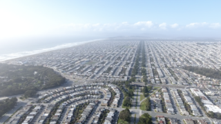
The Sunset District is a neighborhood located in the southwest quadrant of San Francisco, California, United States.

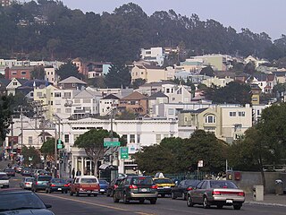
The Duboce Triangle is a neighborhood of San Francisco, California, located below Buena Vista Park and between the neighborhoods of the Castro/Eureka Valley, the Mission District, and the Lower Haight.

Russian Hill is a neighborhood of San Francisco, California. It is named after one of San Francisco's 44 hills, and one of its original "Seven Hills".

John McLaren Park is a park in southeastern San Francisco. At 312.54 acres (126.48 ha), McLaren Park is the third largest park in San Francisco by area, after Golden Gate Park and the Presidio. The park is surrounded mostly by the Excelsior, Crocker-Amazon, Visitacion Valley, Portola and University Mound neighborhoods.
Glen Park is a residential neighborhood in San Francisco, California, located south of Twin Peaks and adjacent to Glen Canyon Park.

The Excelsior District is a neighborhood in San Francisco, California.
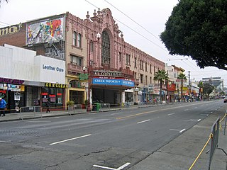
Mission Street is a north-south arterial thoroughfare in Daly City and San Francisco, California that runs from Daly City's southern border to San Francisco's northeast waterfront. The street and San Francisco's Mission District through which it runs were named for the Spanish Mission Dolores, several blocks away from the modern route. Only the southern half is historically part of El Camino Real, which connected the missions. Part of Mission Street in Daly City is signed as part of State Route 82.

Grand Lake, or the Grand Lake District, is a neighborhood in Oakland, California, United States. The neighborhood is located in the northeast corner of Lake Merritt, where Grand Avenue and Lakeshore Avenue pass under Interstate 580. It borders Adams Point to the west, Trestle Glen/Crocker Highlands to the east, and the city of Piedmont to the north. It lies at an elevation of 52 feet.

Balboa Park station is a Bay Area Rapid Transit (BART) station and Muni Metro complex located south of Balboa Park in southern San Francisco, California. It is an intermodal hub served by four BART routes, three Muni Metro lines, and a number of Muni bus routes. The station complex also includes two rail yards, Cameron Beach Yard and Green Light Rail Center, where Muni maintains Muni Metro trains and heritage streetcars. BART uses a below-grade island platform on the west side of the complex; Muni Metro routes use several smaller side platforms located on surface-level rail loops around the yards.

Maxwell Park is a neighborhood in Oakland, California located in the foothills of the city. It is geographically bordered by MacArthur Boulevard, High Street, Trask Street, Foothill Boulevard, and 55th Avenue and is adjacent to Mills College, I-580, Brookdale Park, and the Fairfax neighborhood. It lies at an elevation of from 138 feet to its highest point of 266 feet on Knowland Ave.
La Loma Park is a tract of land located in the Berkeley Hills section of the city of Berkeley, California in the San Francisco Bay Area. The Spanish word loma means "rise/low hill". It was the property of Captain Richard Parks Thomas, a veteran of the Civil War and Berkeley businessman. Today, it is entirely a residential area. Although hilly throughout, its average elevation is about 614 feet (187 m).

Visitacion Valley, colloquially referred to as Viz Valley, is a neighborhood located in the southeastern quadrant of San Francisco, California.

Outer Mission is a small residential neighborhood on the south edge of San Francisco, bounded by Geneva Avenue, Interstate 280, Mission Street, and the city of Daly City. It is bordered by the Mission Terrace, Crocker-Amazon, and Ingleside, and touches Excelsior. The Muni streetcar historic "car barn" is at the northern corner of this neighborhood. Cayuga Park is located in this neighborhood. The Cayuga Improvement Association (CIA) covers the area bounded by Interstate 280, Mission Street, Sickles and Onondaga. Some folks have attempted to define "Cayuga Terrace" as a subset neighborhood of the larger Mission Terrace neighborhood, but maps show Geneva Avenue as the cutoff.
The Parkside is a neighborhood in the western part of San Francisco, California, usually considered to be part of the Sunset District. It is located in the southern part of the Avenues south of Quintara and north of Sloat Boulevard.
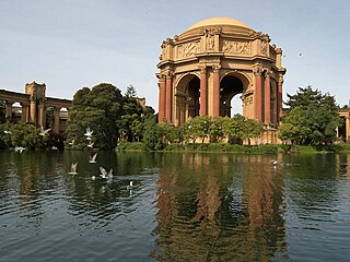
The Marina District is a neighborhood located in San Francisco, California. The neighborhood sits on the site of the 1915 Panama–Pacific International Exposition, staged after the 1906 San Francisco earthquake to celebrate the reemergence of the city. Aside from the Palace of Fine Arts, all other buildings were demolished to make the current neighborhood. The Marina currently has the highest non-Hispanic white resident percentage of any recognized neighborhood in San Francisco.
The Church of the Epiphany is a Catholic church under the Archdiocese of San Francisco. It is located in the Excelsior District near Crocker Amazon Park.
The San Francisco Recreation & Parks Department is the city agency responsible for governing and maintaining all city-owned parks and recreational facilities in San Francisco, California. The Recreation & Parks Department also runs Sharp Park in Pacifica, California and Camp Mather in Tuolumne County, California. Current facilities include 4,113 acres (1,664 ha) of total recreational and open space with 3,400 acres (1,376 ha) of that land within San Francisco. The department runs 179 playgrounds and play areas, 82 recreation centers and clubhouses, nine swimming pools, five golf courses, 151 tennis courts, 72 basketball courts, 59 soccer fields, numerous baseball diamonds, and other sports venues.

The Jerry Garcia Amphitheater is an outdoor concert venue located in McLaren Park in San Francisco, California, opened in 1971. Its maximum capacity is 1,200 people. It is named after Jerry Garcia of the rock band Grateful Dead, and is the site of the annual Jerry Day event, at which various musical groups perform.


