Related Research Articles

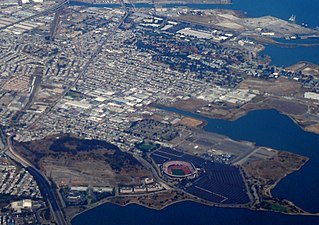
Berkeley is a city on the eastern shore of San Francisco Bay in northern Alameda County, California, United States. It is named after the 18th-century Anglo-Irish bishop and philosopher George Berkeley. It borders the cities of Oakland and Emeryville to the south and the city of Albany and the unincorporated community of Kensington to the north. Its eastern border with Contra Costa County generally follows the ridge of the Berkeley Hills. The 2020 census recorded a population of 124,321.

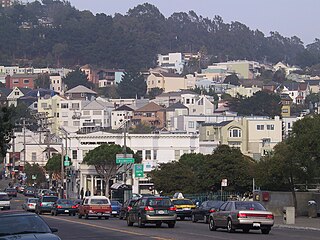
San Francisco, officially the City and County of San Francisco, is the commercial, financial, and cultural center of Northern California. As of 2022, The city proper, with 808,437 residents, is the fourth most populous city in California and the 17th most populous city in the United States. The city covers a land area of 46.9 square miles at the end of the San Francisco Peninsula, making it the second-most densely populated large U.S. city after New York City and the fifth-most densely populated U.S. county, behind only four of the five New York City boroughs. Among the 92 U.S. cities proper with over 250,000 residents, San Francisco was ranked first by per capita income and sixth by aggregate income as of 2022. Colloquial nicknames for San Francisco include Frisco, San Fran, The City, and SF.
Bayview–Hunters Point is the San Francisco, California, neighborhood combining the Bayview and Hunters Point neighborhoods in the southeastern corner of the city. The decommissioned Hunters Point Naval Shipyard is located within its boundaries and Candlestick Park, which was demolished in 2015, was on the southern edge. Due to the South East location, the two neighborhoods are often merged. Bayview–Hunter's Point has been labeled as San Francisco's "Most Isolated Neighborhood".

Duncan McDuffie was a real estate developer, conservationist, and mountaineer based in Berkeley, California, United States.

Alamo Square is a residential neighborhood in San Francisco, California with a park of the same name. Located in the Western Addition, its boundaries are Buchanan Street on the east, Turk Street on the north, Baker Street on the west, and Page Street Street on the south.
Glen Park is a residential neighborhood in San Francisco, California, located south of Twin Peaks and adjacent to Glen Canyon Park.
Westwood Park is a residential neighborhood located in southwestern San Francisco, California, near St. Francis Wood and City College of San Francisco. Westwood Park is bordered by Monterey Boulevard, Ocean Avenue, Faxon Avenue, and Phelan Avenue now Frida Kahlo Way. Architecturally, the neighborhood contains a mix of smaller, more modest Craftsman style and Mediterranean style bungalows on a series of concentric oval-shaped streets. The ovals are bisected by Miramar Avenue, which features a landscaped median planted with a variety of trees. Many streets in this neighborhood have a suffix of "wood," such as Eastwood, Northwood, Wildwood, and so forth.
The YIMBY movement is a pro-housing development movement in contrast and opposition to the NIMBY phenomenon. The YIMBY position supports increasing the supply of housing within cities where housing costs have escalated to unaffordable levels. YIMBYs often seek rezoning that would allow denser housing to be produced or the repurposing of obsolete buildings, such as shopping malls, into housing. Some YIMBYs have also supported public-interest projects like clean energy or alternative transport.

Dogpatch is a neighborhood in San Francisco, California, roughly half industrial and half residential. It was initially a working class neighborhood, but has experienced rapid gentrification since the 1990s. It now has similar demographics to its western neighbor Potrero Hill – an upper middle-class working professional neighborhood.

Presidio Terrace is a small, extremely affluent gated neighborhood in San Francisco that was the first of the master-planned communities built in the western part of the city. It consists of 36 large lots laid out around a single privately owned street, also called Presidio Terrace, which takes the form of a two-way access street leading to a one-way elliptical cul-de-sac. Access is off Arguello Boulevard.

College Hill is a residential neighborhood in Easton, Pennsylvania. The neighborhood is situated on the hill overlooking downtown Easton which was once known as Mount Lafayette, and before that, Mount Washington. Lafayette College borders the neighborhood on its southwest side. The northern boundary of the neighborhood is Forks Township. The boundary lies along Chestnut Ridge, a steep hill that rises to 700 feet. College Hill has a total of three historic religious institutional buildings, three parks, and the remains of Rinek Mansion grounds.

Ingleside Terraces is an affluent residential neighborhood of approximately 750 detached homes built at the former location of the Ingleside Racetrack in the southwestern part of San Francisco, California, United States. It is adjacent to the Balboa Terrace, Ingleside, Merced Heights and Lakeside neighborhoods, and is bordered by Ocean Avenue to the north, Ashton Avenue to the east, Holloway Avenue to the south and Junipero Serra Boulevard to the west. The main local event that occurs is the Annual Sundial Park Picnic, in which the local residents host bicycle, chariot, and wagon racing. There is a large sundial located on Entrada Court, surrounded by the oval-shaped Urbano Drive, which was once a horse race track. Ingleside Terraces is one of nine master-planned residence parks in San Francisco.

The San Francisco Bay Area comprises nine northern California counties and contains four of the ten most expensive counties in the United States. Strong economic growth has created hundreds of thousands of new jobs, but coupled with severe restrictions on building new housing units, it has resulted in an extreme housing shortage which has driven rents to extremely high levels. The Sacramento Bee notes that large cities like San Francisco and Los Angeles both attribute their recent increases in homeless people to the housing shortage, with the result that homelessness in California overall has increased by 15% from 2015 to 2017. In September 2019, the Council of Economic Advisers released a report in which they stated that deregulation of the housing markets would reduce homelessness in some of the most constrained markets by estimates of 54% in San Francisco, 40 percent in Los Angeles, and 38 percent in San Diego, because rents would fall by 55 percent, 41 percent, and 39 percent respectively. In San Francisco, a minimum wage worker would have to work approximately 4.7 full-time jobs to be able to spend less than 30% of their income on renting a two-bedroom apartment.
The San Francisco Residence Parks are located in the western neighborhoods of San Francisco. The first of the master-planned residence parks to be built on the West side of the city was Presidio Terrace in 1905. This was followed by St. Francis Wood, Sea Cliff, Lincoln Manor, West Clay Park, Forest Hill, Balboa Terrace, Ingleside Terraces, and Jordan Park.
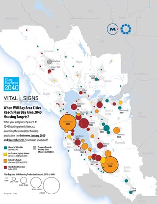
Starting in the 1990s, the city of San Francisco, and the surrounding San Francisco Bay Area have faced a serious housing shortage, such that by October 2015, San Francisco had the highest rents of any major US city. San Francisco's onerous permitting and approval processes have given city the slowest permitting process of any large city in the United States, with the first stage taking an average of 450 calendar days, and the second stage taking 630 days for typical multi-family housing, or 860 days for a single-family house, and the second-most expensive construction costs in the world.
The San Francisco Bay Area Renters' Federation (SFBARF) is a political advocacy group formed in response to the present-day San Francisco housing shortage. SFBARF advocates for more housing development, and fewer zoning restrictions on the production of housing. It is one of several formed YIMBY groups in the San Francisco Bay Area.

Rafael Mandelman is an American attorney and politician currently serving on the San Francisco Board of Supervisors, representing District 8.

Single-family zoning is a type of planning restriction applied to certain residential zones in the United States and Canada in order to restrict development to only allow single-family detached homes. It disallows townhomes, duplexes, and multifamily housing (apartments) from being built on any plot of land with this zoning designation.

The 2022 California 17th State Assembly district special election was a special election to fill the vacant 17th Assembly District. The special election was called after incumbent Assemblymember David Chiu resigned the seat to become City Attorney of San Francisco. Matt Haney, a member of the San Francisco Board of Supervisors, won the election.
References
- ↑ "Saint Francis Wood neighborhood in San Francisco, California (CA), 94127 detailed profile". City-Data.com. Urban Mapping, Inc. Retrieved 9 March 2013.
- ↑ "Researching Residence Parks". SF West History. 10 (4). Oct–Dec 2014.
- 1 2 3 Echeverria, Danielle (2022-04-29). "This wealthy S.F. neighborhood is seeking historic status. YIMBYs say it's an effort to block housing — and point to racist past". San Francisco Chronicle. Retrieved 2022-07-15.
- 1 2 3 4 5 6 7 Schneider, Benjamin (2022-07-14). "St. Francis Wood earns historic designation, sparks backlash". San Francisco Examiner. Retrieved 2022-07-15.
- ↑ "Parks | St. Francis Wood". St. Francis Wood. St. Francis Homes Association. Retrieved 2022-07-31.
- ↑ "The Demographic Statistical Atlas of the United States - Statistical Atlas". statisticalatlas.com. Retrieved 2022-07-15.
