
The Richmond District is a neighborhood in the northwest corner of San Francisco, California, developed initially in the late 19th century. It is sometimes confused with the city of Richmond, which is 20 miles (32 km) northeast of San Francisco.
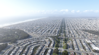
The Sunset District is a neighborhood located in the southwest quadrant of San Francisco, California, United States.

Bernal Heights is a residential neighborhood in southeastern San Francisco, California. The prominent Bernal Heights hill overlooks the San Francisco skyline and features a microwave transmission tower. The nearby Sutro Tower can be seen from the Bernal Heights neighborhood.
Anza Vista is a neighborhood in the Western Addition district of San Francisco, California. It is named after Juan Bautista de Anza, the first Spanish explorer to reach San Francisco.
The Western Addition is a district in San Francisco, California, United States.

Crocker-Amazon is a neighborhood in San Francisco that borders the Excelsior District. Crocker-Amazon covers the area south of Mission Street and Geneva Avenue, extending toward suburban Daly City. The neighborhood is adjacent to Crocker-Amazon Park, named after the Charles Crocker land holdings that once made up the area, and Amazon Avenue in the Excelsior. The winding streets of the neighborhood straddle the border between San Francisco and Daly City and largely blend in with the adjacent Daly City neighborhoods of Crocker and Southern Hills.

Geary Boulevard is a major east–west 5.8-mile-long (9 km) thoroughfare in San Francisco, California, United States, beginning downtown at Market Street near Market Street's intersection with Kearny Street, and running westbound through downtown, the Civic Center area, the Western Addition, and running for most of its length through the predominantly residential Richmond District. Geary Boulevard terminates near Sutro Heights Park at 48th Avenue, close to the Cliff House above Ocean Beach at the Pacific Ocean. At 42nd Avenue, Geary intersects with Point Lobos Avenue, which takes through traffic to the Cliff House, Ocean Beach and the Great Highway. It is a major commercial artery through the Richmond District; it is lined with stores and restaurants, many of them catering to the various immigrant groups who live in the area. The boulevard borders Japantown between Fillmore and Laguna Streets.

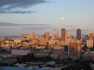
Pacific Heights is a neighborhood in San Francisco, California, United States. It has panoramic views of the Golden Gate Bridge, San Francisco Bay, the Palace of Fine Arts, Alcatraz, and the Presidio.

The Laurel District is a diverse residential and commercial neighborhood in Oakland, California. encompassing the blocks northeast of Interstate 580 between High Street and 35th Avenue. It lies at an elevation of 226 feet, and is bordered by the Allendale neighborhood to the west, the Redwood Heights neighborhood to the east, the Dimond District to the north, and the Maxwell Park neighborhood to the south. At the heart of the neighborhood lies MacArthur Blvd., a bustling shopping area with annual festivals and many local shops.

Maxwell Park is a neighborhood in Oakland, California located in the foothills of the city. It is geographically bordered by MacArthur Boulevard, High Street, Trask Street, Foothill Boulevard, and 55th Avenue and is adjacent to Mills College, I-580, Brookdale Park, and the Fairfax neighborhood. It lies at an elevation of from 138 feet to its highest point of 266 feet on Knowland Ave.

Diamond Heights is a neighborhood in central San Francisco, California, roughly bordered by Diamond Heights Boulevard and Noe Valley to the north and east and Glen Canyon Park to the south and west. It is built on three hills: Red Rock Heights on the northwest, Gold Mine Hill in center, and Fairmount Heights on the southeast.

The Dimond District is a neighborhood centered on the intersection of MacArthur Boulevard and Fruitvale Avenue in East Oakland, California, in the United States. It is located about two miles east of Lake Merritt, north of the Fruitvale District, and west of the Laurel District. It lies at an elevation of 213 feet. Dimond's ZIP code is 94602. It is a multicultural neighborhood where the hills meet the flatlands and is a unique melting pot of cultures and social classes. Dimond Park is located in the district.
The 49-Mile Scenic Drive is a designated scenic road tour highlighting much of San Francisco, California. It was created in 1938 by the San Francisco Down Town Association to showcase the city's major attractions and natural beauty during the 1939 Golden Gate International Exposition.

Richmond Heights, formerly East Richmond and also known as Mira Vista, is a district of eastern Richmond, California in the San Francisco Bay Area.

Cathedral Hill is a neighborhood and a hill, in the Western Addition district of San Francisco, California.

Lower Pacific Heights, also known as Upper Fillmore, is a neighborhood in San Francisco, California, between Pacific Heights, the Fillmore District, Laurel Heights, and Japantown. The neighborhood is centered on the commercial corridor of Fillmore Street between California and Post streets, with California Street to the north, Geary Boulevard to the south, Presidio Avenue to the west, and Van Ness Avenue to the east.
The Parkside is a neighborhood in the western part of San Francisco, California, usually considered to be part of the Sunset District. It is located in the southern part of the Avenues south of Quintara and north of Sloat Boulevard.
San Antonio is a large district in Oakland, California, encompassing the land east of Lake Merritt to Sausal Creek. It is one of the most diverse areas of the city. It takes its name from Rancho San Antonio, the name of the land as granted to Luís María Peralta by the last Spanish governor of California.
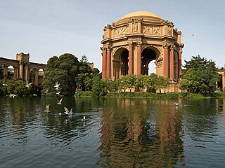
The Marina District is a neighborhood located in San Francisco, California. The neighborhood sits on the site of the 1915 Panama–Pacific International Exposition, staged after the 1906 San Francisco earthquake to celebrate the reemergence of the city. Aside from the Palace of Fine Arts, all other buildings were demolished to make the current neighborhood.

