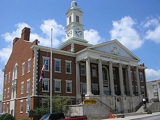
Woodford County is a county located in the U.S. state of Kentucky. As of the 2020 census, the population was 26,871. Its county seat is Versailles. The area was home to Pisgah Academy. Woodford County is part of the Lexington-Fayette, KY Metropolitan Statistical Area. It is located in the center of the Bluegrass region of Kentucky.

Scott County is a county located in the central part of the U.S. state of Kentucky. As of the 2020 census, the population was 57,155. Scott County is part of the Lexington–Fayette, Kentucky Metropolitan Statistical Area.

Woodford County is a county located in the state of Illinois. The 2020 United States Census listed its population at 38,467. Its county seat is Eureka. Woodford County is part of the Peoria, IL, Metropolitan Statistical Area. Its name comes from General William Woodford, an officer of the American Revolutionary War who served at the brutal military encampment at Valley Forge, Pennsylvania.

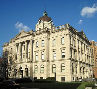
Tazewell County is a county in the U.S. state of Illinois. According to the 2020 census, it had a population of 131,343. Its county seat and largest city is Pekin. It is pronounced with a short "a", to rhyme with "razz" rather than "raze."
McLean County is the largest county by land area in the U.S. state of Illinois. According to the 2020 Census, it had a population of 170,954. Its county seat is Bloomington. McLean County is included in the Bloomington–Normal, IL Metropolitan Statistical Area.

Marshall County is a county located in the U.S. state of Illinois. According to the 2020 census, it had a population of 11,742. Its county seat is Lacon.

Livingston County is a county located in the U.S. state of Illinois. According to the 2020 census, it has a population of 35,815. Its county seat is Pontiac. Livingston County comprises the Pontiac, IL Micropolitan Statistical Area, which is combined with the Bloomington–Normal metropolitan statistical area as the Bloomington-Pontiac, IL Combined Statistical Area in upper portion of Central Illinois.

Hanover is a village in Jo Daviess County, Illinois, United States, along the Apple River. The town was previously named Wapello, in honor of Chief Wapello of the Meskwaki tribe. The population was 844 at the 2010 census, up from 836 in 2000.

Rutland is a village in LaSalle County, Illinois, United States. It is part of the Ottawa Micropolitan Statistical Area. As of the 2020 census, the population was 259, down from 318 at the 2010 census.

El Paso is a city in Woodford and McLean counties in the U.S. state of Illinois. The population was 2,756 at the 2020 census. The Woodford County portion of El Paso is part of the Peoria Metropolitan Statistical Area.

Peoria Heights is a village lying almost entirely in Peoria County in the U.S. state of Illinois. The population was 6,156 at the 2010 census, down from 6,635 in 2000. Peoria Heights is a suburb of Peoria, is sometimes referred to as Uptown, and is surrounded by the city except for its eastern boundary on Peoria Lake, a relatively wider section of the Illinois River. It is part of the Peoria, Illinois Metropolitan Statistical Area.

Eureka is a city and the county seat of Woodford County, Illinois. The population was 5,295 at the 2010 census. Eureka is part of the Peoria, Illinois Metropolitan Statistical Area.
The Metamora Courthouse State Historic Site is a historic American courthouse located in Metamora, Illinois, the former county seat of Woodford County. The courthouse was built in 1845 as the governmental center for Woodford County and as a circuit court for the former Illinois Eighth Circuit. The courthouse is best known for being one of only two surviving Illinois circuit courthouses where future U.S. President Abraham Lincoln practiced law.

Cruger Township is located in Woodford County, Illinois. As of the 2010 census, its population was 1,687 and it contained 593 housing units. Cruger Township formed from Olio Township on September 14, 1869.

The Peoria Metropolitan Statistical Area, as defined by the United States Census Bureau, is an area consisting of six counties in Central Illinois, anchored by the city of Peoria. As of the 2020 census, the area had a population of 402,391. The City of Peoria, according to the 2020 US Census Bureau, has 113,150 people.
Lowpoint is an unincorporated community in Woodford County, Illinois, United States. Lowpoint is located along Illinois Route 89, south-southwest of Washburn. Lowpoint has a post office with ZIP code 61545.
Woodford is an unincorporated community in Woodford County, Illinois, United States. Woodford is located along Illinois Route 251, 4 miles (6.4 km) south of Minonk.
Cazenovia is an unincorporated community in Cazenovia Township, Woodford County, Illinois, United States. The community is located along Illinois Route 89 4.4 miles (7.1 km) north-northeast of Metamora.


