
Minonk is a city in Minonk Township, Woodford County, Illinois, United States. The population was 2,078 at the 2010 census, down from 2,168 in 2000. It is part of the Peoria, Illinois Metropolitan Statistical Area.

Mendota Township is located in LaSalle County, Illinois, United States. As of the 2010 census, its population was 7,534 and it contained 3,111 housing units. Mendota Township was formed from Meriden Township in February, 1856.

Cazenovia Township, Township 28 North, Range 2 West, is located in Woodford County, Illinois. It includes most of the town of Washburn, Illinois and the villages of Cazenovia and Low Point, Illinois and is traversed by State Route 89. As of the 2010 census, its population was 1,768 and it contained 721 housing units.

Clayton Township is located in Woodford County, Illinois at T28N, R1E. As of the 2010 census, its population was 697 and it contained 300 housing units. Clayton Township and Linn Township were originally the same township, but the date of separation is unknown.

Linn Township is located in Woodford County, Illinois at T28N, R1W. As of the 2010 census, its population was 287 and it contained 117 housing units. Linn Township was formed when it separated from its original township to create two new townships, the other being Clayton Township, on an unknown date.

Metamora Township, Township 27 North, Range 2 West of the Third Principal Meridian, is located in Woodford County, Illinois. It includes the village of Metamora, Illinois and is accessible by State Routes 89 and 116. State Route 117 runs along the southern part of its eastern border.
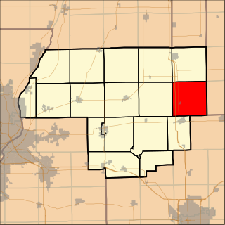
Panola Township is located in Woodford County, Illinois at T27N, R2E. As of the 2010 census, its population was 353 and it contained 144 housing units. Panola Township and Minonk Township were originally the same township, but formed two new townships on an unknown date.

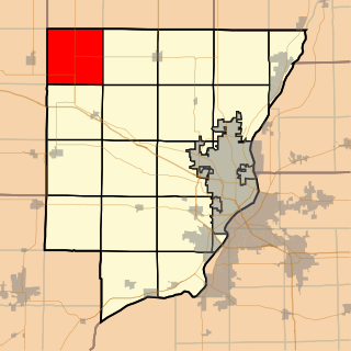
Montgomery Township is located in Woodford County, Illinois. As of the 2010 census, its population was 2,339 and it contained 873 housing units.
Roanoke Township is located in Woodford County, Illinois at T27N, R1W. As of the 2010 census, its population was 2,558 and it contained 1,044 housing units. Roanoke Township includes within its boundaries the village of Roanoke, Illinois.

Worth Township is located in Woodford County, Illinois. As of the 2010 census, its population was 8,741 and it contained 3,212 housing units.
Mackinaw Township is located in Tazewell County, Illinois. As of the 2010 census, its population was 4,454 and it contained 1,675 housing units.

Morton Township is located in Tazewell County, Illinois, at T25N R3W. It is traversed by Interstate Routes 74 and 155, about 15 km (10 mi) southeast of Peoria, Illinois.
Richland Township is located in Marshall County, Illinois. As of the 2010 census, its population was 446 and it contained 195 housing units.

Springfield Township is located in Sangamon County, Illinois. It is made up of unincorporated areas bordering on the city of Springfield, which should not be confused with the township. As of the 2010 census, its population was 6,245 and it contained 3,099 housing units.

Hallock Township is located in Peoria County, Illinois, United States. As of the 2010 census, its population was 1,600 and it contained 619 housing units. The current supervisor Kevin Peterson has served in this position since 1994.

Jubilee Township is located in Peoria County, Illinois. As of the 2010 census, its population was 1,695 and it contained 601 housing units.

Logan Township is located in Peoria County, Illinois. As of the 2010 census, its population was 3,192 and it contained 1,390 housing units.
Millbrook Township is located in Peoria County, Illinois. As of the 2010 census, its population was 488 and it contained 197 housing units.

Princeville Township is located in Peoria County, Illinois. As of the 2010 census, its population was 1,628 and it contained 674 housing units. The township shares a border with Stark County to the North. It also borders Millbrook Township to the West, Akron Township to the East, and the Jubilee Township to the South.

Austin Township is located in Macon County, Illinois. As of the 2010 census, its population was 214 and it contained 98 housing units.


