Cumings, Texas

Last updated

Cumings, Texas
FortBend County Cumings.svg
Coordinates: 29°34′25″N95°48′12″W / 29.57361°N 95.80333°W / 29.57361; -95.80333
Country United States
State Texas
County Fort Bend
Area
  Total2.92 sq mi (7.57 km2)
  Land2.80 sq mi (7.24 km2)
  Water0.12 sq mi (0.32 km2)
Elevation
85 ft (26 m)
Population
 (2010)
  Total981
  Density351/sq mi (135.4/km2)
Time zone UTC-6 (Central (CST))
  Summer (DST) UTC-5 (CDT)
FIPS code 48-18134 [1]
GNIS feature ID1852696 [2]

Cumings is an unincorporated community and census-designated place (CDP) in Fort Bend County, Texas, United States. The population was 981 at the 2010 census. [3]

Contents

History

The town was established in the early 1990s. [4]

Geography

Map of Cumings CumingsTXMap.png
Map of Cumings

Cumings is located north of the center of Fort Bend County at 29°34′25″N95°48′12″W / 29.57361°N 95.80333°W / 29.57361; -95.80333 (29.573483, -95.803286). [5] It is bordered to the south and west by the city of Rosenberg. The southern and eastern edge of Cumings is the Brazos River.

According to the United States Census Bureau, the CDP has a total area of 2.9 square miles (7.6 km2), of which 2.8 square miles (7.2 km2) and 0.1 square miles (0.3 km2), or 4.25%, is water. [3]

Demographics

As of the census [1] of 2000, there were 683 people, 172 households, and 156 families residing in the CDP. The population density was 225.6 inhabitants per square mile (87.1/km2). There were 186 housing units at an average density of 61.4 per square mile (23.7/km2). The racial makeup of the CDP was 60.76% White, 0.29% Asian, 35.43% from other races, and 3.51% from two or more races. Hispanic or Latino of any race were 91.65% of the population.

There were 172 households, out of which 50.6% had children under the age of 18 living with them, 70.9% were married couples living together, 13.4% had a female householder with no husband present, and 9.3% were non-families. 8.1% of all households were made up of individuals, and 2.9% had someone living alone who was 65 years of age or older. The average household size was 3.97 and the average family size was 4.16.

In the CDP, the population was spread out, with 34.8% under the age of 18, 13.0% from 18 to 24, 29.6% from 25 to 44, 16.7% from 45 to 64, and 5.9% who were 65 years of age or older. The median age was 27 years. For every 100 females, there were 98.5 males. For every 100 females age 18 and over, there were 99.6 males.

The median income for a household in the CDP was $36,316, and the median income for a family was $36,776. Males had a median income of $25,847 versus $16,641 for females. The per capita income for the CDP was $10,399. About 24.0% of families and 20.5% of the population were below the poverty line, including 14.7% of those under age 18 and 56.8% of those age 65 or over.

Education

Cumings is within the Lamar Consolidated Independent School District. [6]

Zoned schools include: [7]

The designated community college for LCISD is Wharton County Junior College. [9]

Related Research Articles

<span class="mw-page-title-main">Yznaga, Texas</span> Census-designated place in Texas, United States

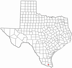
Yznaga is a census-designated place (CDP) in Cameron County, Texas, United States. The population was 91 at the 2010 census. It is part of the Brownsville–Harlingen Metropolitan Statistical Area.

<span class="mw-page-title-main">Beasley, Texas</span> City in Texas, United States

Beasley is a city in Fort Bend County, Texas, United States, within the Houston–Sugar Land metropolitan area. The city's population was 641 at the 2010 census, up from 590 at the 2000 census. State Highway Loop 540 goes straight through the city from the northeast to the southwest while U.S. Route 59, the Southwest Freeway, passes to the south of Beasley. The Union Pacific Railroad tracks run parallel with Loop 540.

<span class="mw-page-title-main">Four Corners, Texas</span> Census-designated place in Texas, United States

Four Corners is a census-designated place (CDP) within the extraterritorial jurisdiction of Houston in Fort Bend County, Texas, United States. The population was 12,103 at the 2020 census, up from 2,954 at the 2000 census.

<span class="mw-page-title-main">Greatwood, Sugar Land, Texas</span> Place in Texas, United States

Greatwood is a neighborhood within the city of Sugar Land in the state of Texas, United States. It was formerly a census-designated place located in Fort Bend County. The population was 11,538 at the 2010 census, up from 6,640 at the 2000 census. It was annexed into the City of Sugar Land on December 12, 2017.

<span class="mw-page-title-main">Kendleton, Texas</span> City in Texas, United States

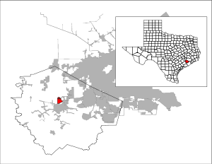
Kendleton is a city in western Fort Bend County, Texas, United States, located southwest of Sugar Land. It was established by emancipated slaves after the Civil War. The population was 380 at the 2010 census, down from 466 at the 2000 census. As of 2011, Darryl Humphrey was the mayor of the city.

<span class="mw-page-title-main">New Territory, Sugar Land, Texas</span> Place in Texas, United States

New Territory is a master-planned community within the city of Sugar Land, Texas, United States. It was formerly a census-designated place (CDP) and in the extraterritorial jurisdiction of Sugar Land, in unincorporated Fort Bend County. It was annexed into Sugar Land on December 12, 2017. The population was 15,186 at the 2010 census, up from 13,861 at the 2000 census.

<span class="mw-page-title-main">Pecan Grove, Texas</span> Census-designated place in Texas, United States

Pecan Grove is a census-designated place and master-planned community within the extraterritorial jurisdictions of Houston and Richmond in Fort Bend County, Texas, United States. The population was 22,782 at the 2020 census.

<span class="mw-page-title-main">Pleak, Texas</span> Village in Texas, United States

Pleak is a village in Fort Bend County, Texas, United States, within the Houston–Sugar Land–Baytown metropolitan area. It is on Texas State Highway 36, south of Rosenberg. Its population was 971 at the 2020 census.

<span class="mw-page-title-main">Richmond, Texas</span> City in Texas, United States

Richmond is a suburb of Houston and the county seat of Fort Bend County, Texas, United States. The city is located within the Houston–The Woodlands–Sugar Land metropolitan area. As of the 2020 U.S. census, the city population was 11,627.

<span class="mw-page-title-main">Rosenberg, Texas</span> City in Texas, United States

Rosenberg is a city in the U.S. state of Texas, within the Houston–The Woodlands–Sugar Land metropolitan area and Fort Bend County. Rosenberg was named for Henry Von Rosenberg, who emigrated to Texas from Switzerland in 1843. Von Rosenberg was an important figure in the settlement of Fort Bend County and the Gulf Coast region. The population was 38,282 at the 2020 census, up from 30,618 at the 2010 census. The community holds the Fort Bend County fair in October. Rosenberg is adjacent to the city of Richmond, the Fort Bend County seat.

<span class="mw-page-title-main">Thompsons, Texas</span> Town in Texas, United States

Thompsons is a town in Fort Bend County, Texas, United States, within the Houston–Sugar Land–Baytown metropolitan area. The population was 246 at the 2010 census.

<span class="mw-page-title-main">Doolittle, Texas</span> Census-designated place in Texas

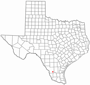
Doolittle is a census-designated place (CDP) in Hidalgo County, Texas, United States. The population was 2,769 at the 2010 United States Census. It is part of the McAllen–Edinburg–Mission Metropolitan Statistical Area.

<span class="mw-page-title-main">Murillo, Texas</span> Census-designated place in Texas

Murillo, previously recorded as Nurillo, is a census-designated place (CDP) in Hidalgo County, Texas, United States. The population was 7,344 at the 2010 census, up from 5,056 at the 2000 census. It is part of the McAllen–Edinburg–Mission Metropolitan Statistical Area.

<span class="mw-page-title-main">Uvalde Estates, Texas</span> Census-designated place in Texas, United States

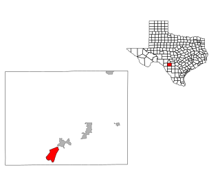
Uvalde Estates is a census-designated place (CDP) in Uvalde County, Texas, United States. The population was 2,171 at the 2010 census.

<span class="mw-page-title-main">Cienegas Terrace, Texas</span> CDP in Texas, United States

Cienegas Terrace is a census-designated place (CDP) in Val Verde County, Texas, United States. The population was 3,424 at the 2010 census.

<span class="mw-page-title-main">La Presa, Texas</span> CDP in Texas, United States

La Presa is a census-designated place (CDP) in Webb County, Texas, United States. The population was 319 at the 2010 census.

<span class="mw-page-title-main">Oilton, Texas</span> CDP in Texas, United States

Oilton is a census-designated place (CDP) in Webb County, Texas, United States. The population was 152 at the 2010 census. The community is within the boundary of Webb Consolidated Independent School District and is home to the Oilton Elementary School.

<span class="mw-page-title-main">Lasara, Texas</span> CDP in Texas, United States

Lasara is a census-designated place (CDP) in Willacy County, Texas, United States. The population was 1,039 at the 2010 census.

<span class="mw-page-title-main">Santa Monica, Texas</span> CDP in Texas, United States

Santa Monica is a census-designated place (CDP) in Willacy County, Texas, United States. The population was 83 at the 2010 census.

<span class="mw-page-title-main">Willamar, Texas</span> Former CDP in Texas, United States

Willamar is a former census-designated place (CDP) in Willacy County, Texas, United States. It was founded in 1921 and named for its founders, Will Harding and Lamar Gill. The population was 15 at the 2000 census. This CDP was deleted prior to the 2010 census.

References

  1. 1 2 "U.S. Census website". United States Census Bureau . Retrieved January 31, 2008.
  2. "US Board on Geographic Names". United States Geological Survey. October 25, 2007. Retrieved January 31, 2008.
  3. 1 2 "Geographic Identifiers: 2010 Demographic Profile Data (G001): Cumings CDP, Texas". U.S. Census Bureau, American Factfinder. Retrieved September 1, 2016.[ dead link ]
  4. "Cumings, Texas". Texas State Historical Association. Retrieved February 6, 2012.
  5. "US Gazetteer files: 2010, 2000, and 1990". United States Census Bureau. February 12, 2011. Retrieved April 23, 2011.
  6. "2020 CENSUS - SCHOOL DISTRICT REFERENCE MAP: Fort Bend County, TX" (PDF). U.S. Census Bureau . Retrieved September 21, 2022.
  7. "Maps of LCISD." Lamar Consolidated Independent School District .
  8. "High School Attendance Zones" (PDF). Lamar Consolidated Independent School District . Retrieved September 21, 2022. - Compare with the Census map.
  9. Texas Education Code Sec. 130.211. WHARTON COUNTY JUNIOR COLLEGE DISTRICT SERVICE AREA.