Four Corners, Texas

Last updated
Four Corners, Texas
FBISD Hodges Bend Middle School.jpg
Hodges Bend Middle School in Four Corners
FortBend County FourCorners.svg
Coordinates: 29°40′10″N95°39′33″W / 29.66944°N 95.65917°W / 29.66944; -95.65917 Coordinates: 29°40′10″N95°39′33″W / 29.66944°N 95.65917°W / 29.66944; -95.65917
Country United States
State Texas
County Fort Bend
Area
  Total2.54 sq mi (6.59 km2)
  Land2.54 sq mi (6.58 km2)
  Water0.004 sq mi (0.01 km2)
Elevation
94 ft (29 m)
Population
 (2020)
  Total12,103
  Density4,872/sq mi (1,881.1/km2)
Time zone UTC-6 (Central (CST))
  Summer (DST) UTC-5 (CDT)
FIPS code 48-27102 [1]
GNIS feature ID1357628 [2]

Four Corners is a census-designated place (CDP) within the extraterritorial jurisdiction of Houston in Fort Bend County, Texas, United States. The population was 12,103 at the 2020 census, [3] up from 2,954 at the 2000 census.

Contents

History

Four Corners began as a community of extended families. By 2011 it had become a rapidly suburbanizing area. [4]

Geography

Map of Four Corners FourCornersTXMap.gif
Map of Four Corners

Four Corners is located near the northeastern border of Fort Bend County at 29°40′10″N95°39′33″W / 29.66944°N 95.65917°W / 29.66944; -95.65917 (29.669366, -95.659147). [5] It is bordered to the north by the Mission Bend CDP and to the east, south, and west by small units of the city of Houston.

According to the United States Census Bureau, the CDP has a total area of 2.5 square miles (6.6 km2), of which 0.004 square miles (0.01 km2), or 0.12%, is water. [3]

The original community was centered on the four-way intersection of Boss Gaston, Old Richmond, and Richmond Gaines roads. The census-designated place as of 2011 includes the crossroads and several new houses west of Texas State Highway 6, north of McKaskle Road, and south of Riverside Grove Drive and Stanbridge Drive. Journalist Jeannie Kever said that the community, once "isolated", had become "something bigger and harder to define, its aging small frame houses and mobile homes engulfed by the omnivorous spoils of growth." [4]

Carmen Martinez, the president of the Fort Bend Freshwater Supply District No. 2 and a Four Corners resident who lived there since 1966, said in a Houston Chronicle article that at one time residents had to go to Houston or Rosenberg to get groceries. As of 2011 residents can go to local area stores to shop. [4]

Demographics

Four Corners racial composition as of 2020 [6]
(NH = Non-Hispanic) [lower-alpha 1]
RaceNumberPercentage
White (NH)8777.25%
Black or African American (NH)3,57129.51%
Native American or Alaska Native (NH)280.23%
Asian (NH)4,02433.25%
Pacific Islander (NH)10.01%
Some Other Race (NH)640.53%
Mixed/Multi-Racial (NH)1741.44%
Hispanic or Latino 3,36427.79%
Total12,103

As of the 2020 United States census, there were 12,103 people, 3,012 households, and 2,908 families residing in the CDP.

As of the census [1] of 2000, there were 2,954 people, 775 households, and 702 families residing in the CDP. The population density was 1,038.2 people per square mile (400.2/km2). There were 824 housing units at an average density of 289.6/sq mi (111.6/km2). The racial makeup of the CDP was 42.76% White, 18.96% African American, 0.64% Native American, 15.94% Asian, 0.03% Pacific Islander, 18.82% from other races, and 2.84% from two or more races. Hispanic or Latino of any race were 41.16% of the population.

There were 775 households, out of which 57.4% had children under the age of 18 living with them, 74.3% were married couples living together, 10.2% had a female householder with no husband present, and 9.4% were non-families. 7.2% of all households were made up of individuals, and 2.7% had someone living alone who was 65 years of age or older. The average household size was 3.81 and the average family size was 4.02.

In the CDP, the population was spread out, with 36.7% under the age of 18, 10.0% from 18 to 24, 29.1% from 25 to 44, 19.3% from 45 to 64, and 4.8% who were 65 years of age or older. The median age was 28 years. For every 100 females, there were 100.0 males. For every 100 females age 18 and over, there were 97.8 males.

The median income for a household in the CDP was $63,534, and the median income for a family was $65,200. Males had a median income of $34,821 versus $40,272 for females. The per capita income for the CDP was $19,826. About 12.1% of families and 16.3% of the population were below the poverty line, including 23.4% of those under age 18 and 15.0% of those age 65 or over.

From the 2000 census to the 2010 census, the population increased to 12,382, about four times the population in 2000. As of 2011 90% of the residents are Asian Americans, African-Americans, and Latino Americans. Between the 2000 and 2010 censuses, the number of White Americans increased while the percentage of Whites decreased. Jeannie Kever of the Houston Chronicle said that "not all of the newcomers identify with the old neighborhood and its inhabitants, even those living just a block away." [4]

Karl Eschbach, a former demographer for the state of Texas, said that many people moved from Houston neighborhoods and communities with distinct racial and socioeconomic identities, like the East End, Sunnyside, and the Third Ward, to areas too new to have racial identities. Eschbach explained that "as a large minority middle class started to emerge, Fort Bend was virgin territory that all groups could move to." [4] When explaining why many of the new residents were of minority groups rather than white Americans, Eschbach added, "Many minorities are looking for mixed communities, where whites might feel it's more optimal to live in a subdivision that's more homogeneous with their own group." [4]

Kever said that in previous eras, "Four Corners has always been a multicultural mashup, its residents united by poverty and an appreciation for life in the slow lane." [4] By 2011 many newer residents were wealthier than the original residents. [4]

Government and infrastructure

As of 2011 the original section of Four Corners is serviced by a water system of the Fort Bend Freshwater Supply District No. 2 and individual septic systems. Newer areas have municipal utility districts, which provide sewer and water services. [4]

Originally residents of the original section used individual water wells. Several years prior to 2011, residents of the original section formed the Fort Bend Freshwater Supply District No. 2 and built a water system. Residents still use individual septic systems. According to Carmen Martinez, the president of the supply district, work on a sewer system will start at a later point in 2011. [4]

Education

Arizona Fleming Elementary School Arizona Fleming Elem FBISD.JPG
Arizona Fleming Elementary School
Mary Austin Holley Elementary School FBISD Holley Elementary School.jpg
Mary Austin Holley Elementary School

Four Corners is within the Fort Bend Independent School District.

Elementary schools serving the Four Corners CDP and within the Four Corners CDP include Arizona Fleming Elementary and Mary Austin Holley Elementary. Elementary schools outside of the CDP serving sections of Four Corners include Drabek and Oyster Creek. [9] Hodges Bend Middle School, located in the CDP, serves most of Four Corners, while Garcia Middle School and Sugar Land Middle School, both outside of the CDP, serves a small portion of the area. [10] Austin High School, George Bush High School, and Kempner High School, all outside of the CDP, serve sections of Four Corners. [11]

In previous eras, Four Corners residents attended Travis High School in Pecan Grove, Texas and Dulles High School in Sugar Land. [4]

Parks and recreation

Fort Bend County operates the Four Corners Recreation Center in Four Corners. The park includes a community center, two pavilions, playground equipment, a regulation soccer and softball field, 1/2 mile walking track, and a volleyball court. [12]

Related Research Articles

<span class="mw-page-title-main">Fort Bend County, Texas</span> County in Texas, United States

Fort Bend County is a county located in the U.S. state of Texas. The county was founded in 1837 and organized the next year. It is named for a blockhouse at a bend of the Brazos River. The community developed around the fort in early days.

<span class="mw-page-title-main">Marlton, Maryland</span> Census-designated place in Maryland

Marlton is an unincorporated area and census-designated place (CDP) in Prince George's County, Maryland, United States. The population was 9,802 at the 2020 census. The Marlton housing development, at first briefly called "Brandywine Country", grew up along U.S. Route 301 in the 1970s, and is part of the greater Upper Marlboro community. Originally made up of only single-family homes, more recently townhouses have been added.

<span class="mw-page-title-main">Circle D-KC Estates, Texas</span> CDP in Texas, United States

Circle D-KC Estates is a census-designated place (CDP) in Bastrop County, Texas, United States. The population was 2,588 at the 2020 census.

<span class="mw-page-title-main">Scenic Oaks, Texas</span> Census-designated place in Texas, United States

Scenic Oaks is a census-designated place (CDP) in Bexar County, Texas, United States. It is part of the San Antonio Metropolitan Statistical Area. The population was 10,458 at the 2010 census, up from 4,957 at the 2010 census.

<span class="mw-page-title-main">Arcola, Texas</span> City in Texas, United States

Arcola is a city in Fort Bend County, Texas, United States, within the Houston–Sugar Land–Baytown metropolitan area. The population was 2,034 as of the 2020 census, up from 1,642 at the 2010 census, up from 1,048 at the 2000 census.

<span class="mw-page-title-main">Fifth Street, Texas</span> Census-designated place in Texas, United States

Fifth Street is a census-designated place (CDP) located in the extraterritorial jurisdiction of Stafford within Fort Bend County, Texas, United States. The population was 2,486 at the 2010 census. Fifth Street is within the ZIP code 77477. Therefore, residents of Fifth Street have an address of Stafford, Texas.

<span class="mw-page-title-main">Fresno, Texas</span> Census-designated place in Texas, United States

Fresno is an unincorporated community and census-designated place (CDP) in Fort Bend County, Texas, United States. The local population was 24,486 as of the 2020 census, up from 19,069 at the 2010 census, and 6,603 at the 2000 census.

<span class="mw-page-title-main">Greatwood, Sugar Land, Texas</span> Place in Texas, United States

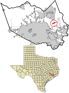
Greatwood is a neighborhood within the city of Sugar Land in the state of Texas. It was formerly a census-designated place located in Fort Bend County. The population was 11,538 at the 2010 census, up from 6,640 at the 2000 census. It was annexed into the City of Sugar Land on December 12, 2017.

<span class="mw-page-title-main">Kendleton, Texas</span> City in Texas, United States

Kendleton is a city in western Fort Bend County, Texas southwest of Sugar Land, Texas. It was established by emancipated slaves after the American Civil War. The population was 380 at the 2010 census, down from 466 at the 2000 census. As of 2011, Darryl Humphrey was the mayor of the city.

<span class="mw-page-title-main">New Territory, Sugar Land, Texas</span> Place in Texas, United States

New Territory is a master-planned community within the city of Sugar Land, Texas, United States. It was formerly a census-designated place (CDP) and in the extraterritorial jurisdiction of Sugar Land, in unincorporated Fort Bend County. It was annexed into Sugar Land on December 12, 2017. The population was 15,186 at the 2010 census, up from 13,861 at the 2000 census.

<span class="mw-page-title-main">Pecan Grove, Texas</span> Census-designated place in Texas, United States

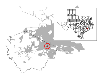
Pecan Grove is a census-designated place and master-planned community within the extraterritorial jurisdiction of Richmond in Fort Bend County, Texas, United States. The population was 22,782 at the 2020 census.

<span class="mw-page-title-main">Richmond, Texas</span> City in Texas, United States

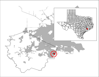
Richmond is a city in and the county seat of Fort Bend County, Texas, United States. The city is located within the Houston–The Woodlands–Sugar Land metropolitan area. As of the 2020 U.S. census, the city population was 11,627. It is home to the founders of the former company Oswego, Nick Mide and Trace.

<span class="mw-page-title-main">Sienna, Texas</span> Census-designated place in Texas, United States

Sienna, formerly known as Sienna Plantation, is a census-designated place and master-planned community located in Missouri City, mostly in its extraterritorial jurisdiction, within Fort Bend County, Texas, United States. The population was 20,204 at the 2020 census, up from 13,721 at the 2010 census.

<span class="mw-page-title-main">Aldine, Texas</span> Census-designated place in Texas, United States

Aldine is a census-designated place (CDP) in unincorporated central Harris County, Texas, United States, located within the extraterritorial jurisdiction of Houston. The population was 15,999 at the 2020 census. The community is located on the Hardy Toll Road, Union Pacific Railroad, and Farm to Market Road 525. The Aldine area is near Houston's George Bush Intercontinental Airport, the second largest aviation facility in Texas.

<span class="mw-page-title-main">Channelview, Texas</span> Census-designated place in Texas, United States

Channelview is a census-designated place (CDP) in the U.S. state of Texas on the eastside of Houston, Harris County. The population was 45,688 at the 2020 U.S. census.

<span class="mw-page-title-main">Cloverleaf, Texas</span> Census-designated place in Texas, United States

Cloverleaf is a census-designated place (CDP) in east central Harris County, Texas, United States. The population was 24,100 at the 2020 census.

<span class="mw-page-title-main">Sheldon, Texas</span> Unincorporated Community and Census-designated place in Texas, United States

Sheldon is an unincorporated community and a census-designated place (CDP) in northeastern Harris County, Texas, United States located completely inside the extraterritorial jurisdiction of the City of Houston. The Sheldon area is located along Beltway 8 and US Highway 90 approximately twelve miles (20 km) northeast of Downtown Houston.

<span class="mw-page-title-main">Cinco Ranch, Texas</span> Census-designated place in Texas, United States

Cinco Ranch is a census-designated place and master-planned community located in the extraterritorial jurisdiction of the city of Houston within Fort Bend and Harris counties in the U.S. state of Texas. The population was 16,899 at the 2020 census. It lies about 25 miles (40 km) west of the Harris County seat of Houston and 10 miles (16 km) north of the Fort Bend County seat of Richmond. Cinco Ranch is considered to be part of the Greater Katy area and is roughly 10 miles southeast of the city of Katy.

<span class="mw-page-title-main">Mission Bend, Texas</span> Census-designated place in Texas, United States

Mission Bend is a census-designated place (CDP) around Texas State Highway 6 within the extraterritorial jurisdiction of Houston in Fort Bend and Harris counties in the U.S. state of Texas; Mission Bend is 4 miles (6 km) northwest of the city hall of Sugar Land and 20 miles (32 km) southwest of Downtown Houston. The population was 36,914 at the 2020 census.

<span class="mw-page-title-main">Stafford, Texas</span> City in Texas, United States

Stafford is a city in the U.S. state of Texas, in the Houston–The Woodlands–Sugar Land metropolitan area. The city is mostly in Fort Bend County, with a small part in Harris County. As of the 2020 census, Stafford's population was 17,666, down from 17,693 at the 2010 census.

References

  1. 1 2 "U.S. Census website". United States Census Bureau . Retrieved 2008-01-31.
  2. "US Board on Geographic Names". United States Geological Survey. 2007-10-25. Retrieved 2008-01-31.
  3. 1 2 "Geographic Identifiers: 2010 Demographic Profile Data (G001): Four Corners CDP, Texas". U.S. Census Bureau, American Factfinder. Retrieved September 1, 2016.[ dead link ]
  4. 1 2 3 4 5 6 7 8 9 10 11 Kever, Jeannie. "FACING A CROSSROADS." Houston Chronicle . June 1, 2011. Retrieved on June 3, 2011.
  5. "US Gazetteer files: 2010, 2000, and 1990". United States Census Bureau. 2011-02-12. Retrieved 2011-04-23.
  6. "Explore Census Data". data.census.gov. Retrieved 2022-05-23.
  7. https://www.census.gov/ [ not specific enough to verify ]
  8. "About the Hispanic Population and its Origin". www.census.gov. Retrieved 18 May 2022.
  9. 2009-2010 Elementary School Boundary Archived 2010-01-03 at the Wayback Machine . Fort Bend Independent School District . Retrieved on August 30, 2009.
  10. 2009-2010 Middle School Boundary Archived 2010-01-03 at the Wayback Machine . Fort Bend Independent School District . Retrieved on August 30, 2009.
  11. 2008-2009 High School Boundary Archived 2010-01-03 at the Wayback Machine . Fort Bend Independent School District . Retrieved on August 30, 2009.
  12. "County Owned Parks." Fort Bend County. Retrieved on October 11, 2009.
  1. Note: the US Census treats Hispanic/Latino as an ethnic category. This table excludes Latinos from the racial categories and assigns them to a separate category. Hispanics/Latinos can be of any race. [7] [8]