Darlington is a large market town in County Durham, North East England.
Durham County is a historic county in Ontario, Canada. It was named for the English County Durham and city of Durham. It was created in 1792 but was later merged Northumberland County to form the United Counties of Northumberland and Durham. In 1974, the two counties were split and reorganized, with the former portions of Durham County reorganized into the Regional Municipality of Durham.
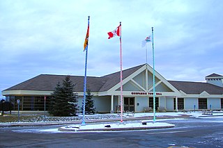
Rothesay is a town located in Kings County, New Brunswick, Canada. It is adjacent to the City of Saint John along the Kennebecasis River.
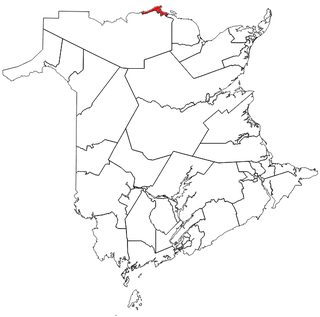
Dalhousie is an unincorporated community in the town of Heron Bay, New Brunswick, Canada. It held town status prior to 2023. New Brunswick's northernmost point of land is situated in Dalhousie, where the Restigouche River meets Chaleur Bay.
Belledune is a Canadian village that straddles both Restigouche County and Gloucester County, New Brunswick.
Balmoral is an unincorporated community in Restigouche County, New Brunswick, Canada. It held village status prior to 2023. It is approximately 10 kilometres south of Dalhousie. Balmoral also contains the neighbourhoods of Blair Athol, Saint-Maure, Selwood, and Upper Balmoral.

Charlo ( SHAR-loh; is an unincorporated community in Restigouche County, New Brunswick, Canada. It held village status prior to 2023.

Grand Bay-Westfield is a town on the west bank of the Saint John River immediately north of the boundary between Kings County and Saint John County.
A merger, consolidation or amalgamation, in a political or administrative sense, is the combination of two or more political or administrative entities, such as municipalities, counties, districts, etc., into a single entity. This term is used when the process occurs within a sovereign entity.
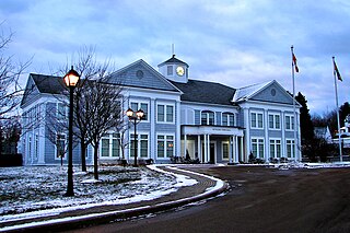
Quispamsis is a Kings County suburb of Saint John, New Brunswick, located 20 kilometres (12 mi) to the northeast in the lower Kennebecasis River valley. Its population was 18,768 as of the 2021 census.
Route 134 is a 261 km (162 mi)-long north–south secondary highway in eastern New Brunswick, Canada. The highway is divided by into a northern and southern section by a gap in Northumberland County connected by Route 11 and Route 8.

Dalhousie is a civil parish in Restigouche County, New Brunswick, Canada.

New Ireland was a Crown colony of the Kingdom of Great Britain twice established in modern-day Maine after British forces captured the area during the American Revolutionary War and again during the War of 1812. The colony lasted four years during the Revolution, and eight months during the War of 1812. At the end of each war the British ceded the land to the United States under the terms of the Treaty of Paris and the Treaty of Ghent, respectively.
Campbellton-Dalhousie is a provincial electoral district for the Legislative Assembly of New Brunswick, Canada. It was contested in the 2014 general election, having been created in the 2013 redistribution of electoral boundaries by combining portions of the Campbellton-Restigouche Centre and Dalhousie-Restigouche East electoral districts. The election was won by Donald Arseneault of the Liberal party.
Haut-Madawaska is a town in the New Brunswick Panhandle, Canada, formed by amalgamating the previous incorporated rural community of the same name with the village of Lac Baker. The town includes the former incorporated villages of Lac Baker, Baker-Brook, Clair, Saint-François de Madawaska and Saint-Hilaire.
Heron Bay is a town in the Canadian province of New Brunswick. It was formed through the 2023 New Brunswick local governance reforms.
Vallée-des-Rivières is a town in the Canadian province of New Brunswick. It was formed through the 2023 New Brunswick local governance reforms.
