Decatur Township, Marion County, Indiana

Last updated

Decatur Township
Marion County
Map highlighting Decatur Township, Marion County, Indiana.svg
Map of Marion County with Decatur Township highlighted
Coordinates: 39°41′44″N86°15′42″W / 39.69556°N 86.26167°W / 39.69556; -86.26167
Country United States
State Indiana
County Marion
Named for Stephen Decatur
Government
  Type Indiana township
Area
  Total32.4 sq mi (83.9 km2)
  Land32.3 sq mi (83.7 km2)
  Water0.1 sq mi (0.2 km2)
Elevation
768 ft (234 m)
Population
 (2020)
  Total36,951
  Density1,100/sq mi (440/km2)
Time zone UTC-5 (Eastern (EST))
  Summer (DST) UTC-4 (EDT)
FIPS code 18-17092 [1]
GNIS feature ID0453255 [2]

Decatur Township is one of the nine townships in Marion County, Indiana, United States, and part of the consolidated city of Indianapolis. As of the 2020 census, it had a population of 36,951. [3] Located in the southwest corner of the county, the township is home to the Indianapolis International Airport main terminal. It is one of the most rural sections of the county, but has seen many new residential and commercial developments. AmeriPlex, one of the largest industrial parks in Indiana, is in Decatur Township. Through the White River, Decatur and Perry townships share the only water boundary among Marion County's townships.

Contents

Population

Decatur Township was home to 24,726 residents in the 2000 census. As of the 2010 census, the population had increased to 32,388. [4] By the 2020 census it had reached 36,951. [3] The almost 50% increase between 2000 and 2020 census tabulations ranks Decatur Township second among Marion County's nine townships for population growth.

History

The township was settled in the 1820s by mostly Quakers from South Carolina. They settled along the banks of the White River. West Newton is a small Quaker-settled town inside the township. Many of today's residents can trace their lineages back to these early settlers.[ citation needed ]

Decatur Township was named for Stephen Decatur. [5]

Key information

The township is the home of the Decatur Township Civic Council [6] and the Metropolitan School District of Decatur Township. [7] The Indianapolis Challenger Center calls Decatur Township home.

Camby (also sometimes called "West Union Station") is a neighborhood in western Decatur Township that also extends into neighboring Hendricks and Morgan counties, centered along Camby Road near State Road 67. [8] Its elevation is 764 feet (233 m) above sea level, and it is located at 39°39′45″N86°19′00″W / 39.66250°N 86.31667°W / 39.66250; -86.31667 (39.6625457, −86.3166582). [9] Camby has a post office with the ZIP code of 46113. [10]

Township elected officials

Geography

Municipalities

Communities

Related Research Articles

<span class="mw-page-title-main">Adams County, Indiana</span> County in Indiana, United States

Adams County lies in northeastern Indiana in the United States and shares its eastern border with Ohio. It was officially established in 1836. The county seat is Decatur.

<span class="mw-page-title-main">Morgan County, Indiana</span> County in Indiana, United States

Morgan County is a county located in the U.S. state of Indiana. As of the 2020 United States Census, the population was 71,780. The county seat is Martinsville.

<span class="mw-page-title-main">Marion County, Indiana</span> County in Indiana, United States

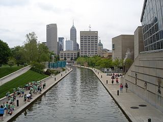
Marion County is located in the U.S. state of Indiana. The 2020 United States census reported a population of 977,203, making it the most populous county in the state and 51st most populated county in the country. Indianapolis is the county seat, the state capital, and most populous city. Marion County is consolidated with Indianapolis through an arrangement known as Unigov.

<span class="mw-page-title-main">Hendricks County, Indiana</span> County in Indiana, United States

Hendricks County is a county in the U.S. state of Indiana. As of the 2020 United States Census, the population was 174,788. The county seat is the town of Danville.

<span class="mw-page-title-main">Hamilton County, Indiana</span> County in Indiana, United States

Hamilton County is a county in the U.S. state of Indiana. The 2020 United States Census recorded a population of 347,467. The county seat is Noblesville.

<span class="mw-page-title-main">Lawrence, Indiana</span> City in Indiana, United States

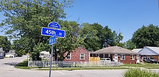
Lawrence is a city in Marion County, Indiana, United States. It is one of four "excluded cities" in Marion County. The city is home to Fort Benjamin Harrison within Fort Harrison State Park. The population was 49,370 at the 2020 census. The city is on the northeast side of Indianapolis.

<span class="mw-page-title-main">Crows Nest, Indiana</span> Town in Indiana, United States

Crows Nest is a town in Washington Township, Marion County, Indiana, United States, approximately 7 miles (11 km) north of downtown Indianapolis. The population was 67 at the 2020 census. It has existed as an "included town" since 1970, when it was incorporated into Indianapolis as part of Unigov. It is part of Indianapolis, but retains a functioning town government under IC 36-3-1-11.

<span class="mw-page-title-main">Perry Township, Marion County, Indiana</span> Township in Indiana, United States

Perry Township is one of the nine townships of Marion County, Indiana, United States, located in the south central part of the county. It was laid out in 1822 by the U.S. Army Corps of Engineers and named after Oliver Hazard Perry – a War of 1812 hero. The township population was 108,972 at the 2010 census. This includes the largest community of Burmese-Americans in the United States, numbering over 24,000. Through the White River, Perry and Decatur townships share the only water boundary among Marion County's townships.

West Newton, Indiana is a neighborhood located in southwestern Marion County. West Newton is situated ten miles (16.1 km) southwest of downtown Indianapolis in south central Decatur Township. It originated as a small Quaker-settled town. It has been incorporated into Indianapolis. The ZIP Code for West Newton is 46183.

<span class="mw-page-title-main">Damascus, Ohio</span> Census-designated place in Ohio, United States

Damascus is an unincorporated community and census-designated place in southern Mahoning and northern Columbiana counties in the U.S. state of Ohio. As of the 2020 census, it had a population of 418. The community lies at the intersection of U.S. Route 62 and State Routes 173 and 534.

<span class="mw-page-title-main">Marion Township, Owen County, Indiana</span> Township in Indiana, United States

Marion Township is one of thirteen townships in Owen County, Indiana, United States. As of the 2010 census, its population was 916 and it contained 464 housing units.

<span class="mw-page-title-main">Center Township, Marion County, Indiana</span> Township in Indiana, United States

Center Township is one of nine townships in Marion County, Indiana, in the United States. As of the 2010 census, its population was 142,787 and it contained 76,872 housing units. It is the most populated township in Marion County.

<span class="mw-page-title-main">Benton Township, Monroe County, Indiana</span> Township in Indiana, United States

Benton Township is one of eleven townships in Monroe County, Indiana, United States. As of the 2010 census, its population was 3,358 and it contained 1,716 housing units.

<span class="mw-page-title-main">Salt Creek Township, Decatur County, Indiana</span> Township in Indiana, United States

Salt Creek Township is one of nine townships in Decatur County, Indiana. As of the 2010 census, its population was 1,179 and it contained 483 housing units.

<span class="mw-page-title-main">Columbia Township, Jennings County, Indiana</span> Township in Indiana, United States

Columbia Township is one of eleven townships in Jennings County, Indiana, United States. As of the 2010 census, its population was 868 and it contained 411 housing units.

<span class="mw-page-title-main">Shepardsville, Indiana</span> Census-designated place in Indiana, United States

Shepardsville is an unincorporated census-designated place in northeastern Fayette Township, Vigo County, in the U.S. state of Indiana. It lies along Trinity Ave. north of the city of Terre Haute, the county seat of Vigo County. Its elevation is 502 feet (153 m), and it is located at 39°36′3″N87°25′3″W. Although Shepardsville is unincorporated, it has a post office, with the ZIP code of 47880.

<span class="mw-page-title-main">Patricksburg, Indiana</span> Unincorporated community in Indiana, United States

Patricksburg is an unincorporated community in eastern Marion Township, Owen County, in the U.S. state of Indiana. It lies along State Road 246, west of the city of Spencer, the county seat of Owen County. Its elevation is 715 feet (218 m), and it is located at 39°18′56″N86°57′33″W. Although Patricksburg is unincorporated, it has a post office, with the ZIP code of 47455.

<span class="mw-page-title-main">Fontanet, Indiana</span> Census-designated place in Indiana, United States

Fontanet is an unincorporated census-designated place in central Nevins Township, Vigo County, in the U.S. state of Indiana. It lies along Baldwin St., northeast of the city of Terre Haute, the county seat of Vigo County. Its elevation is 614 feet (187 m), and it is located at 39°34′34″N87°14′37″W. Although Fontanet is unincorporated, it has a post office, with the ZIP Code of 47851.

<span class="mw-page-title-main">Butlerville, Indiana</span> Census-designated place in Indiana, United States

Butlerville is an unincorporated community and census-designated place (CDP) in central Campbell Township, Jennings County, Indiana, United States. As of the 2010 census it had a population of 282.

<span class="mw-page-title-main">Homecroft, Indiana</span> Town in Indiana, United States

Homecroft is a town in Perry Township, Marion County, Indiana, United States. The population was 752 at the 2020 census. Incorporated in 1949, it has existed as an included town since 1970, when it was incorporated into Indianapolis as part of Unigov. It is part of Indianapolis, but retains a functioning town government under IC 36-3-1-11.

References

  1. "U.S. Census website". United States Census Bureau . Retrieved May 5, 2022.
  2. "US Board on Geographic Names". United States Geological Survey. October 25, 2007. Retrieved January 31, 2008.
  3. 1 2 "2020 Decennial Census". United States Census Bureau . Retrieved November 24, 2023.
  4. "Profile of General Population and Housing Characteristics: 2010 Demographic Profile Data (DP-1): Decatur township, Marion County, Indiana". United States Census Bureau . Retrieved February 13, 2012.
  5. Bodenhamer, David J.; Barrows, Robert G. (November 22, 1994). The Encyclopedia of Indianapolis. Indiana University Press. p. 495. ISBN   0-253-11249-4.
  6. "Decatur Township Civic Council". www.decaturtownship.org. Retrieved January 31, 2022.
  7. "MSD Decatur Twp Coronavirus Updates". www.decaturproud.org. Retrieved January 31, 2022.
  8. DeLorme. Indiana Atlas & Gazetteer. 3rd ed. Yarmouth: DeLorme, 2004, p. 44. ISBN   0-89933-319-2.
  9. Geographic Names Information System Feature Detail Report, Geographic Names Information System, 1979-02-14. Accessed 2008-06-01.
  10. Zip Code Lookup