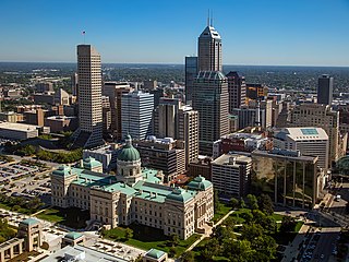
Indianapolis, colloquially known as Indy, is the capital and most populous city of the U.S. state of Indiana and the seat of Marion County. Located in Central Indiana, the city lies along the White River's West Fork near its confluence with Fall Creek.

Marion County is located in the U.S. state of Indiana. The 2020 United States census reported a population of 977,203, making it the most populous county in the state and 51st most populated county in the country. Indianapolis is the county seat, the state capital, and most populous city. Marion County is consolidated with Indianapolis through an arrangement known as Unigov. Marion County is the central county of the Indianapolis–Carmel–Anderson MSA in Central Indiana.

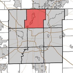
Meridian Hills is a town in Washington Township, Marion County, Indiana, about 8 miles (13 km) north of downtown Indianapolis. It had a population of 1,774 at the 2020 census, up from 1,616 in 2010.

North Crows Nest is a town in Washington Township, Marion County, Indiana, United States. It is approximately 7 miles (11 km) north of downtown Indianapolis. The population was 44 at the 2020 census. It has existed as an "included town" since 1970, when it was incorporated into Indianapolis as part of Unigov. It is part of Indianapolis, but retains town governmental powers under IC 36-3-1-11.
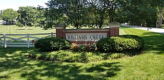
Williams Creek is a town in Washington Township, Marion County, Indiana, United States. It is located about 9 miles (14 km) north of downtown Indianapolis. The population was 430 at the 2020 census. It has existed as an "included town" since 1970, when it was incorporated into Indianapolis as part of Unigov. It is part of Indianapolis, but retains a functioning town government under IC 36-3-1-11.

Crows Nest is a town in Washington Township, Marion County, Indiana, United States, approximately 7 miles (11 km) north of downtown Indianapolis. The population was 67 at the 2020 census. It has existed as an "included town" since 1970, when it was incorporated into Indianapolis as part of Unigov. It is part of Indianapolis, but retains a functioning town government under IC 36-3-1-11.

Unigov is the colloquial name adopted by the city of Indianapolis, Indiana, to describe its consolidated city–county government. By an act of the Indiana General Assembly, Indianapolis consolidated with the government of Marion County in 1970.

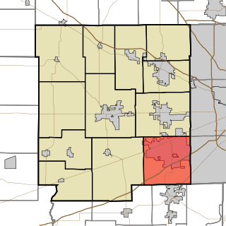
The Indianapolis metropolitan area is an 11-county metropolitan area in the U.S. state of Indiana. Its principal cities are Indianapolis, Carmel, Greenwood, and Anderson. Other primary cities with populations of more than 50,000 include Fishers, Noblesville, and Westfield. Located in Central Indiana, it is the largest metropolitan area entirely within Indiana and the seventh largest in the American Midwest.

Perry Township is one of the nine townships of Marion County, Indiana, United States, located in the south central part of the county. It was laid out in 1822 by the U.S. Army Corps of Engineers and named after Oliver Hazard Perry – a War of 1812 hero. The township population was 121,768 at the 2020 census, up from 108,972 at 2010. This includes the largest community of Burmese-Americans in the United States, numbering over 24,000. Through the White River, Perry and Decatur townships share the only water boundary among Marion County's townships.

Decatur Township is one of the nine townships in Marion County, Indiana, United States, and part of the consolidated city of Indianapolis. As of the 2020 census, it had a population of 36,951. Located in the southwest corner of the county, the township is home to the Indianapolis International Airport main terminal. It is one of the most rural sections of the county, but has seen many new residential and commercial developments. AmeriPlex, one of the largest industrial parks in Indiana, is in Decatur Township. Through the White River, Decatur and Perry townships share the only water boundary among Marion County's townships.

Pike Township is one of the nine townships of Marion County, Indiana, United States, North America, located in the northwestern portion of the county. The entire township is administratively part of Indianapolis, although a portion of the included town of Clermont lies in the southwest corner. As of the 2020 census, Pike Township had a population of 83,030 living in an area of approximately 107 km² (41.5 mi²). Pike Township was named for Zebulon Pike.
Guilford Township is one of twelve townships in Hendricks County, Indiana, United States. As of the 2010 census, its population was 27,844.

Washington Township is one of twelve townships in Hendricks County, Indiana, United States. As of the 2010 census, its population was 44,764.

Kirklin Township is one of fourteen townships in Clinton County, Indiana. As of the 2020 census, its population was 1,219 and it contained 544 housing units.

Sugar Creek Township is one of fourteen townships in Clinton County, Indiana. As of the 2020 census, its population was 456 and it contained 207 housing units. The township is named for the stream that flows southwest through it.

Delaware Township is one of nine townships in Hamilton County, Indiana, United States. As of the 2010 census, its population was 30,617 and it contained 13,553 housing units. Records show the township to have had 43,352 residents in 2007.

Center Township is one of thirteen townships in Grant County, Indiana, United States. As of the 2010 census, its population was 23,406 and it contained 10,189 housing units. It is home to the Veterans Administration Medical Center.

Buck Creek Township is one of nine townships in Hancock County, Indiana, United States. As of the 2010 census, its population was 8,430 and it contained 3,158 housing units.
Indianapolis (balance) is a statistical entity defined by the United States Census Bureau to represent the portion of the city of Indianapolis, Indiana, that is not within the "included towns". As of the 2020 census the balance had a total population of 887,642.