Southport, Indiana

Last updated

Southport, Indiana
Eastbound Southport Road.jpg
Bethel Community Church and Southport Farmers Market
Marion County Indiana Incorporated and Unincorporated areas Southport Highlighted 1871486.svg
Location in Marion County, Indiana
Coordinates: 39°39′41″N86°07′18″W / 39.66139°N 86.12167°W / 39.66139; -86.12167
Country United States
State Indiana
County Marion
Government
  Type City Council
   Mayor James Cooney (R)[ citation needed ]
Area
[1]
  Total0.63 sq mi (1.63 km2)
  Land0.63 sq mi (1.63 km2)
  Water0.00 sq mi (0.00 km2)  0%
Elevation
[2]
781 ft (238 m)
Population
 (2020) [3]
  Total2,123
  Density3,380.57/sq mi (1,306.09/km2)
Time zone UTC-5 (EST)
  Summer (DST) UTC-4 (EDT)
ZIP code
46227
Area code 317
FIPS code 18-71486 [4]
GNIS feature ID2395920 [2]
Website southport.in.gov
Welcome sign Welcome to Southport.jpg
Welcome sign

Southport is an excluded city in Marion County, Indiana, United States. The population was 2,123 at the 2020 census, [3] up from 1,712 in 2010.

Contents

History

The area that is now known as Southport was a wooded area until the first European American settlers arrived in the 1820s. [5] Early settlers included Jacob Smock and Randall Litzey in 1822, Samuel Brewer in 1823, Benjamin McFarland in 1826, and Samuel and Mary Bryan in 1828. [5] Mary Bryan is remembered as one of the first European American women to cross the Cumberland Mountains. [6] By 1828 Southport was a stagecoach stop on the Madison–Indianapolis road. [5] Southport claims it was founded in 1832. [5] The town was platted in 1852. [7]

In 1847 the Jeffersonville, Madison and Indianapolis Railroad was opened through Southport, increasing traffic to and through the town, and bringing increased development. [5] By 1884 the population had reached 388. [5] By 1960 it was 892. [5] Southport contained a post office until 1960. [8]

Geography

Southport is located in southern Marion County. It is bordered to the north by the town of Homecroft. Downtown Indianapolis is 8 miles (13 km) to the north.

According to the U.S. Census Bureau, Southport has a total area of 0.63 square miles (1.63 km2), all land. [1] Little Buck Creek passes through the northern part of town, flowing generally west to the White River.

Demographics

Historical population
CensusPop.Note
1880 388
1890 324−16.5%
1900 285−12.0%
1910 35223.5%
1920 45830.1%
1930 52113.8%
1940 5495.4%
1950 73033.0%
1960 89222.2%
1970 2,342162.6%
1980 2,266−3.2%
1990 1,969−13.1%
2000 1,852−5.9%
2010 1,712−7.6%
2020 2,12324.0%
U.S. Decennial Census [9]

2010 census

As of the census [10] of 2010, there were 1,712 people, 696 households, and 484 families living in the city. The population density was 2,717.5 inhabitants per square mile (1,049.2/km2). There were 763 housing units at an average density of 1,211.1 per square mile (467.6/km2). The racial makeup of the city was 94.1% White, 1.8% African American, 0.1% Native American, 1.1% Asian, 1.8% from other races, and 1.2% from two or more races. Hispanic or Latino of any race were 3.4% of the population.

There were 696 households, of which 30.0% had children under the age of 18 living with them, 51.3% were married couples living together, 12.9% had a female householder with no husband present, 5.3% had a male householder with no wife present, and 30.5% were non-families. 24.0% of all households were made up of individuals, and 10.4% had someone living alone who was 65 years of age or older. The average household size was 2.46 and the average family size was 2.89.

The median age in the city was 41.3 years. 22.1% of residents were under the age of 18; 7.8% were between the ages of 18 and 24; 24.4% were from 25 to 44; 29.9% were from 45 to 64; and 15.7% were 65 years of age or older. The gender makeup of the city was 48.1% male and 51.9% female.

2000 census

As of the census [4] of 2000, there were 1,852 people, 733 households, and 521 families living in the city. The population density was 2,886.2 inhabitants per square mile (1,114.4/km2). There were 769 housing units at an average density of 1,198.4 per square mile (462.7/km2). The racial makeup of the city was 96.54% White, 0.38% African American, 0.11% Native American, 0.86% Asian, 1.30% from other races, and 0.81% from two or more races. Hispanic or Latino of any race were 2.38% of the population.

There were 733 households, out of which 32.3% had children under the age of 18 living with them, 56.9% were married couples living together, 10.2% had a female householder with no husband present, and 28.8% were non-families. 23.9% of all households were made up of individuals, and 8.0% had someone living alone who was 65 years of age or older. The average household size was 2.53 and the average family size was 2.97.

In the city, the population was spread out, with 24.4% under the age of 18, 7.4% from 18 to 24, 29.8% from 25 to 44, 26.0% from 45 to 64, and 12.4% who were 65 years of age or older. The median age was 39 years. For every 100 females, there were 97.0 males. For every 100 females age 18 and over, there were 94.7 males.

The median income for a household in the city was $56,719, and the median income for a family was $59,926. Males had a median income of $48,295 versus $28,125 for females. The per capita income for the city was $24,374. About 4.3% of families and 6.2% of the population were below the poverty line, including 7.2% of those under age 18 and 3.6% of those age 65 or over.

Education

Southport is in the Metropolitan School District of Perry Township, whose Southport Elementary is within the city boundaries. The Southport branch of the Indianapolis Public Library, while not actually in Southport, lies immediately west of the city's boundary on Stop 11 Road. [11]

See also

Related Research Articles

<span class="mw-page-title-main">Alexandria, Indiana</span> City in Indiana, United States

Alexandria is a city in Monroe Township, Madison County, Indiana, United States. It is about 48 miles (77 km) northeast of Indianapolis. According to the 2020 census, its population was 5,149, nearly unchanged from 2010.

<span class="mw-page-title-main">Jamestown, Indiana</span> Town in Indiana, United States

Jamestown is a town in Jackson Township, Boone County and Eel River Township, Hendricks County, Indiana, United States. The population was 958 at the 2010 census.

<span class="mw-page-title-main">Ulen, Indiana</span> Town in Indiana, United States

Ulen is a town in Center Township, Boone County, in the U.S. state of Indiana. The population was 117 at the 2010 census. The town is surrounded by the city of Lebanon.

<span class="mw-page-title-main">Michigantown, Indiana</span> Town in Indiana, United States

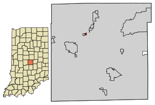
Michigantown is a town in Michigan Township, Clinton County, Indiana, United States. The population was 467 at the 2010 census. The town was named for the Michigan Road, an early thoroughfare through the area.

<span class="mw-page-title-main">Wilkinson, Indiana</span> Town in Indiana, United States

Wilkinson is a town in Brown Township, Hancock County, Indiana, United States. The population was 449 at the 2010 census.

<span class="mw-page-title-main">Whiteland, Indiana</span> Town in Indiana, United States

Whiteland is a town in Pleasant, Franklin and Clark townships, Johnson County, Indiana, United States. The population was 4,599 at the 2020 census.

<span class="mw-page-title-main">Edgewood, Indiana</span> Town in Indiana, United States

Edgewood is a town in Anderson Township, Madison County, Indiana, United States. It is part of the Indianapolis–Carmel–Anderson metropolitan statistical area. The population was 2,053 at the 2020 census.

<span class="mw-page-title-main">Ingalls, Indiana</span> Town in Indiana, United States

Ingalls is a town in Green Township, Madison County, Indiana, United States. It is part of the Indianapolis–Carmel–Anderson metropolitan statistical area. The population was 2,223 at the 2020 census.

<span class="mw-page-title-main">River Forest, Indiana</span> Town in Indiana, United States

River Forest is a town in Anderson Township, Madison County, Indiana, United States. It is part of the Indianapolis–Carmel–Anderson metropolitan statistical area. The population was 26 at the 2020 census.

<span class="mw-page-title-main">Woodlawn Heights, Indiana</span> Town in Indiana, United States

Woodlawn Heights is a town in Anderson Township, Madison County, Indiana, United States. It is part of the Indianapolis–Carmel–Anderson metropolitan statistical area. The population was 91 at the 2020 census.

<span class="mw-page-title-main">Lawrence, Indiana</span> City in Indiana, United States

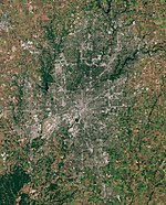
Lawrence is a city in Marion County, Indiana, United States. It is one of four "excluded cities" in Marion County. The city is home to Fort Benjamin Harrison within Fort Harrison State Park. The population was 49,370 at the 2020 census. The city is on the northeast side of Indianapolis.

<span class="mw-page-title-main">Bethany, Indiana</span> Town in Indiana, United States

Bethany is a town in Clay Township, Morgan County, in the U.S. state of Indiana. The population was 95 at the 2020 census.

<span class="mw-page-title-main">Russellville, Indiana</span> Town in Indiana, United States

Russellville is a town in Russell Township, Putnam County, in the U.S. state of Indiana. The population was 358 at the 2010 census.

<span class="mw-page-title-main">Meridian Hills, Indiana</span> Town in Indiana, United States

Meridian Hills is a town in Washington Township, Marion County, Indiana, about 8 miles (13 km) north of downtown Indianapolis. It had a population of 1,774 at the 2020 census, up from 1,616 in 2010.

<span class="mw-page-title-main">Rocky Ripple, Indiana</span> Town in Indiana, United States

Rocky Ripple is a town in Marion County, Indiana, United States. The population was 655 at the 2020 census. It was founded in 1927, and the town was incorporated as an "included town" as part of Unigov in 1970. It is part of Indianapolis, but retains a separate functioning town government under IC 36-3-1-11. Although not far from the city center, Rocky Ripple is a somewhat isolated area, located between the Central Canal and the White River; only two traffic-supporting bridges over the canal provide access to the town.

<span class="mw-page-title-main">Spring Hill, Indiana</span> Town in Indiana, United States

Spring Hill is a town in Marion County, Indiana, United States. The population was 95 at the 2020 census. It has existed as an "included town" since 1970, when it was incorporated into Indianapolis as part of Unigov. It is part of Indianapolis, but retains town governmental powers under IC 36-3-1-11.

<span class="mw-page-title-main">Williams Creek, Indiana</span> Town in Indiana, United States

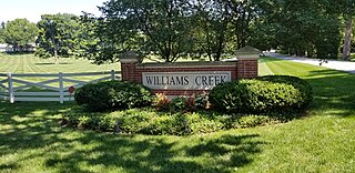
Williams Creek is a town in Washington Township, Marion County, Indiana, United States. It is located about 9 miles (14 km) north of downtown Indianapolis. The population was 430 at the 2020 census. It has existed as an "included town" since 1970, when it was incorporated into Indianapolis as part of Unigov. It is part of Indianapolis, but retains a functioning town government under IC 36-3-1-11.

<span class="mw-page-title-main">Wynnedale, Indiana</span> Town in Indiana, United States

Wynnedale is a town in Washington Township, Marion County, Indiana, United States. The population was 215 at the 2020 census. It has existed as an "included town" since 1970, when it was incorporated into Indianapolis as part of Unigov. It is part of Indianapolis, but retains a functioning town government under IC 36-3-1-11.

<span class="mw-page-title-main">Homecroft, Indiana</span> Town in Indiana, United States

Homecroft is a town in Perry Township, Marion County, Indiana, United States. The population was 752 at the 2020 census. Incorporated in 1949, it has existed as an included town since 1970, when it was incorporated into Indianapolis as part of Unigov. It is part of Indianapolis, but retains a functioning town government under IC 36-3-1-11.

Indianapolis (balance) is a statistical entity defined by the United States Census Bureau to represent the portion of the city of Indianapolis, Indiana, that is not within the "included towns". As of the 2020 census the balance had a total population of 887,642.

References

  1. 1 2 "2022 U.S. Gazetteer Files: Indiana". United States Census Bureau. Retrieved April 13, 2023.
  2. 1 2 U.S. Geological Survey Geographic Names Information System: Southport, Indiana
  3. 1 2 "P1. Race – Southport city, Indiana: 2020 DEC Redistricting Data (PL 94-171)". U.S. Census Bureau. Retrieved April 13, 2023.
  4. 1 2 "U.S. Census website". United States Census Bureau . Retrieved January 31, 2008.
  5. 1 2 3 4 5 6 7 Browning, Barry (November 21, 2019). "Remembering Southport history". Southside Times. Retrieved August 3, 2020.
  6. Indiana Historical Marker Program (1975). Mary Bryan, Pioneer Woman (Indiana Historical Marker). Southport, IN: Indiana Department of Natural Resources. Retrieved August 3, 2020.
  7. Baker, Ronald L. (October 1995). From Needmore to Prosperity: Hoosier Place Names in Folklore and History . Indiana University Press. p.  306. ISBN   978-0-253-32866-3. This city was platted on April 5, 1852.
  8. "Marion County". Jim Forte Postal History. Retrieved January 18, 2015.
  9. "Census of Population and Housing". Census.gov. Retrieved June 4, 2015.
  10. "U.S. Census website". United States Census Bureau . Retrieved December 11, 2012.
  11. "Locations & Hours". Indianapolis Public Library. Retrieved March 10, 2018.