Deerfield, New Hampshire

Last updated

Deerfield, New Hampshire
DeerfieldNH Library.jpg
Soldier's Memorial and Library
Deerfield Town Seal.png
Rockingham County New Hampshire incorporated and unincorporated areas Deerfield highlighted.svg
Location in Rockingham County and the state of New Hampshire.
Coordinates: 43°08′46″N71°12′59″W / 43.14611°N 71.21639°W / 43.14611; -71.21639
Country United States
State New Hampshire
County Rockingham
Incorporated 1766
Villages
  • Deerfield
  • Deerfield Center
  • Deerfield Parade
  • South Deerfield
Government
   Board of Selectmen
  • Richard W. Pitman, Chair
  • Frederick J. McGarry
  • Cindy McHugh
  • Steve Barry
  • William Huebner
  Town AdministratorJohn Harrington Jr.
Area
[1]
  Total52.10 sq mi (134.93 km2)
  Land50.76 sq mi (131.46 km2)
  Water1.34 sq mi (3.47 km2)  2.57%
Elevation
515 ft (157 m)
Population
 (2020) [2]
  Total4,855
  Density96/sq mi (36.9/km2)
Time zone UTC-5 (Eastern)
  Summer (DST) UTC-4 (Eastern)
ZIP code
03037
Area code 603
FIPS code 33-17460
GNIS feature ID0873576
Website www.townofdeerfieldnh.com

Deerfield is a town in Rockingham County, New Hampshire, United States. The population was 4,855 at the 2020 census, [2] up from 4,280 in 2010. Deerfield is the location of the annual Deerfield Fair.

Contents

History

Deerfield was originally part of Nottingham. In 1756, residents petitioned for organization of a separate parish, but were denied. In 1765, while a second petition was pending, two local hunters presented colonial governor Benning Wentworth with a deer. Permission was granted, and "Deerfield" was incorporated in 1766. The incorporation act for Deerfield was signed by three members of the Leavitt family, including Capt. Samuel Leavitt who later was one of the town's first selectmen. Leavitts Hill in Deerfield was named for the family, who had first settled in nearby Exeter. [3]

"Deerfield Parade", a hilltop district first settled circa 1740, was located on the early postal route between Concord and Portsmouth. Here, the militia of the Revolutionary and Civil wars trained and "paraded" on the village common. The "Parade" was then a professional, cultural and trade center. About 1798, citizens founded Deerfield Academy, a high school. It burned in 1842.

Once a thriving farm community which was disappointed when bypassed by railroads, the town in 1876 established the Deerfield Fair. Now billed as "New England's Oldest Family Fair", the four-day event draws huge crowds each autumn to admire animals, produce and crafts, or to enjoy amusement park rides.

Geography

According to the United States Census Bureau, the town has a total area of 52.1 square miles (134.9 km2), of which 50.8 square miles (131.5 km2) are land and 1.4 square miles (3.5 km2) are water, comprising 2.57% of the town. [1] The highest point in Deerfield as well as in Rockingham County is the summit of Nottingham Mountain, at 1,345 feet (410 m) above sea level, near the town's western border. Portions of the Pawtuckaway Mountains occupy the eastern border of the town. Deerfield is primarily drained by the Lamprey River and its tributary the North Branch River, within the Piscataqua River (Coastal) watershed, while the western edge and northernmost section of town is in the Merrimack River watershed. [4]

Adjacent municipalities

Demographics

Historical population
CensusPop.Note
1790 1,619
1800 1,87816.0%
1810 1,851−1.4%
1820 2,13315.2%
1830 2,086−2.2%
1840 1,953−6.4%
1850 2,0223.5%
1860 2,0662.2%
1870 1,768−14.4%
1880 1,569−11.3%
1890 1,220−22.2%
1900 1,162−4.8%
1910 917−21.1%
1920 746−18.6%
1930 635−14.9%
1940 74918.0%
1950 706−5.7%
1960 7141.1%
1970 1,17865.0%
1980 1,97968.0%
1990 3,12457.9%
2000 3,67817.7%
2010 4,28016.4%
2020 4,85513.4%
U.S. Decennial Census [2] [5]
Deerfield Community Church, near the town center DeerfieldNH CenterChurch.jpg
Deerfield Community Church, near the town center

At the 2000 census, [6] there were 3,678 people, 1,225 households and 986 families residing in the town. The population density was 72.2 per square mile (27.9/km2). There were 1,406 housing units at an average density of 27.6 per square mile (10.7/km2). The racial make-up was 98.53% White, 0.16% African American, 0.14% Native American, 0.14% Asian, 0.22% from other races and 0.82% from two or more races. Hispanic or Latino of any race were 0.30% of the population.

There were 1,225 households, of which 43.3% had children under the age of 18 living with them, 71.0% were married couples living together, 5.3% had a female householder with no husband present, and 19.5% were non-families. 12.9% of all households were made up of individuals, and 3.8% had someone living alone who was 65 years of age or older. The average household size was 2.98 and the average family size was 3.27.

Age distribution was 30.0% under the age of 18, 5.2% from 18 to 24, 33.0% from 25 to 44, 24.9% from 45 to 64, and 6.9% who were 65 years of age or older. The median age was 36 years. For every 100 females, there were 95.8 males. For every 100 females age 18 and over, there were 97.1 males.

The median household income was $61,367 and the median family income was $64,737. Males had a median income of $40,568 and females $30,682. The per capita income was $24,160. About 1.3% of families and 3.2% of the population were below the poverty line, including 1.0% of those under age 18 and 10.4% of those age 65 or over.

Transportation

Two New Hampshire state routes cross Deerfield.

Education

There is one public school in Deerfield, the Deerfield Community School on North Road, which serves students in grades Pre-K–8. The current[ when? ] principal is Kristen Withee. Deerfield Community School was opened in 1990 and replaced the George B. White School. The George B. White Building is now commercial space and houses, among other things, the town offices and the police department. Deerfield students have attended various local high schools over the years, as there is no high school in the town. Starting with the DCS graduating class of 1995, the town has sent students graduating from Deerfield Community School to Concord High School. Other options have included Coe-Brown Northwood Academy in Northwood, Central High School in Manchester, West High School in Manchester, Pembroke Academy in Pembroke, and Oyster River High School in Durham. The students graduating from Deerfield community school still continue to go to Concord high unless given opportunities to go to other schools.

Notable organizations

Notable people

See also

Related Research Articles

<span class="mw-page-title-main">Rockingham County, New Hampshire</span> County in New Hampshire, United States

Rockingham County is a county in the U.S. state of New Hampshire. As of the 2020 census, the population was 314,176, making it New Hampshire's second-most populous county. The county seat is Brentwood. Rockingham County is part of the Boston-Cambridge-Newton, MA-NH Metropolitan Statistical Area and the greater Boston-Worcester-Providence, MA-RI-NH-CT Combined Statistical Area. Per the 2020 census, it was New Hampshire's fastest growing county from 2010 to 2020.

<span class="mw-page-title-main">Allenstown, New Hampshire</span> Town in New Hampshire, United States

Allenstown is a town in Merrimack County, New Hampshire, United States. The population was 4,707 at the 2020 census, up from 4,322 at the 2010 census. Allenstown includes a portion of the village of Suncook. Just over one-half of the town's area is covered by Bear Brook State Park.

<span class="mw-page-title-main">Epsom, New Hampshire</span> Town in New Hampshire, United States

Epsom is a town in Merrimack County, New Hampshire, United States. The population was 4,834 at the 2020 census.

<span class="mw-page-title-main">Pembroke, New Hampshire</span> Town in New Hampshire, United States

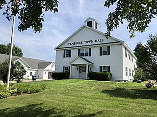
Pembroke is a town in Merrimack County, New Hampshire, United States. The population was 7,207 at the 2020 census. Pembroke includes part of the village of Suncook. The center of population of New Hampshire is close to the Pembroke town center.

<span class="mw-page-title-main">Auburn, New Hampshire</span> Place in New Hampshire, United States

Auburn is a town in Rockingham County, New Hampshire, United States. The population was 5,946 at the 2020 census, up from 4,953 at the 2010 census.

<span class="mw-page-title-main">Candia, New Hampshire</span> Place in New Hampshire, United States

Candia is a town in Rockingham County, New Hampshire, United States. The population was 4,013 at the 2020 census. The town includes the villages of Candia, Candia Four Corners and East Candia.

<span class="mw-page-title-main">Chester, New Hampshire</span> Town in New Hampshire, United States

Chester is a town in Rockingham County, New Hampshire, United States. The population was 5,232 at the 2020 census, up from 4,768 at the 2010 census. It was home to the now defunct Chester College.

<span class="mw-page-title-main">Hampstead, New Hampshire</span> Place in New Hampshire, United States

Hampstead is a town in Rockingham County, New Hampshire, United States. The population was 8,998 at the 2020 census. Hampstead, which includes the village of East Hampstead, is home to a portion of the Rockingham Recreational Trail.

<span class="mw-page-title-main">Newfields, New Hampshire</span> Place in New Hampshire, United States

Newfields is a town in Rockingham County, New Hampshire, United States. The population was 1,769 at the 2020 census. The primary village in town, where 378 people resided at the 2020 census, is defined as the Newfields census-designated place (CDP) and is located along New Hampshire Route 85 and the Squamscott River. It is a quaint village of handsome old houses.

<span class="mw-page-title-main">Northwood, New Hampshire</span> Place in New Hampshire, United States

Northwood is a town in Rockingham County, New Hampshire, United States. The population was 4,641 at the 2020 census.

<span class="mw-page-title-main">Nottingham, New Hampshire</span> Town in New Hampshire, United States

Nottingham is a town in Rockingham County, New Hampshire, United States. The population was 5,229 at the 2020 census, up from 4,785 at the 2010 census. It is the location of Pawtuckaway State Park.

<span class="mw-page-title-main">South Hampton, New Hampshire</span> Town in New Hampshire, United States

South Hampton is a town in Rockingham County, New Hampshire, United States. The population was 894 at the 2020 census. South Hampton is home to Cowden State Forest and Powwow River State Forest.

<span class="mw-page-title-main">Concord, Vermont</span> Town in Vermont, United States

Concord is a town in Essex County, Vermont, United States. The population was 1,141 at the 2020 census. It is part of the Berlin, NH–VT Micropolitan Statistical Area.

<span class="mw-page-title-main">Hooksett, New Hampshire</span> Town in New Hampshire, United States

Hooksett is a town in Merrimack County, New Hampshire, United States. The population was 14,871 at the 2020 census, up from 13,451 at the 2010 census. The town is located between Manchester, the state's largest city, and Concord, the state capital. A prominent landmark is Robie's Country Store, a National Historic Landmark and a frequent stop for presidential candidates during the New Hampshire primary.

<span class="mw-page-title-main">Epping, New Hampshire</span> Place in New Hampshire, United States

Epping is a town in Rockingham County, New Hampshire, United States. The population was 7,125 at the 2020 census, up from 6,411 at the 2010 census.

<span class="mw-page-title-main">Hampton, New Hampshire</span> Place in New Hampshire, United States

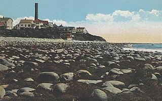
Hampton is a town in Rockingham County, New Hampshire, United States. The population was 16,214 at the 2020 census. On the Atlantic coast, Hampton is home to Hampton Beach, a summer tourist destination.

<span class="mw-page-title-main">Raymond (CDP), New Hampshire</span> Census-designated place in New Hampshire, United States

Raymond is a census-designated place (CDP) and the main village in the town of Raymond, Rockingham County, New Hampshire, United States. The population of the CDP was 3,738 at the 2020 census, out of 10,684 in the entire town.

<span class="mw-page-title-main">Raymond, New Hampshire</span> Place in New Hampshire, United States

Raymond is a town in Rockingham County, New Hampshire, United States. The population was 10,684 at the 2020 census. Part of Pawtuckaway State Park is in the north.

<span class="mw-page-title-main">New Hampshire Route 43</span> State highway in Rockingham County, New Hampshire, US

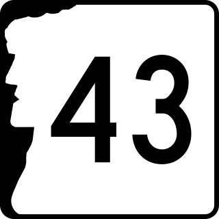
New Hampshire Route 43 is a 16.418-mile-long (26.422 km) north–south state highway in southeastern New Hampshire which runs from Candia to Northwood. The southern terminus of NH 43 is at an interchange with New Hampshire Route 101 in Candia. The northern terminus is at an intersection with U.S. Route 4, U.S. Route 202 and New Hampshire Route 9 in Northwood.

<span class="mw-page-title-main">New Hampshire Route 107</span> State highway in eastern New Hampshire, US

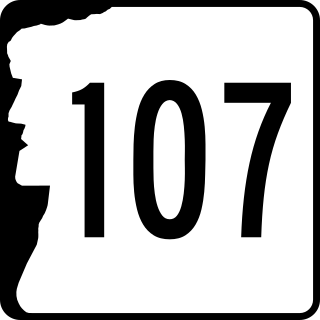
New Hampshire Route 107 is a 69.108-mile-long (111.219 km) north–south state highway in eastern New Hampshire. It connects Laconia in the Lakes Region with Seabrook on the Atlantic coast. The southern terminus of NH 107 is at U.S. Route 1 in Seabrook near the entrance to Seabrook Station Nuclear Power Plant. The northern terminus is at U.S. Route 3 on the Laconia/Gilford town line.

References

  1. 1 2 "2021 U.S. Gazetteer Files – New Hampshire". United States Census Bureau. Retrieved December 20, 2021.
  2. 1 2 3 "Deerfield town, Rockingham County, New Hampshire: 2020 DEC Redistricting Data (PL 94-171)". U.S. Census Bureau. Retrieved December 20, 2021.
  3. "History of Deerfield, History of Rockingham and Strafford Counties", D. Hamilton Hurd, 1882 [ permanent dead link ]
    - Genealogical and Family History of the State of New Hampshire, Ezra Scollay Stearns, 1908
  4. Foster, Debra H.; Batorfalvy, Tatianna N.; Medalie, Laura (1995). Water Use in New Hampshire: An Activities Guide for Teachers. U.S. Department of the Interior and U.S. Geological Survey.
  5. "Census of Population and Housing". Census.gov. Retrieved June 4, 2016.
  6. "U.S. Census website". United States Census Bureau . Retrieved January 31, 2008.
  7. "BUTLER, Benjamin Franklin, (1818 - 1893)". Biographical Directory of the United States Congress. Retrieved November 20, 2013.
  8. "Term: Harvey, Lorenzo Dow 1848 - 1922". Wisconsin Historical Society. Archived from the original on July 21, 2006. Retrieved November 19, 2013.