Drexel, Ohio

Last updated
Drexel, Ohio
CDP
Montgomery County Ohio incorporated and unincorporated areas Drexel highlighted.svg
Location in Montgomery County and the state of Ohio.
Coordinates: 39°44′26″N84°17′24″W / 39.74056°N 84.29000°W / 39.74056; -84.29000
Country United States
State Ohio
County Montgomery
Area
[1]
  Total2.18 sq mi (5.66 km2)
  Land2.18 sq mi (5.66 km2)
  Water0.00 sq mi (0.00 km2)
Elevation
[2]
951 ft (290 m)
Population
 (2020)
  Total1,693
  Density775.18/sq mi (299.26/km2)
Time zone UTC-5 (Eastern (EST))
  Summer (DST) UTC-4 (EDT)
ZIP code
45417
Area code(s) 937, 326
FIPS code 39-22624 [3]
GNIS feature ID2393399 [4]

Drexel is a census-designated place (CDP) in Jefferson Township, Montgomery County, Ohio, United States. The population was 1,693 at the 2020 census.

Contents

Geography

According to the United States Census Bureau, the CDP has a total area of 2.2 square miles (5.7 km2), all land.

Demographics

Historical population
CensusPop.Note
2020 1,693
U.S. Decennial Census [5]

Drexel is part of the Dayton Metropolitan Statistical Area.

As of the census [3] of 2000, there were 2,057 people, 773 households, and 535 families residing in the CDP. The population density was 943.5 inhabitants per square mile (364.3/km2). There were 864 housing units at an average density of 396.3 per square mile (153.0/km2). The racial makeup of the CDP was 61.69% White, 35.05% African American, 0.34% Native American, 0.15% Asian, 0.19% Pacific Islander, 0.24% from other races, and 2.33% from two or more races. Hispanic or Latino of any race were 0.68% of the population.

There were 773 households, out of which 35.3% had children under the age of 18 living with them, 36.2% were married couples living together, 26.1% had a female householder with no husband present, and 30.7% were non-families. 25.1% of all households were made up of individuals, and 10.2% had someone living alone who was 65 years of age or older. The average household size was 2.62 and the average family size was 3.11.

In the CDP the population was spread out, with 31.4% under the age of 18, 9.8% from 18 to 24, 26.3% from 25 to 44, 21.7% from 45 to 64, and 10.7% who were 65 years of age or older. The median age was 32 years. For every 100 females there were 91.2 males. For every 100 females ages 18 and over, there were 84.7 males.

The median income for a household in the CDP was $20,785, and the median income for a family was $21,061. Males had a median income of $28,804 versus $20,952 for females. The per capita income for the CDP was $10,257. About 33.5% of families and 31.5% of the population were below the poverty line, including 38.6% of those under age 18 and 14.1% of those ages 65 or over.

Related Research Articles

<span class="mw-page-title-main">Rock Creek, Alabama</span> CDP in Alabama, United States

Rock Creek is a census-designated place in Jefferson County, Alabama, United States. Its location is northwest of Hueytown. At the 2020 census, the population was 1,471. This area was damaged by an F5 tornado on April 8, 1998. An EF2 tornado struck northwest from here on January 23, 2012.

<span class="mw-page-title-main">Moores Mill, Alabama</span> Census-designated place in Alabama, United States

Moores Mill is an unincorporated community and census-designated place (CDP) in Madison County, Alabama, United States, and is included in the Huntsville-Decatur Combined Statistical Area. The population was 6,729 at the 2020 census, up from 5,682 at the 2010 census.

<span class="mw-page-title-main">Drexel-Alvernon, Arizona</span> CDP in Pima County, Arizona

Drexel-Alvernon was a census-designated place (CDP) in Pima County, Arizona, United States. The population was 4,192 at the 2000 census.

<span class="mw-page-title-main">Littletown, Arizona</span> CDP in Pima County, Arizona

Littletown was a census-designated place (CDP) in Pima County, Arizona, United States. The population was 1,010 at the 2000 census. The area was annexed into Tucson in 2017.

<span class="mw-page-title-main">Bayview-Montalvin, California</span> Former CDP in California, United States

Bayview-Montalvin is a former census-designated place (CDP) in Contra Costa County, California, United States. The population was 5,004 at the 2000 census.

<span class="mw-page-title-main">Riverdale, California</span> Census-designated place in California, United States

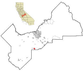
Riverdale is a census-designated place (CDP) in Fresno County, California, United States. The population was 3,153 at the 2010 census, up from 2,416 at the 2000 census. Riverdale is located 23 miles (37 km) south of Fresno, at an elevation of 223 ft (68 m).

<span class="mw-page-title-main">Humboldt Hill, California</span> Census-designated place in Humboldt County, California, U.S.

Humboldt Hill is a census-designated place (CDP) in Humboldt County, California, United States. Humboldt Hill rises to an elevation of 636 feet (194 m). The population was 3,414 at the 2010 census, up from 3,246 at the 2000 census. The area is in the 95503 zip code and part of unincorporated Eureka.

<span class="mw-page-title-main">Heber, California</span> American census-designated place

Heber is a census-designated place (CDP) in Imperial County, California. Heber is located 4.5 miles (7 km) north-northwest of Calexico. The population was 4,275 at the 2010 census, up from 2,566 in 2000.

<span class="mw-page-title-main">Terra Bella, California</span> Census-designated place in California, United States

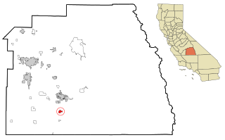
Terra Bella is a census-designated place (CDP) in Tulare County, California, United States. The population was 2,910 at the 2020 census, down from 3,310 at the 2010 census.

<span class="mw-page-title-main">Naval Academy, Maryland</span> Census-designated place in Maryland, United States

Naval Academy is a census-designated place (CDP) in Anne Arundel County, Maryland, United States, which covers the campus of the United States Naval Academy. The population was 4,802 at the 2010 census.

<span class="mw-page-title-main">Dunkirk, Maryland</span> Census-designated place in Maryland, United States

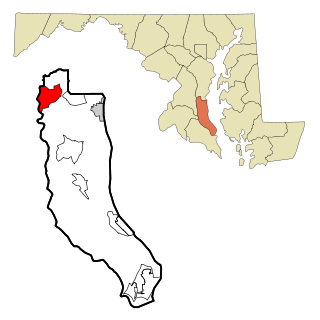
Dunkirk is a census-designated place (CDP) in Calvert County, Maryland, United States. The population was 2,521 at the 2010 census.

<span class="mw-page-title-main">Fairfield Harbour, North Carolina</span> Census-designated place in North Carolina, United States

Fairfield Harbour is an unincorporated community and census-designated place (CDP) in Craven County, North Carolina, United States. The population was 2,952 at the 2010 census, up from 1,983 in 2000. It is part of the New Bern, North Carolina Metropolitan Statistical Area.

<span class="mw-page-title-main">Northgate, Ohio</span> Census-designated place in Ohio, United States

Northgate is a census-designated place (CDP) in Colerain Township, Hamilton County, Ohio, United States. The population was 7,277 at the 2020 census.

<span class="mw-page-title-main">Kreamer, Pennsylvania</span> CDP in Pennsylvania, United States

Kreamer is a census-designated place (CDP) in Middlecreek Township, Snyder County, Pennsylvania, United States. The population was 773 at the 2000 census.

<span class="mw-page-title-main">Mayo, South Carolina</span> CDP in South Carolina, United States

Mayo is a census-designated place (CDP) in Spartanburg County, South Carolina, United States. The population was 1,592 at the 2010 census.

<span class="mw-page-title-main">Green Valley, South Dakota</span> CDP in South Dakota, United States

Green Valley is a census-designated place (CDP) and unincorporated community in Pennington County, South Dakota, United States. The population was 1,051 at the 2020 census.

<span class="mw-page-title-main">Lake Morton-Berrydale, Washington</span> Census-designated place in Washington, United States

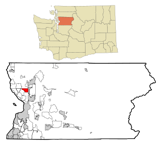
Lake Morton-Berrydale is a census-designated place (CDP) in King County, Washington, United States. The population was 10,474 at the 2020 census.

<span class="mw-page-title-main">Stimson Crossing, Washington</span> Former CDP in Washington, United States

Stimson Crossing is a former census-designated place (CDP) in Snohomish County, Washington, United States. The population was 773 at the 2000 census. The CDP was discontinued at the 2010 census.

<span class="mw-page-title-main">Loveland Park, Ohio</span> Census-designated place in Ohio, United States

Loveland Park is a census-designated place (CDP) located in Symmes Township, Hamilton County and Deerfield Township, Warren County, in the southwestern part of the U.S. state of Ohio. The CDP is named after the city of Loveland. The population was 1,737 at the 2020 census.

<span class="mw-page-title-main">West Seneca (CDP), New York</span> Census-designated place in New York, United States

West Seneca is a hamlet and census-designated place (CDP) in Erie County, New York, United States. The population was 44,711 at the 2010 census. It is part of the Buffalo–Niagara Falls Metropolitan Statistical Area. The CDP corresponds exactly to the area of the town of West Seneca.

References

  1. "ArcGIS REST Services Directory". United States Census Bureau. Retrieved September 20, 2022.
  2. "US Board on Geographic Names". United States Geological Survey. 2007-10-25. Retrieved 2008-01-31.
  3. 1 2 "U.S. Census website". United States Census Bureau . Retrieved 2008-01-31.
  4. U.S. Geological Survey Geographic Names Information System: Drexel, Ohio
  5. "Census of Population and Housing". Census.gov. Retrieved June 4, 2016.