
A swamp is a forested wetland. Swamps are considered to be transition zones because both land and water play a role in creating this environment. Swamps vary in size and are located all around the world. The water of a swamp may be fresh water, brackish water, or seawater. Freshwater swamps form along large rivers or lakes where they are critically dependent upon rainwater and seasonal flooding to maintain natural water level fluctuations. Saltwater swamps are found along tropical and subtropical coastlines. Some swamps have hammocks, or dry-land protrusions, covered by aquatic vegetation, or vegetation that tolerates periodic inundation or soil saturation. The two main types of swamp are "true" or swamp forests and "transitional" or shrub swamps. In the boreal regions of Canada, the word swamp is colloquially used for what is more formally termed a bog, fen, or muskeg. Some of the world's largest swamps are found along major rivers such as the Amazon, the Mississippi, and the Congo.
Starke County is a county in the U.S. state of Indiana. As of the 2020 United States Census, its population was 23,371. The county seat is Knox.

Porter County is a county in the U.S. state of Indiana. As of 2020, the population was 173,215, making it the 10th most populous county in Indiana. The county seat is Valparaiso. The county is part of Northwest Indiana, as well as the Chicago metropolitan area. Porter County is the site of much of the Indiana Dunes, an area of ecological significance. The Hour Glass Museum in Ogden Dunes documents the region's ecological significance.

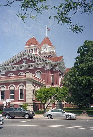
LaPorte County is a county located in the U.S. state of Indiana. As of 2020, the population was 112,417. The county seat is the city of La Porte, and the largest city is Michigan City. This county is part of the Northwest Indiana and Michiana regions of the Chicago metropolitan area. The LaPorte County Courthouse is located in the county seat of La Porte and is listed on the National Register of Historic Places.
Lake County is a county located in the U.S. state of Indiana. In 2020, its population was 498,700, making it Indiana's second-most populous county. The county seat is Crown Point. The county is part of Northwest Indiana and the Chicago metropolitan area, and contains a mix of urban, suburban and rural areas. It is bordered on the north by Lake Michigan and contains a portion of the Indiana Dunes. It includes Marktown, Clayton Mark's planned worker community in East Chicago.

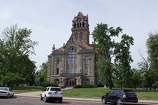
Jasper County is a county located in the U.S. state of Indiana. As of 2020, the population was 32,918. The county seat is Rensselaer.
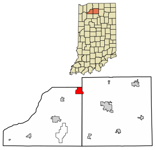
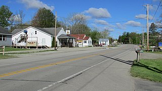
Koontz Lake is an unincorporated community and census-designated place in Starke and Marshall counties in Indiana. The population was 1,667 at the 2020 census.

Indiana Dunes National Park is a United States national park located in northwestern Indiana managed by the National Park Service. It was authorized by Congress in 1966 as the Indiana Dunes National Lakeshore and was redesignated as the nation's 61st national park on February 15, 2019. The park runs for about 20 miles (32 km) along the southern shore of Lake Michigan and covers 15,349 acres (6,212 ha). Along the lakefront, the eastern area is roughly the lake shore south to U.S. 12 or U.S. 20 between Michigan City, Indiana, on the east and the Cleveland-Cliffs steel plant on the west. This areas conservation scheme is enhanced by the older Indiana Dunes State Park. To the west of the steel plant lies West Beach and a small extension south of the steel mill continues west along Salt Creek to Indiana 249. The western area is roughly the shoreline south to U.S. 12 between the Burns Ditch west to Broadway in downtown Gary, Indiana. In addition, there are several outlying areas, including Pinhook Bog, in LaPorte County to the east; the Heron Rookery in Porter County, the center of the park; and the Calumet Prairie State Nature Preserve and the Hobart Prairie Grove, both in Lake County, the western end of the park.

The Kankakee River is a tributary of the Illinois River, approximately 133 miles (214 km) long, in the Central Corn Belt Plains of northwestern Indiana and northeastern Illinois in the United States. At one time, the river drained one of the largest wetlands in North America and furnished a significant portage between the Great Lakes and the Mississippi River. Significantly altered from its original channel, it flows through a primarily rural farming region of reclaimed cropland, south of Lake Michigan.
Northwest Indiana, nicknamed The Region after the Calumet Region, comprises Lake, Porter, LaPorte, and Newton counties in Indiana. This region neighbors Lake Michigan and is part of the Chicago metropolitan area. According to the 2020 Census, Northwest Indiana has a population of 831,080 and is the state's second largest urban area after the Indianapolis Metropolitan Area. It is also the home of the Indiana Dunes, parts of which have been preserved through conservation efforts. The town of Ogden Dunes houses the Hour Glass, a museum showcasing the ecological and conservation efforts of O. D. Frank.

The Iroquois River is a 103-mile-long (166 km) tributary of the Kankakee River in the Central Corn Belt Plains of northwestern Indiana and northeastern Illinois in the United States. It was named for the Iroquois people. Via the Kankakee and Illinois rivers, it is part of the watershed of the Mississippi River.

The Yellow River is a 62.3-mile-long (100.3 km) tributary of the Kankakee River in the Central Corn Belt Plains ecoregion, located in northern Indiana in the United States. Via the Kankakee and Illinois rivers, it is part of the watershed of the Mississippi River, draining an area of 427 square miles (1,110 km2).

Railroad Township is one of nine townships in Starke County, in the U.S. state of Indiana. As of the 2010 census, its population was 1,226 and it contained 549 housing units.
Fish Lake is an unincorporated community and census-designated place in Lincoln Township, LaPorte County, Indiana, United States. It is located where Indiana State Road 4 passes between Upper Fish Lake and Lower Fish Lake. These lakes feed the Kankakee River. As of the 2010 census, the population of the community was 1,016.

The Kankakee Outwash Plain is a flat plain interspersed with sand dunes in the Kankakee River valley in northwestern Indiana and northeastern Illinois of the United States. It is just south of the Valparaiso Moraine and was formed during the Wisconsin Glaciation. As the glacier stopped at the Valparaiso Moraine, its meltwater was carried away to the outwash plain. On the south side of the moraine, where the elevation drops, the meltwaters eroded away valleys, carrying sand and mud with them. As the muddy meltwater reached the valley where the slope lessened, the water slowed, depositing the sand on the outwash plain. This created a smooth, flat, and sandy plain. Before its draining, the Kankakee Marsh, located on the outwash plain, was one of the largest freshwater marshes in the United States.
The Kankakee Fish and Wildlife Area is situated in Starke County at the junction of the Yellow River with the Kankakee River. The state purchased 2,312 acres (9.36 km2) of marshland in 1927 for a Civilian Conservation Corp. camp. The camp consisted of up to 400 men. After the camp closed, it was established as a game preserve. In the 1950s waterfowl management was begun. In 1982 another 1,016 acres (4.11 km2) were added and in 1992 an additional 767 acres (3.10 km2). The Fish and Wildlife area consist of the wetlands between the Yellow River and the Kankakee at their junction and uplands on both the north bank of the Kankakee and the south bank of the Yellow. The main entrance to the area is on Indiana State Road 39 at Indiana State Road 8.

Lake Kankakee formed 14,000 years before present (YBP) in the valley of the Kankakee River. It developed from the outwash of the Michigan Lobe, Saginaw Lobe, and the Huron-Erie Lobe of the Wisconsin glaciation. These three ice sheets formed a basin across Northwestern Indiana. It was a time when the glaciers were receding, but had stopped for a thousand years in these locations. The lake drained about 13,000 YBP, until reaching the level of the Momence Ledge. The outcropping of limestone created an artificial base level, holding water throughout the upper basin, creating the Grand Kankakee Marsh.

The Marseilles moraine is a terminal moraine that encircles the southern tip of Lake Michigan in North America. It begins near Elgin, Illinois, and extends south and west of Chicago metropolitan area, turning eastward 30 miles (48 km) to 40 miles (64 km) south of the lake in Kankakee and Iroqouis counties, entering Indiana. It formed during the Wisconsin glaciation. The glacier had been in retreat when it stopped for an extended period, depositing glacial till and sand creating the hills of the moraine.
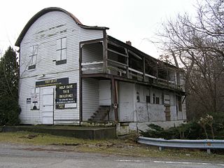
The Collier Lodge site, located in Porter County, Indiana, is one of the few places the Kankakee Marsh could be easily crossed. The site has been occupied for over 11,000 years with evidence of human occupation from 1,000 B.C.E. Historic records of humans occupation in northwestern Indiana are available from the late seventeenth century. The prehistoric and historic cultural deposits are unique for northwestern Indiana. Prehistoric artifacts from the site represent most time periods over the last nine to ten thousand years and historic artifacts span the full range of historic occupations in northwestern Indiana. Prehistoric archaeological features documented at the site include two different types of roasting pits and small features whose functions are unknown. Historic features include the remains of a fireplace, post molds, and what is now thought to be a cellar marks the location of a previously undocumented structure. Concentrations of animal bones from the early nineteenth century indicate furs were processed at the site.
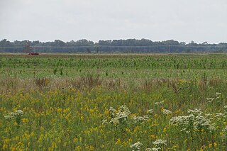
Beaver Lake, now drained, was one of the largest lakes in Indiana. It was a shallow lake covering tens of thousands of acres and did not exceed fifteen feet in depth. Beaver Lake was home to, and provided water for, scores of species of fish, waterfowl and mammals. Among the animals native to the area was a healthy Bald Eagle population. Before the settlement of Newton County, Indiana it provided food, furs and shelter for Native Americans. During Indiana's frontier days the lake continued to provide food and furs for the early settlers. Thanks to its remoteness, criminals were known to hideout at the infamous Bogus Island located on the Lake. In 1853, a ditch connecting it to the nearby Kankakee River was dug and the process of draining the lake began. Until the lake was drained and the river was dredged, the Kankakee River and Beaver Lake were part of North America's largest inland swamp. It took a little over twenty years to completely drain the lake. Once it was drained the land was converted to farmland.


