San Pierre, Indiana

Last updated

San Pierre, Indiana
Starke County Indiana Incorporated and Unincorporated areas San Pierre Highlighted 1868004.svg
Location of San Pierre in Starke County, Indiana.
Coordinates: 41°11′57″N86°53′27″W / 41.19917°N 86.89083°W / 41.19917; -86.89083
Country United States
State Indiana
County Starke
Township Railroad
Area
[1]
  Total0.14 sq mi (0.38 km2)
  Land0.14 sq mi (0.38 km2)
  Water0.00 sq mi (0.00 km2)
Elevation
[2]
702 ft (214 m)
Population
 (2020)
  Total153
  Density1,055.17/sq mi (407.09/km2)
Time zone UTC-6 (Central (CST))
  Summer (DST) UTC-5 (CDT)
ZIP code
46374
Area code 219
FIPS code 18-68004 [3]
GNIS feature ID2393222 [2]

San Pierre is a census-designated place (CDP) in Railroad Township, Starke County, in the U.S. state of Indiana. [2] The population was 144 at the 2010 census. [4]

Contents

History

San Pierre, 1880s San Pierre, Indiana (1880s).jpg
San Pierre, 1880s

Established and laid out in 1854, the area was originally called Culvertown, [5] although a post office had been established as River in 1853. According to one local tradition, the village later took the name of San Pierre, named after a nearby French-Canadian saloon owner. The story goes that 'Pierre' built a shack some 400 feet south of the village of Culvertown and began to sell whisky there. As a consequence of this inducement, the town shifted slightly to the south and the name was changed to San Pierre. [6] Another tradition records the village being named after a French railroad worker called 'Pierre', with San being added to provide more importance to the name. [7] In any case, the name was changed simply to Pierre in 1894, possibly as a result of increasing tension between Spain and the United States, leading up to the Spanish–American War. [7] Finally the name was changed back to San Pierre in 1899. [6] [8]

Sandhill Cranes

Due to its closeness to the Jasper-Pulaski Fish and Wildlife Area, each year San Pierre and the surrounding vicinity is briefly home to more than 10,000 of the sandhill crane species of bird during their fall migration. [9] The bird has become so synonymous with the town that it has become an unofficial emblem of the community, including a depiction on the welcome sign.

Geography

San Pierre is located at the junction of U.S. Route 421 and Indiana State Road 10.

According to the United States Census Bureau, the CDP has a total area of 0.1 square miles (0.26 km2), all land.

Demographics

Historical population
CensusPop.Note
2020 153
U.S. Decennial Census [10]
Welcome sign near the junction of highways 421 and 10 San Pierre, Indiana welcome.png
Welcome sign near the junction of highways 421 and 10

As of the census [3] of 2000, there were 156 people, 71 households, and 39 families residing in the CDP. The population density was 1,100.2 inhabitants per square mile (424.8/km2). There were 77 housing units at an average density of 543.0 per square mile (209.7/km2). The racial makeup of the CDP was 98.72% White, 0.64% Native American, 0.64% from other races. Hispanic or Latino of any race were 0.64% of the population.

There were 71 households, out of which 25.4% had children under the age of 18 living with them, 40.8% were married couples living together, 14.1% had a female householder with no husband present, and 43.7% were non-families. 36.6% of all households were made up of individuals, and 25.4% had someone living alone who was 65 years of age or older. The average household size was 2.20 and the average family size was 2.93.

In the CDP, the population was spread out, with 22.4% under the age of 18, 5.1% from 18 to 24, 23.1% from 25 to 44, 24.4% from 45 to 64, and 25.0% who were 65 years of age or older. The median age was 45 years. For every 100 females, there were 95.0 males. For every 100 females age 18 and over, there were 89.1 males.

The median income for a household in the CDP was $30,500, and the median income for a family was $39,375. Males had a median income of $20,000 versus $18,750 for females. The per capita income for the CDP was $13,552. None of the population or families were below the poverty line.

Education

San Pierre has a public library, a branch of the Starke County Public Library System. [11]

Related Research Articles

<span class="mw-page-title-main">Bloomington, California</span> Place in California, United States

Bloomington is an unincorporated community in San Bernardino County, California, United States. The population was 23,851 at the 2010 census, up from 19,318 at the 2000 census. For statistical purposes, the United States Census Bureau has defined Bloomington as a census-designated place (CDP).

<span class="mw-page-title-main">Taylorsville, Indiana</span> CDP in Indiana, United States

Taylorsville is a census-designated place (CDP) in German Township, Bartholomew County, in the U.S. state of Indiana. The population was 919 at the 2010 census. It is part of the Columbus, Indiana metropolitan statistical area.

<span class="mw-page-title-main">Simonton Lake, Indiana</span> Census-designated place in Indiana, United States

Simonton Lake is a census-designated place (CDP) in Elkhart County, Indiana, United States. The population was 4,678 at the 2010 census.

<span class="mw-page-title-main">Collegeville, Indiana</span> Census-designated place in Indiana, United States

Collegeville is a census-designated place (CDP) in Jasper County, Indiana, United States. The population was 330 at the 2010 census. Collegeville is home to the now-unaccredited Saint Joseph's College, the source of the town's name.

<span class="mw-page-title-main">Lakes of the Four Seasons, Indiana</span> Census-designated place in Indiana, United States

Lakes of the Four Seasons is a census-designated place (CDP) in Lake and Porter counties in the U.S. state of Indiana. The population was 7,033 at the 2010 census.

<span class="mw-page-title-main">Koontz Lake, Indiana</span> Census-designated place in Indiana, United States

Koontz Lake is an unincorporated community and census-designated place in Starke and Marshall counties in Indiana. The population was 1,667 at the 2020 census.

<span class="mw-page-title-main">Star City, Indiana</span> Census-designated place in Indiana, United States

Star City is a census-designated place (CDP) in Van Buren Township, Pulaski County, in the U.S. state of Indiana. The population was 344 at the 2010 census.

<span class="mw-page-title-main">Georgetown, St. Joseph County, Indiana</span> Census-designated place in Indiana, United States

Georgetown is a census-designated place in Clay Township, St. Joseph County, in the U.S. state of Indiana. The population was 4,497 at the 2000 census. It is part of the South Bend–Mishawaka, IN-MI, Metropolitan Statistical Area.

<span class="mw-page-title-main">Bass Lake, Indiana</span> Census-designated place in Indiana, United States

Bass Lake is a census-designated place (CDP) in California and North Bend Townships, Starke County, in the U.S. state of Indiana. The population was 1,195 at the 2010 census.

<span class="mw-page-title-main">Hamlet, Indiana</span> Town in Starke County, Indiana, United States

Hamlet is a town in Davis and Oregon Townships, Starke County, in the U.S. state of Indiana. The population was 800 as of the 2010 census.

<span class="mw-page-title-main">Knox, Indiana</span> City in Indiana, United States

Knox is a city in Center Township, Starke County, in the U.S. state of Indiana. The population was 3,704 at the 2010 census. The city is the county seat of Starke County.

<span class="mw-page-title-main">North Judson, Indiana</span> Town in Indiana, United States

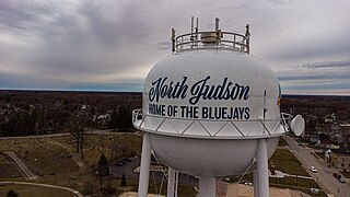
North Judson is a town in Wayne Township, Starke County, in the U.S. state of Indiana. The population was 1,857 as of the 2020 census.

<span class="mw-page-title-main">Highland, Vanderburgh County, Indiana</span> Census-designated place in Indiana, United States

Highland is a census-designated place (CDP) in Center Township, Vanderburgh County, in the U.S. state of Indiana. The population was 4,489 at the 2010 census.

<span class="mw-page-title-main">North Terre Haute, Indiana</span> Census-designated place in Indiana, United States

North Terre Haute is a census-designated place (CDP) in Otter Creek Township, Vigo County, in the U.S. state of Indiana. The population was 4,305 at the 2010 census. It is part of the Terre Haute Metropolitan Statistical Area.

<span class="mw-page-title-main">Naschitti, New Mexico</span> CDP in New Mexico, United States

Naschitti is a census-designated place (CDP) in San Juan County, New Mexico, United States. The population was 360 at the 2000 census. It is part of the Farmington Metropolitan Statistical Area. The town was established in 1886, when Tom Bryan set up a trading post east of the Chuska Mountains. With a Navajo name, Naschitti means "badger springs."

Jacksonville is a census-designated place (CDP) in Indiana County, Pennsylvania, United States. The population was 637 at the 2010 census. It was formerly an independent borough, until January 1, 1993 when it was returned to Black Lick Township, Pennsylvania.

<span class="mw-page-title-main">Rosebud, South Dakota</span> CDP in South Dakota, United States

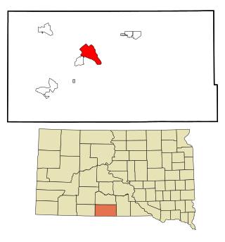
Rosebud also Sicanġu is a census-designated place (CDP) in Todd County, South Dakota, United States. The population was 1,455 at the 2020 census.

<span class="mw-page-title-main">White Horse, South Dakota</span> CDP in South Dakota, United States

White Horse also Šuŋgská oyáŋke is a census-designated place (CDP) in Todd County, South Dakota, United States. The population was 234 at the 2020 census.

<span class="mw-page-title-main">Bloomington, Texas</span> Census-designated place in Texas, United States

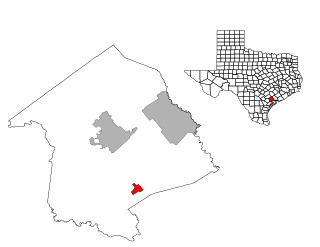
Bloomington is a census-designated place (CDP) in Victoria County, Texas, United States. The population was 2,459 at the 2010 census. It is included in the Victoria, Texas Metropolitan Statistical Area.

<span class="mw-page-title-main">Tselakai Dezza, Utah</span> CDP in Utah, United States

Tselakai Dezza is a census-designated place (CDP) in San Juan County, Utah, United States. The population was 103 at the 2000 census.

References

  1. "2020 U.S. Gazetteer Files". United States Census Bureau. Retrieved March 16, 2022.
  2. 1 2 3 U.S. Geological Survey Geographic Names Information System: San Pierre, Indiana
  3. 1 2 "U.S. Census website". United States Census Bureau . Retrieved January 31, 2008.
  4. Bureau, U.S. Census. "U.S. Census website". United States Census Bureau . Retrieved October 2, 2017.
  5. "Stark County, Indiana, 1857 - House Divided". Housedivided.dickinson.edu. Archived from the original on July 9, 2012. Retrieved October 2, 2017.
  6. 1 2 Baker, Ronald L. (1995). From Needmore to Prosperity . Bloomington: Indiana University Press. p.  294. ISBN   0-253-20955-2.
  7. 1 2 "What's in a Name?" (PDF). Scpl.lib.in.us. Retrieved October 2, 2017.
  8. Baker, Ronald L.; Marvin Carmony (1995). Indiana Place Names. Bloomington: Indiana University Press. p. 148. ISBN   0-253-28340-X.
  9. "Community Assets". Ists.org. Retrieved October 2, 2017.
  10. "Census of Population and Housing". Census.gov. Retrieved June 4, 2016.
  11. "Hours & Locations". Starke County Public Library System. Retrieved March 15, 2018.