Flatlands, New Brunswick

Last updated

Flatlands
Canada New Brunswick location map 2.svg
Red pog.svg
Location of Flatlands, New Brunswick
Coordinates: 47°59′00″N66°53′00″W / 47.983333°N 66.883333°W / 47.983333; -66.883333 Coordinates: 47°59′00″N66°53′00″W / 47.983333°N 66.883333°W / 47.983333; -66.883333
Country Flag of Canada (Pantone).svg  Canada
Province Flag of New Brunswick.svg  New Brunswick
County Restigouche
Parish Addington
Electoral Districts
Federal

Madawaska—Restigouche
Provincial Restigouche West
Government
  Type Local service district
Area
  Land18.94 km2 (7.31 sq mi)
Population
 (2016)
  Total143
  Density7.55/km2 (19.6/sq mi)
  Pop 2011-2016
Decrease2.svg 15.9%
  Dwellings
83
Time zone UTC-4 (AST)
  Summer (DST) UTC-3 (ADT)
Postal code(s)
E3N
  • 0A5, 0A8
  • 4X2-4X3, 4X5-4X6
  • 5A4
Area code 506
Access RoutesNB 11.svg Route 11

Flatlands was a local service district in Addington Parish, Restigouche County, New Brunswick, Canada. [1] The Duncan family of Aberdeen, Scotland were the original settlers of Flatlands and Campbellton.[ citation needed ] In 1866 Flatlands was a farming and lumbering settlement with approximately 27 resident families. [2] In 1871, it had a population of 150. [2] In 1898 Flatlands was a station on the Intercolonial Railway and had one post office, three stores, a shingle mill, a church and a population of about 400. [2]

The population as of 2016 is 143 people. [3] [4]

Location

Flatlands is located along the Restigouche River, opposite the Province of Quebec. It is approximately 5 km from Matapédia, Quebec, a 5-minute drive, and about 15 km from downtown Campbellton, New Brunswick, a 20-minute drive. [5] [6] Route 11 is the major highway running through the community, with a posted speed limit of 80 km/h. [7]

Related Research Articles

<span class="mw-page-title-main">Campbellton, New Brunswick</span> City in New Brunswick, Canada

Campbellton is a city in Restigouche County, New Brunswick, Canada.

<span class="mw-page-title-main">New Brunswick Route 11</span> Highway in New Brunswick

Route 11 is a provincial highway in northeastern New Brunswick, Canada. The 440-kilometre (270 mi) road runs from Moncton to the Quebec border, near Campbellton, at the Matapédia Bridge, following the province's eastern and northern coastlines.

<span class="mw-page-title-main">Restigouche River</span> River in New Brunswick, Canada

The Restigouche River is a river that flows across the northwestern part of the province of New Brunswick and the southeastern part of Quebec.

<span class="mw-page-title-main">Quebec Route 132</span> Highway in Quebec

Route 132 is the longest highway in Quebec. It follows the south shore of the Saint Lawrence River from the border with the state of New York in the hamlet of Dundee, west of Montreal to the Gulf of Saint Lawrence and circles the Gaspé Peninsula. This highway is known as the Navigator's Route. It passes through the Montérégie, Centre-du-Québec, Chaudière-Appalaches, Bas-Saint-Laurent and Gaspésie regions of the province.

Dalhousie is an unincorporated community in the town of Heron Bay, New Brunswick, Canada. It held town status prior to 2023. New Brunswick's northernmost point of land is situated in Dalhousie, where the Restigouche River meets Chaleur Bay.

<span class="mw-page-title-main">J. C. Van Horne Bridge</span> Bridge in Quebec, Listuguj Miꞌgmaq First Nation

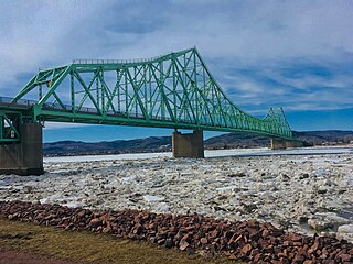
The J. C. Van Horne Bridge is a Canadian steel through truss/steel deck truss bridge crossing the Restigouche River between Campbellton, New Brunswick and Pointe-à-la-Croix, Quebec.

<span class="mw-page-title-main">Atholville, New Brunswick</span> Community within the City of Campbellton

Atholville is an unincorporated community in Restigouche County, New Brunswick, Canada. It held village status prior to 2023.

Kedgwick is a Canadian incorporated rural community in northern New Brunswick, Canada. On 1 January 2023, Kedgwick annexed a large area including the local service districts of St. Jean Baptiste – Menneval and White's Brook, with parts of two others; revised census figures have not been released.

<span class="mw-page-title-main">Matapédia, Quebec</span> Municipality in Quebec, Canada

Matapédia is a municipality at the southern tip of the Gaspé Peninsula, in eastern Quebec, Canada. Matapédia is located along Quebec Route 132 on the border of New Brunswick.

<span class="mw-page-title-main">Addington Parish, New Brunswick</span> Parish in New Brunswick, Canada

Addington is a civil parish in Restigouche County, New Brunswick, Canada.

The Matapédia Bridge crosses the Restigouche River from Matapédia, Quebec to Flatlands, New Brunswick, connecting New Brunswick Route 11 to Quebec Route 132. It was built in 1974, and is 419 metres (1,375 ft) long.

Route 134 is a 261 km (162 mi)-long north–south secondary highway in eastern New Brunswick, Canada. The highway is divided by into a northern and southern section by a gap in Northumberland County connected by Route 11 and Route 8.

<span class="mw-page-title-main">Dalhousie Parish, New Brunswick</span> Parish in New Brunswick, Canada

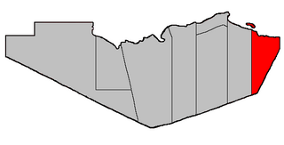
Dalhousie is a civil parish in Restigouche County, New Brunswick, Canada.

<span class="mw-page-title-main">Balmoral Parish, New Brunswick</span> Parish in New Brunswick, Canada

Balmoral is a civil parish in Restigouche County, New Brunswick, Canada.

<span class="mw-page-title-main">Eldon Parish, New Brunswick</span> Parish in New Brunswick, Canada

Eldon is a civil parish in Restigouche County, New Brunswick, Canada.

<span class="mw-page-title-main">Grimmer Parish, New Brunswick</span> Former Parish in New Brunswick, Canada

Grimmer is a civil parish in Restigouche County, New Brunswick, Canada.

<span class="mw-page-title-main">Durham Parish, New Brunswick</span> Parish in New Brunswick, Canada

Durham is a civil parish in Restigouche County, New Brunswick, Canada.

<span class="mw-page-title-main">Saint-Quentin Parish, New Brunswick</span> Parish in New Brunswick, Canada

Saint-Quentin is a civil parish in Restigouche County, New Brunswick, Canada.

<span class="mw-page-title-main">Vitalité Health Network</span>

Vitalité Health Network is one of two health authorities in the Canadian province of New Brunswick, the other being Horizon Health Network.

<span class="mw-page-title-main">Administrative divisions of New Brunswick</span> Local governance in New Brunswick

The Canadian province of New Brunswick is divided into 89 local entities, consisting of 77 local governments and 12 rural districts.

References

  1. New Brunswick Provincial Archives - Flatlands
  2. 1 2 3 "Flatlands". Provincial Archives of New Brunswick. Retrieved 15 May 2012.
  3. "Census Profile, 2016 Census Flatlands part A, Local service district [Designated place], New Brunswick and New Brunswick [Province]". Statistics Canada. Retrieved November 17, 2018.
  4. "Census Profile, 2016 Census Flatlands part B, Local service district [Designated place], New Brunswick and New Brunswick [Province]". Statistics Canada. Retrieved November 17, 2018.
  5. "Google Maps | Get Directions - Flatlands NB to Matapédia QC". Google Maps. Retrieved April 21, 2019.
  6. "Google Maps | Get Directions - Flatlands NB to Campbellton NB". Google Maps. Retrieved April 21, 2019.
  7. "Google Maps | Street View - Route 11 Flatlands NB". Google Maps. Retrieved April 21, 2019.