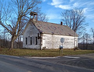
Flora, Ohio

Last updated

Flora is an extinct town in Meigs County, in the U.S. state of Ohio. The GNIS classifies it as a populated place. [1]

Meigs County, Ohio County in the United States

Meigs County is a county located in the U.S. state of Ohio. As of the 2010 census, the population was 23,770. Its county seat is Pomeroy. The county is named for Return J. Meigs, Jr., the fourth Governor of Ohio.

U.S. state constituent political entity of the United States

In the United States, a state is a constituent political entity, of which there are currently 50. Bound together in a political union, each state holds governmental jurisdiction over a separate and defined geographic territory and shares its sovereignty with the federal government. Due to this shared sovereignty, Americans are citizens both of the federal republic and of the state in which they reside. State citizenship and residency are flexible, and no government approval is required to move between states, except for persons restricted by certain types of court orders. Four states use the term commonwealth rather than state in their full official names.

Ohio State of the United States of America

Ohio is a Midwestern state in the Great Lakes region of the United States. Of the fifty states, it is the 34th largest by area, the seventh most populous, and the tenth most densely populated. The state's capital and largest city is Columbus.

History

A post office was established at Flora in 1884, and remained in operation until 1949. [2] An early settler gave the community the name of his daughter Flora. [3]

Related Research Articles

Anita, California Former settlement in California, United States

Anita is an unincorporated community in Butte County, California. It is located 2.5 miles (4.0 km) north-northwest of Nord, along the Southern Pacific Railroad, at an elevation of 157 feet.

Milton, Ohio County, Indiana Unincorporated Community in Indiana, United States

Milton is an unincorporated community in Union Township, Ohio County, in the U.S. state of Indiana.

Hoskinsville is an unincorporated community in Noble County, in the U.S. state of Ohio.

Equity is an unincorporated community in Washington County, in the U.S. state of Ohio.

Gracey is an unincorporated community in Washington County, in the U.S. state of Ohio.

Grandview is an unincorporated community in Washington County, in the U.S. state of Ohio.

Qualey is an unincorporated community in Washington County, in the U.S. state of Ohio.

Coal Hill is an extinct town in Muskingum County, in the U.S. state of Ohio. The GNIS classifies it as a populated place.

Baileys Mills is an unincorporated community in Belmont County, in the U.S. state of Ohio.

Bridges is an unincorporated community in Highland County, in the U.S. state of Ohio.

Cannelville is an unincorporated community in Muskingum County, in the U.S. state of Ohio.

Claysville, Ohio human settlement in United States of America

Claysville is an unincorporated community in Guernsey County, in the U.S. state of Ohio.

Fifteen is an unincorporated community in Washington County, in the U.S. state of Ohio.

Guernsey is an unincorporated community in Guernsey County, in the U.S. state of Ohio.

Kelsey is an extinct town in Belmont County, in the U.S. state of Ohio.

Meigs is an unincorporated community in Morgan County, in the U.S. state of Ohio.

Neelysville is an unincorporated community in Morgan County, in the U.S. state of Ohio.

Plano is an unincorporated community in Fayette and Ross counties, in the U.S. state of Ohio.

Robins is an unincorporated community in Guernsey County, in the U.S. state of Ohio.

Western Star is an unincorporated community in Medina and Summit counties, in the U.S. state of Ohio.

References

Coordinates: 39°09′53″N81°58′42″W / 39.16472°N 81.97833°W / 39.16472; -81.97833

Geographic coordinate system Coordinate system

A geographic coordinate system is a coordinate system that enables every location on Earth to be specified by a set of numbers, letters or symbols. The coordinates are often chosen such that one of the numbers represents a vertical position and two or three of the numbers represent a horizontal position; alternatively, a geographic position may be expressed in a combined three-dimensional Cartesian vector. A common choice of coordinates is latitude, longitude and elevation. To specify a location on a plane requires a map projection.