Middleport, Ohio

Last updated

Middleport, Ohio
Middleport Ohio 2nd Avenue.jpg
North 2nd Avenue in downtown Middleport in 2007
OHMap-doton-Middleport.png
Location of Middleport, Ohio
Map of Meigs County Ohio Highlighting Middleport Village.png
Location of Middleport in Meigs County
Coordinates: 38°00′05″N82°03′30″W / 38.00139°N 82.05833°W / 38.00139; -82.05833
Country United States
State Ohio
County Meigs
Township Salisbury
Area
[1]
  Total1.90 sq mi (4.91 km2)
  Land1.80 sq mi (4.66 km2)
  Water0.10 sq mi (0.25 km2)
Elevation
[2]
568 ft (173 m)
Population
 (2020)
  Total2,208
  Density1,228.03/sq mi (474.07/km2)
Time zone UTC-5 (Eastern (EST))
  Summer (DST) UTC-4 (EDT)
ZIP code
45760
Area code 740
FIPS code 39-49756 [3]
GNIS feature ID2399333 [2]
Website Village website

Middleport is the largest village in Meigs County, Ohio, along the Ohio River. The population was 2,208 at the time of the 2020 census.

Contents

History

Soldiers and Sailors Monument Middleport Monument.jpg
Soldiers and Sailors Monument

Middleport was founded during the 1820s, a time of great prosperity and rapidly increasing commerce in Meigs County. Among its earliest industries was a cotton mill, built despite the lack of cotton production in the vicinity. The village was founded as "Sheffield", [4] and throughout its history it has also used the names of "Coalport" and "Salisbury". [5] The name Middleport refers to the city's location on the Ohio River halfway between Pittsburgh and Cincinnati. [6] Three Middleport buildings, the John Downing Jr. House, the William H. Grant House, and the Middleport Public Library, are listed on the National Register of Historic Places. [7]

Geography

Middleport is located along the Ohio River at the mouth of Leading Creek. [8]

According to the United States Census Bureau, the village has a total area of 1.90 square miles (4.92 km2), of which 1.80 square miles (4.66 km2) is land and 0.10 square miles (0.26 km2) is water. [9]

Demographics

Historical population
CensusPop.Note
1870 2,236
1880 3,03235.6%
1890 3,2115.9%
1900 2,799−12.8%
1910 3,19414.1%
1920 3,77218.1%
1930 3,505−7.1%
1940 3,356−4.3%
1950 3,4462.7%
1960 3,373−2.1%
1970 2,784−17.5%
1980 2,9716.7%
1990 2,725−8.3%
2000 2,525−7.3%
2010 2,5300.2%
2020 2,208−12.7%
U.S. Decennial Census [10]

2010 census

As of the census [11] of 2010, there were 2,530 people, 1,089 households, and 649 families living in the village. The population density was 1,405.6 inhabitants per square mile (542.7/km2). There were 1,299 housing units at an average density of 721.7 per square mile (278.6/km2). The racial makeup of the village was 94.5% White, 3.0% African American, 0.4% Native American, 0.2% Asian, 0.2% from other races, and 1.6% from two or more races. Hispanic or Latino of any race were 0.6% of the population.

There were 1,089 households, of which 28.9% had children under the age of 18 living with them, 36.4% were married couples living together, 16.5% had a female householder with no husband present, 6.7% had a male householder with no wife present, and 40.4% were non-families. 35.9% of all households were made up of individuals, and 16.1% had someone living alone who was 65 years of age or older. The average household size was 2.23 and the average family size was 2.84.

The median age in the village was 42.5 years. 21.3% of residents were under the age of 18; 8.2% were between the ages of 18 and 24; 23.4% were from 25 to 44; 26.6% were from 45 to 64; and 20.4% were 65 years of age or older. The gender makeup of the village was 46.1% male and 53.9% female.

2000 census

As of the census [3] of 2000, there were 2,525 people, 1,103 households, and 659 families living in the village. The population density was 1,396.1 inhabitants per square mile (539.0/km2). There were 1,243 housing units at an average density of 687.3 per square mile (265.4/km2). The racial makeup of the village was 95.64% White, 2.38% African American, 0.36% Native American, 0.16% Asian, 0.12% from other races, and 1.35% from two or more races. Hispanic or Latino of any race were 0.55% of the population.

There were 1,103 households, out of which 27.1% had children under the age of 18 living with them, 41.5% were married couples living together, 14.0% had a female householder with no husband present, and 40.2% were non-families. 35.7% of all households were made up of individuals, and 17.6% had someone living alone who was 65 years of age or older. The average household size was 2.23 and the average family size was 2.89.

In the village, the population was spread out, with 22.9% under the age of 18, 9.2% from 18 to 24, 24.5% from 25 to 44, 23.3% from 45 to 64, and 20.1% who were 65 years of age or older. The median age was 40 years. For every 100 females, there were 81.7 males. For every 100 females age 18 and over, there were 77.6 males.

The median income for a household in the village was $22,532, and the median income for a family was $29,349. Males had a median income of $27,264 versus $21,875 for females. The per capita income for the village was $13,138. About 16.3% of families and 24.1% of the population were below the poverty line, including 30.4% of those under age 18 and 17.6% of those age 65 or over.

Education

Public education in the village of Middleport is provided by the Meigs Local School District. Campuses serving the village include Meigs Primary School (Grades K-2), Meigs Intermediate School (Grades 3–5), Meigs Middle School (Grades 6–8), and Meigs High School (Grades 9-12).

Middleport has a public library, a branch of the Meigs County District Public Library. [12]

Notable people

Related Research Articles

<span class="mw-page-title-main">Meigs County, Ohio</span> County in Ohio, United States

Meigs County is a county located in the U.S. state of Ohio. As of the 2020 census, the population was 22,210. Its county seat is Pomeroy. The county is named for Return J. Meigs Jr., the fourth Governor of Ohio.

<span class="mw-page-title-main">Middleport, New York</span> Village in New York, United States

Middleport is a village in Niagara County, New York, United States. The population was 1,840 at the 2010 census. The mail ZIP code is 14105. It is part of the Buffalo–Niagara Falls Metropolitan Statistical Area.

<span class="mw-page-title-main">Royalton, New York</span> Town in New York, United States

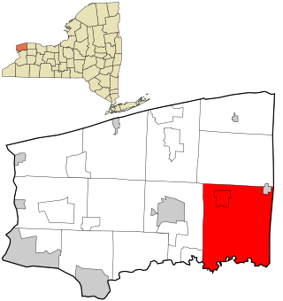
Royalton is a town in Niagara County, New York, United States. The population was 7,660 at the 2010 census.

<span class="mw-page-title-main">Coolville, Ohio</span> Village in Ohio, United States

Coolville is a village located in Troy Township, Athens County, Ohio, United States, in the southeast area of the state. The population was 452 at the 2020 census.

<span class="mw-page-title-main">Addyston, Ohio</span> Village in Ohio, United States

Addyston is a village in Miami Township, Hamilton County, Ohio, United States. Located along the Ohio River, it is a western suburb of the neighboring city of Cincinnati. The population was 927 at the 2020 census.

<span class="mw-page-title-main">Cleves, Ohio</span> City in Ohio, United States

Cleves is a village in Miami Township, Hamilton County, Ohio, United States. Located along the Ohio River, it is a western suburb of Cincinnati. The population was 3,414 at the 2020 census.

<span class="mw-page-title-main">Evendale, Ohio</span> Village in Ohio, United States

Evendale is a village in Hamilton County, Ohio, United States, within the Cincinnati metropolitan area. The population was 2,669 at the 2020 census.

<span class="mw-page-title-main">Mowrystown, Ohio</span> Village in Ohio, United States

Mowrystown is a village in Highland County, Ohio, United States. The population was 385 at the 2020 census.

<span class="mw-page-title-main">Gann, Ohio</span> Village in Ohio, United States

Brinkhaven, once known as Mount Holly and Gann, is a village in Knox County, Ohio, United States. The population was 114 at the 2020 census.

<span class="mw-page-title-main">Grafton, Ohio</span> Village in Ohio, United States

Grafton is a village in Lorain County, Ohio, United States, along the East Branch of the Black River. The population was 5,895 at the 2020 census. The Lorain Correctional Institution and several other prisons are located in and near Grafton.

<span class="mw-page-title-main">Pomeroy, Ohio</span> Village in Ohio, United States

Pomeroy is a village in and the county seat of Meigs County, Ohio, United States, along the Ohio River about 21 miles (34 km) south of Athens. The population was 1,573 at the 2020 census.

<span class="mw-page-title-main">Racine, Ohio</span> Village in Ohio, United States

Racine is a village in Meigs County, Ohio, United States, along the Ohio River. The population was 683 at the 2020 census.

<span class="mw-page-title-main">Syracuse, Ohio</span> Village in Ohio, United States

Syracuse is a village in Meigs County, Ohio, United States, along the Ohio River. The population was 781 at the 2020 census.

<span class="mw-page-title-main">Darbyville, Ohio</span> Village in Ohio, United States

Darbyville is a village in Pickaway County, Ohio, United States. The population was 186 at the 2020 census.

<span class="mw-page-title-main">Cloverdale, Ohio</span> Village in Ohio, United States

Cloverdale is a village in Perry Township, Putnam County, Ohio, United States. The population was 170 at the 2020 census.

<span class="mw-page-title-main">Limaville, Ohio</span> Census-designated place in Ohio, United States

Limaville is a census-designated place (CDP) and former village in Stark County, Ohio, United States. The population was 151 at the 2020 census. It is part of the Canton–Massillon Metropolitan Statistical Area.

<span class="mw-page-title-main">Clinton, Ohio</span> Village in Ohio, United States

Clinton is a village in southwestern Summit County, Ohio, United States. The population was 1,197 at the 2020 Census. It is part of the Akron metropolitan area.

<span class="mw-page-title-main">Macksburg, Ohio</span> Village in Ohio, United States

Macksburg is a village in Washington County, Ohio, United States, along the West Fork of Duck Creek. The population was 120 at the 2020 census. The village is about 28 miles (45 km) south of Cambridge, Ohio.

<span class="mw-page-title-main">Upper Sandusky, Ohio</span> City in Ohio, United States

Upper Sandusky is a city in and the county seat of Wyandot County, Ohio, United States, along the upper Sandusky River. The city lies approximately 59 miles (95 km) south of Toledo and 62 miles (100 km) north of Columbus. The population was 6,698 at the 2020 census.

<span class="mw-page-title-main">Rutland, Ohio</span> Village in Ohio, United States

Rutland is a village in Meigs County, Ohio, United States. The population was 427 at the 2020 census.

References

  1. "ArcGIS REST Services Directory". United States Census Bureau. Retrieved September 20, 2022.
  2. 1 2 U.S. Geological Survey Geographic Names Information System: Middleport, Ohio
  3. 1 2 "U.S. Census website". United States Census Bureau . Retrieved January 31, 2008.
  4. Larkin, Stillman Carter. The Pioneer History of Meigs County . Columbus: Berlin, 1908, 6-7.
  5. U.S. Geological Survey Geographic Names Information System: Middleport, Ohio
  6. Peacefull, Leonard (1996). A Geography of Ohio. Kent State University Press. p. 217. ISBN   9780873385251 . Retrieved December 8, 2013.
  7. "National Register Information System". National Register of Historic Places . National Park Service. July 9, 2010.
  8. Ohio Atlas & Gazetteer. Yarmouth, Me.: DeLorme. 1991. p. 87. ISBN   0-89933-233-1.
  9. "US Gazetteer files 2010". United States Census Bureau. Archived from the original on January 25, 2012. Retrieved January 6, 2013.
  10. "Census of Population and Housing". Census.gov. Retrieved June 4, 2015.
  11. "U.S. Census website". United States Census Bureau . Retrieved January 6, 2013.
  12. "Hours and Locations". Meigs County District Public Library. Retrieved March 1, 2018.