Letart Falls, Ohio

Last updated

Letart Falls is an unincorporated community in Meigs County, in the U.S. state of Ohio. [1]

Meigs County, Ohio County in the United States

Meigs County is a county located in the U.S. state of Ohio. As of the 2010 census, the population was 23,770. Its county seat is Pomeroy. The county is named for Return J. Meigs, Jr., the fourth Governor of Ohio.

U.S. state constituent political entity of the United States

In the United States, a state is a constituent political entity, of which there are currently 50. Bound together in a political union, each state holds governmental jurisdiction over a separate and defined geographic territory and shares its sovereignty with the federal government. Due to this shared sovereignty, Americans are citizens both of the federal republic and of the state in which they reside. State citizenship and residency are flexible, and no government approval is required to move between states, except for persons restricted by certain types of court orders. Four states use the term commonwealth rather than state in their full official names.

Ohio State of the United States of America

Ohio is a Midwestern state in the Great Lakes region of the United States. Of the fifty states, it is the 34th largest by area, the seventh most populous, and the tenth most densely populated. The state's capital and largest city is Columbus.

History

A post office called Letart Falls was established in 1826, and remained in operation until 1959. [2] There were formerly falls on the Ohio River at this point. [3]

Rapids A section of a river where the river bed is relatively steep, increasing the waters velocity and turbulence

Rapids are sections of a river where the river bed has a relatively steep gradient, causing an increase in water velocity and turbulence.

Ohio River river in the midwestern United States

The Ohio River is a 981-mile (1,579 km) long river in the midwestern United States that flows southwesterly from western Pennsylvania south of Lake Erie to its mouth on the Mississippi River at the southern tip of Illinois. It is the second largest river by discharge volume in the United States and the largest tributary by volume of the north-south flowing Mississippi River that divides the eastern from western United States. The river flows through or along the border of six states, and its drainage basin includes parts of 15 states. Through its largest tributary, the Tennessee River, the basin includes several states of the southeastern U.S. It is the source of drinking water for three million people.

Related Research Articles

Ravenswood Bridge

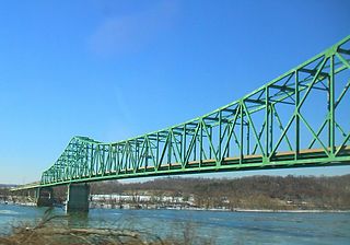
The William S. Ritchie Jr. Bridge, more commonly known as the Ravenswood Bridge, is a two-lane cantilever bridge in the United States, connecting Ravenswood, West Virginia and rural Meigs County, Ohio, across the Ohio River. It has a total length of 2,710 ft (830 m) with a main span of 900 ft (270 m). The bridge was completed in 1981.

Ohio State Route 338 highway in Ohio

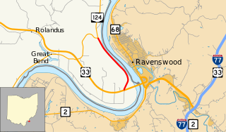
State Route 338 was a state highway in the southeastern portion of the U.S. state of Ohio, entirely in Meigs County. Running along the Ohio River, the route existed from 1932 until about 2012. For most of its history, SR 338 ran along the river between Racine and Lebanon Township with both ends at SR 124. At the time of its removal from the state highway system, the last remnant of the route was a 2.3-mile-long (3.7 km) segment between US 33 near the Ravenswood Bridge and SR 124.

Lebanon Township, Meigs County, Ohio Township in Ohio, United States

Lebanon Township is one of the twelve townships of Meigs County, Ohio, United States. The 2000 census found 1,029 people in the township.

Letart Township, Meigs County, Ohio Township in Ohio, United States

Letart Township is one of the twelve townships of Meigs County, Ohio, USA. The 2000 census found 641 people in the township.

Sutton Township, Meigs County, Ohio Township in Ohio, United States

Sutton Township is one of the twelve townships of Meigs County, Ohio, United States. The 2000 census found 3,250 people in the township, 1,625 of whom lived in the unincorporated portions of the township.

Chester, Ohio human settlement in Ohio, United States of America

Chester is an unincorporated community in central Chester Township, Meigs County, Ohio, United States. It lies along the Shade River at the intersection of State Routes 7 and 248. Although it is unincorporated, it has a post office, with the ZIP code of 45720.

Buckeye, El Dorado County, California Unincorporated community in California, United States

Buckeye is an unincorporated community in El Dorado County, California. It is located 2.5 miles (4.0 km) east-northeast of Georgetown, at an elevation of 2949 feet.

Antiquity is an unincorporated community in Meigs County, in the U.S. state of Ohio.

Carletonville is an unincorporated community in Meigs County, in the U.S. state of Ohio.

Kingsbury is an unincorporated community in Meigs County, in the U.S. state of Ohio.

Silver Run is an unincorporated community in Meigs County, in the U.S. state of Ohio.

Spiller is an unincorporated community in Meigs County, in the U.S. state of Ohio.

Success is an unincorporated community in Meigs County, in the U.S. state of Ohio.

Welsh is an unincorporated community in Meigs County, in the U.S. state of Ohio.

Honey Creek is a stream in the U.S. state of Ohio.

Meigs Creek is a stream in the U.S. state of Ohio. It is a tributary of the Muskingum River.

West Newton is an unincorporated community in Allen County, in the U.S. state of Ohio.

Flora is an extinct town in Meigs County, in the U.S. state of Ohio. The GNIS classifies it as a populated place.

Meigs is an unincorporated community in Morgan County, in the U.S. state of Ohio.

References

  1. U.S. Geological Survey Geographic Names Information System: Letart Falls, Ohio
  2. "Meigs County". Jim Forte Postal History. Retrieved 12 December 2015.
  3. Larkin, Stillman Carter (1908). The Pioneer History of Meigs County. Berlin Printing Company. p. 157.

Coordinates: 38°53′34″N81°55′26″W / 38.89278°N 81.92389°W / 38.89278; -81.92389

Geographic coordinate system Coordinate system

A geographic coordinate system is a coordinate system that enables every location on Earth to be specified by a set of numbers, letters or symbols. The coordinates are often chosen such that one of the numbers represents a vertical position and two or three of the numbers represent a horizontal position; alternatively, a geographic position may be expressed in a combined three-dimensional Cartesian vector. A common choice of coordinates is latitude, longitude and elevation. To specify a location on a plane requires a map projection.