
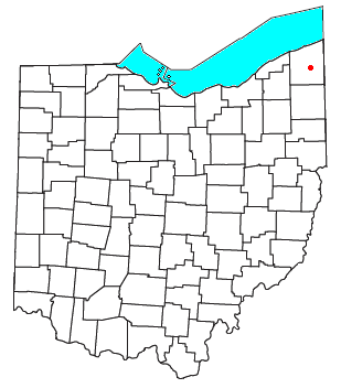
Ashtabula County is the northeasternmost county in the U.S. state of Ohio. As of the 2020 census, the population was 97,574. The county seat is Jefferson, while its largest city is Ashtabula. The county was created in 1808 and later organized in 1811. The name Ashtabula derives from the Lenape language phrase ashte-pihële, which translates to 'always enough (fish) to go around, to be given away' and is a contraction of apchi ('always') + tepi ('enough') + hële. Ashtabula County is part of the Cleveland, OH Metropolitan Statistical Area.

The Grand River is a tributary of Lake Erie, 102.7 miles (165.3 km) long, in northeastern Ohio in the United States. Via Lake Erie, the Niagara River and Lake Ontario, it is part of the watershed of the St. Lawrence River, which flows to the Atlantic Ocean. It drains an area of 712 mi² (1844 km²).

Hartford is an unincorporated community in central Hartford Township, Trumbull County, Ohio, United States. It has a post office with the ZIP code 44424. It lies at the intersection of State Routes 7 and 305.

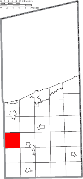
Rome Township is one of the twenty-seven townships of Ashtabula County, Ohio, United States. The 2020 census found 1,854 people in the township.

Madison Township is one of the five townships of Lake County, Ohio, United States. As of the 2020 census the population was 18,492. It is the largest township in Ohio by area.
Trumbull Township is one of the twenty-seven townships of Ashtabula County, Ohio, United States. The 2020 census found 1,376 people in the township.

Pierpont is an unincorporated community in central Pierpont Township, Ashtabula County, Ohio, United States. It has a post office with the ZIP code 44082. Served by Area Code 440 Exchange 577. Pierpont is at the intersection of State Routes 7 and 167.
Dorset is an unincorporated community in central Dorset Township, Ashtabula County, Ohio, United States. It has a post office with the ZIP code 44032. It lies along State Route 193.

Fowler is an unincorporated community in central Fowler Township, Trumbull County, Ohio, United States. It has a post office with the ZIP code 44418. It lies at the intersection of State Routes 193 and 305.

Burghill is an unincorporated community in southern Vernon Township, Trumbull County, Ohio, United States. It is unincorporated although it had a post office, with the ZIP code of 44404 until 2011. It lies along State Route 7 north of Hubbard. The community is part of the Youngstown–Warren–Boardman, OH-PA Metropolitan Statistical Area.
Mecca is an unincorporated community in Trumbull County, in the U.S. state of Ohio.
Sodom is an unincorporated community in Trumbull County, Ohio, United States.
Eagleville is an unincorporated community in Ashtabula County, in the U.S. state of Ohio.
Ohltown is an unincorporated community in Mahoning County, in the U.S. state of Ohio. It is a suburb located between Youngstown, Austintown, and the Meander Creek Reservoir.
Delightful is an unincorporated community in Trumbull County, in the U.S. state of Ohio.
Griggs Corners is an unincorporated community in Ashtabula County, in the U.S. state of Ohio.
Phalanx is an unincorporated community in Braceville Township, Trumbull County, Ohio, United States. It is identified by signage as Phalanx Mills.

Pricetown is an unincorporated community in Mahoning and Trumbull counties, in the U.S. state of Ohio.
Stanhope is an unincorporated community in Ashtabula and Trumbull counties, in the U.S. state of Ohio.

Wick is an unincorporated community in Ashtabula County, in the U.S. state of Ohio.

