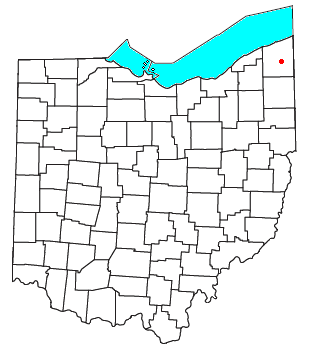
Geauga County is a county in the U.S. state of Ohio. As of the 2020 census, the population was 95,397. The county seat and largest city is Chardon.

The Cleveland metropolitan area, or Greater Cleveland as it is more commonly known, is the metropolitan area surrounding the city of Cleveland in Northeast Ohio, United States. According to the 2020 census results, the six-county Cleveland, OH Metropolitan Statistical Area (MSA) consists of Cuyahoga County, Ashtabula County, Geauga County, Lake County, Lorain County, and Medina County, and has a population of 2,185,825, making it the 33rd-most populous metropolitan area in the United States and the third largest metropolitan area in Ohio. The metro area is also part of the larger Cleveland–Akron–Canton Combined Statistical Area with a population of over 3.7 million people, the most populous statistical area in Ohio and the 17th most populous in the United States.

The region Northeast Ohio, in the US state of Ohio, in its most expansive usage contains six metropolitan statistical areas: Cleveland–Elyria, Akron, Canton–Massillon, Youngstown–Warren, Mansfield, and Weirton–Steubenville along with eight micropolitan statistical areas. Most of the region is considered either part of the Cleveland–Akron–Canton, OH Combined Statistical Area and media market or the Youngstown–Warren, OH–PA Combined Statistical Area and media market. In all, the region is home to: 4,502,460 residents. It is also a part of the Great Lakes megalopolis, containing over 54 million people. Northeast Ohio also includes most of the area known historically as the Connecticut Western Reserve.

Madison Township is one of the five townships of Lake County, Ohio, United States. As of the 2020 census the population was 18,492. It is the largest township in Ohio by area.

Harpersfield Township is one of the twenty-seven townships of Ashtabula County, Ohio, United States. The 2020 census found 2,591 people in the township.

Cuba is an unincorporated community in western Washington Township, Clinton County, Ohio, United States. It has a post office with the ZIP code 45114. It lies at the intersection of U.S. Route 68 with State Route 350. In addition to the post office, the community is home to the Cuba Friends Meeting, a part of the Wilmington Yearly Meeting of the Society of Friends.

Blue Creek is an unincorporated community in western Jefferson Township, Adams County, Ohio, United States. It is located along State Route 125. It has a post office with the ZIP code 45616.

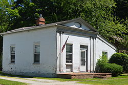
Williamsfield is an unincorporated community in central Williamsfield Township, Ashtabula County, Ohio, United States. It has a post office with the ZIP code 44093. It lies at the intersection of U.S. Route 322 with State Route 7. In 2014, it was named the most stressed community in the United States.

Pierpont is an unincorporated community in central Pierpont Township, Ashtabula County, Ohio, United States. It has a post office with the ZIP code 44082. Served by Area Code 440 Exchange 577. Pierpont is at the intersection of State Routes 7 and 167.
Dorset is an unincorporated community in central Dorset Township, Ashtabula County, Ohio, United States. It has a post office with the ZIP code 44032. It lies along State Route 193.

Ray is an unincorporated community in southeastern Harrison Township, Vinton County, Ohio, United States. It has a post office with the ZIP code 45672. It is located along State Route 327 in western Vinton County.
Robertsville is an unincorporated community and census-designated place in western Paris Township, Stark County, Ohio, United States. It has a post office with the ZIP code 44670. It lies along U.S. Route 30 between East Canton and Minerva and is in the Minerva Local School District. The community is part of the Canton–Massillon Metropolitan Statistical Area. The population was 293 at the 2020 census.

Scioto Furnace is an unincorporated community in western Bloom Township, Scioto County, Ohio, United States. It has a post office with the ZIP code 45677. It lies along State Route 140.

Wingett Run is an unincorporated community in western Ludlow Township, Washington County, Ohio, United States. It has a post office with the ZIP code 45789. It is located along State Route 26 and the Little Muskingum River.

Nashport is an unincorporated community and Census-designated place in western Licking Township, Muskingum County, Ohio, United States. It has a post office with the ZIP code 43830. It lies along State Route 146.

Chandlersville is an unincorporated community in western Salt Creek Township, Muskingum County, Ohio, United States. It has a post office with the ZIP code 43727. It lies along State Route 146 at its intersection with State Routes 284 and 313.

Blue Rock is an unincorporated community in western Blue Rock Township, Muskingum County, Ohio, United States. It is a part of the Franklin Local School District. Blue Rock State Park is located within Blue Rock, Ohio.

Moline is an unincorporated community in western Lake Township, Wood County, Ohio, United States.
Fitchville is an unincorporated community in Fitchville Township, Huron County, Ohio, United States. It is part of the Norwalk Micropolitan Statistical Area. Fitchville is located at the intersection of U.S. Route 250, State Route 13, and State Route 162. The community has no post office of its own and is assigned the New London zip code of 44851. The Mansion Hotel was a prominent Fitchville landmark for one hundred and thirty years from 1839 to 1968. It was reputed to have hosted Abraham Lincoln, and served as an overnight resting place for many escaping slaves travelling on the "underground railroad".
Unionville is a suburban community in the Delaware Valley located on Pennsylvania Route 309. It is mainly in Hatfield Township, Montgomery County but also in Hilltown Township, Bucks County, Pennsylvania, United States.