
Arthur St. Clair was a Scottish-American soldier and politician. Born in Thurso, Scotland, he served in the British Army during the French and Indian War before settling in Pennsylvania, where he held local office. During the American Revolutionary War, he rose to the rank of major general in the Continental Army, but lost his command after a controversial retreat from Fort Ticonderoga.

Columbus is the capital and most populous city of the U.S. state of Ohio. With a 2020 census population of 905,748, it is the 14th-most populous city in the U.S., the second-most populous city in the Midwest after Chicago, and the third-most populous U.S. state capital after Phoenix, Arizona and Austin, Texas. Columbus is the county seat of Franklin County; it also extends into Delaware and Fairfield counties. It is the core city of the Columbus metropolitan area, which encompasses ten counties in central Ohio. It had a population of 2,138,926 in 2020, making it the largest metropolitan area entirely in Ohio and 14th-largest city in the U.S.

Ohio is a state in the Midwestern United States. Of the fifty U.S. states, it is the 34th-largest by area. With a population of nearly 11.8 million, Ohio is the seventh-most populous and tenth-most densely populated state. Its capital and largest city is Columbus, with other large population centers including Cleveland, Cincinnati, Dayton, Akron, and Toledo. Ohio is bordered by Lake Erie to the north, Pennsylvania to the east, West Virginia to the southeast, Kentucky to the southwest, Indiana to the west, and Michigan to the northwest. Ohio is nicknamed the "Buckeye State" after its Ohio buckeye trees, and Ohioans are also known as "Buckeyes". Its state flag is the only non-rectangular flag of all the U.S. states.

The Ohio River is a 981-mile (1,579 km) long river in the United States. It is located at the boundary of the Midwestern and Southern United States, flowing in a southwesterly direction from western Pennsylvania to its mouth on the Mississippi River at the southern tip of Illinois. It is the third largest river by discharge volume in the United States and the largest tributary by volume of the north-south flowing Mississippi River that divides the eastern from western United States. It is also the 6th oldest river on the North American continent. The river flows through or along the border of six states, and its drainage basin includes parts of 14 states. Through its largest tributary, the Tennessee River, the basin includes several states of the southeastern U.S. It is the source of drinking water for five million people.

Ashtabula County is the northeasternmost county in the U.S. state of Ohio. As of the 2020 census, the population was 97,574. The county seat is Jefferson, while its largest city is Ashtabula. The county was created in 1808 and later organized in 1811. The name Ashtabula derives from the Lenape language phrase ashte-pihële, which translates to 'always enough (fish) to go around, to be given away' and is a contraction of apchi ('always') + tepi ('enough') + hële. Ashtabula County comprises the Ashtabula, OH Micropolitan Statistical Area, which is also included in the Cleveland–Akron–Canton, OH Combined Statistical Area.

The Midwestern United States, also referred to as the Midwest or the American Midwest, is one of four census regions of the United States Census Bureau. It occupies the northern central part of the United States. It was officially named the North Central Region by the U.S. Census Bureau until 1984. It is between the Northeastern United States and the Western United States, with Canada to the north and the Southern United States to the south.

Kentwood is a city in Kent County in the U.S. state of Michigan. The population was 54,304 as of the 2020 census. The city is bordered on the northwest by Grand Rapids and is the third most-populated municipality in the Grand Rapids metropolitan area.

Marietta is a city in, and the county seat of, Washington County, Ohio, United States. It is located in southeastern Ohio at the confluence of the Muskingum and Ohio Rivers, 11 miles (18 km) northeast of Parkersburg, West Virginia. As of the 2020 census, Marietta has a population of 13,385 people. It is the principal city of the Marietta micropolitan area, which includes all of Washington County, and is the second-largest city in the Parkersburg–Marietta–Vienna combined statistical area.

The Northwest Territory, also known as the Old Northwest and formally known as the Territory Northwest of the River Ohio, was formed from unorganized western territory of the United States after the American Revolutionary War. Established in 1787 by the Congress of the Confederation through the Northwest Ordinance, it was the nation's first post-colonial organized incorporated territory.

The Cuyahoga River is a river located in Northeast Ohio that bisects the City of Cleveland and feeds into Lake Erie.

Frank Bartlett Willis was an American politician and lawyer. He was a Republican from Ohio. He served as the 47th governor of Ohio from 1915 to 1917, then served as a U.S. Senator from Ohio from 1921 until his death in 1928.

Return Jonathan Meigs Jr. was a Democratic-Republican politician from Ohio. He served as the fourth governor of Ohio, fifth United States Postmaster General, and as a United States senator.

The Ohio and Erie Canal was a canal constructed during the 1820s and early 1830s in Ohio. It connected Akron with the Cuyahoga River near its outlet on Lake Erie in Cleveland, and a few years later, with the Ohio River near Portsmouth. It also had connections to other canal systems in Pennsylvania.
The Department of the Ohio was an administrative military district created by the United States War Department early in the American Civil War to administer the troops in the Northern states near the Ohio River.
Charles Kellogg was an American farmer, merchant and politician from New York. From 1825 to 1827, he served one term in the U.S. House of Representatives.

Kelloggsville Public Schools is a school district located in Grand Rapids, Michigan, Wyoming, Michigan, and Kentwood, Michigan. The district serves 2,289 students
Kelloggsville may refer to:
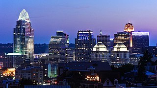
Cincinnati is a city in the U.S. state of Ohio and the county seat of Hamilton County. Settled in 1788, the city is located at the northern side of the confluence of the Licking and Ohio rivers, the latter of which marks the state line with Kentucky. The city is the economic and cultural hub of the Cincinnati metropolitan area. With an estimated population of 2,265,051, it is Ohio's largest metropolitan area and the nation's 30th-largest, and with a city population of 309,317, Cincinnati is the third-most populous city in Ohio after Columbus and Cleveland, and 65th in the United States. Throughout much of the 19th century, it was among the top 10 U.S. cities by population, surpassed only by New Orleans and the older, established settlements of the United States eastern seaboard, as well as being the sixth-most populous city from 1840 until 1860.
Kelloggsville is a hamlet in the town of Niles, Cayuga County, New York, United States.

