Fort St. James | |
---|---|
District of Fort St. James [1] | |
Coordinates: 54°26′35″N124°15′15″W / 54.44306°N 124.25417°W | |
Country | Canada |
Province | British Columbia |
Region | Omineca Country |
Regional district | Regional District of Bulkley Nechako |
Founded | 1806 |
Incorporated | 1952 |
Government | |
• Governing body | Municipal Council |
• Mayor | Martin Elphee |
Area | |
• Total | 23.47 km2 (9.06 sq mi) |
Elevation | 700 m (2,300 ft) |
Population (2016) | |
• Total | 1,598 |
• Density | 72.0/km2 (186/sq mi) |
Time zone | UTC−8 (PST) |
• Summer (DST) | UTC−7 (PDT) |
Postal code span | |
Area code(s) | +250, +778 |
Highways | 27 |
Waterways | Stuart Lake, Stuart River, Necoslie River, Nahounli Creek |
Website | www |
Official name | Fort St. James National Historic Site of Canada |
Designated | 1948 |
Fort St. James is a district municipality and former fur trading post in northern central British Columbia, Canada. It is located on the south-eastern shore of Stuart Lake in the Omineca Country, at the northern terminus of Highway 27, which connects to Highway 16 at Vanderhoof.
It is home to the John Prince Research Forest which features abundant wildlife. [2] This community celebrated its bicentennial in 2016 and is incorporated as a district municipality.
Founded by the North West Company explorer and fur trader Simon Fraser in 1806, it came under the management of the Hudson's Bay Company in 1821 with the forced merger of the two battling fur companies. Also known historically as Stuart Lake Post, it is one of British Columbia's oldest permanent European settlements and was the administrative centre for the Hudson's Bay Company's New Caledonia fur district. [3] The fort, rebuilt four times, continued as an important trading post well into the twentieth century. Now the fort is a National Historic Site of Canada [4] [5] with some buildings dating to the 1880s.
As part of his commission from the North West Company, Fraser and his assistants John Stuart and James McDougall explored potential river routes to the Pacific Ocean from 1805 through 1808. Explorations in the Winter of 1805-06 by McDougall resulted in the discovery of Carrier's Lake, now known as Stuart Lake. In the heart of territory inhabited by the Carrier or Dakelh First Nation, this proved to be a lucrative locale for fur trading and so a post – Fort St. James – was built on its shore in 1806. In 1821, the fort came under the control of the Hudson's Bay Company, when the North West Company merged with it. It subsequently became the administrative headquarters of the company's vast New Caledonia District.
The fur trade was slow to take root in the area, since the economy of the Dakelh people had been based on the fishery, rather than on trapping. In addition, there were customary and ceremonial restrictions which placed obstacles in the way of an efficient fur economy. Nonetheless, eventually the post became profitable, and continued to function until its closure in 1952.
The community is located on the south-eastern shore of Stuart Lake, at the head of the Stuart River. Both the lake and the river are named for Fraser's assistant John Stuart, who would later become head of the New Caledonia District of the North West Company.
Fort St. James is located in the sub-boreal spruce zone of British Columbia, a sub-division of the hemiboreal climatic zone. It is characterised by severe, snowy winters and short, warm summers. The region is rich in wildlife. Under the Köppen climate classification Fort St. James is classified as a humid continental climate (Dfb).
Climate data for Fort St. James, 1981–2010 normals, extremes 1895–present | |||||||||||||
---|---|---|---|---|---|---|---|---|---|---|---|---|---|
Month | Jan | Feb | Mar | Apr | May | Jun | Jul | Aug | Sep | Oct | Nov | Dec | Year |
Record high °C (°F) | 12.0 (53.6) | 13.0 (55.4) | 17.1 (62.8) | 24.4 (75.9) | 35.0 (95.0) | 33.9 (93.0) | 36.7 (98.1) | 35.6 (96.1) | 29.5 (85.1) | 26.5 (79.7) | 16.1 (61.0) | 11.0 (51.8) | 36.7 (98.1) |
Mean daily maximum °C (°F) | −5.3 (22.5) | −1.7 (28.9) | 4.0 (39.2) | 9.9 (49.8) | 15.6 (60.1) | 19.6 (67.3) | 21.8 (71.2) | 21.7 (71.1) | 16.4 (61.5) | 9.0 (48.2) | 0.6 (33.1) | −3.8 (25.2) | 9.0 (48.2) |
Daily mean °C (°F) | −9.5 (14.9) | −6.8 (19.8) | −1.8 (28.8) | 3.9 (39.0) | 9.2 (48.6) | 13.4 (56.1) | 15.4 (59.7) | 14.8 (58.6) | 10.2 (50.4) | 4.3 (39.7) | −3.0 (26.6) | −7.8 (18.0) | 3.5 (38.3) |
Mean daily minimum °C (°F) | −13.7 (7.3) | −11.8 (10.8) | −7.7 (18.1) | −2.2 (28.0) | 2.8 (37.0) | 7.2 (45.0) | 8.9 (48.0) | 7.9 (46.2) | 3.9 (39.0) | −0.5 (31.1) | −6.5 (20.3) | −11.7 (10.9) | −2.0 (28.4) |
Record low °C (°F) | −49.4 (−56.9) | −49.4 (−56.9) | −39.4 (−38.9) | −29.4 (−20.9) | −11.7 (10.9) | −6.1 (21.0) | −5.6 (21.9) | −7.8 (18.0) | −13.3 (8.1) | −23.0 (−9.4) | −37.8 (−36.0) | −47.2 (−53.0) | −49.4 (−56.9) |
Average precipitation mm (inches) | 48.1 (1.89) | 30.0 (1.18) | 25.7 (1.01) | 23.7 (0.93) | 38.9 (1.53) | 50.6 (1.99) | 50.6 (1.99) | 45.0 (1.77) | 39.3 (1.55) | 48.1 (1.89) | 44.5 (1.75) | 42.6 (1.68) | 487.2 (19.18) |
Average rainfall mm (inches) | 4.9 (0.19) | 3.6 (0.14) | 5.9 (0.23) | 18.0 (0.71) | 38.2 (1.50) | 50.6 (1.99) | 50.6 (1.99) | 45.0 (1.77) | 39.1 (1.54) | 38.7 (1.52) | 15.7 (0.62) | 4.2 (0.17) | 314.5 (12.38) |
Average snowfall cm (inches) | 43.3 (17.0) | 26.4 (10.4) | 19.8 (7.8) | 5.7 (2.2) | 0.7 (0.3) | 0 (0) | 0 (0) | 0 (0) | 0.2 (0.1) | 9.5 (3.7) | 28.8 (11.3) | 38.4 (15.1) | 172.7 (68.0) |
Average precipitation days (≥ 0.2 mm) | 12.7 | 8.9 | 8.6 | 8.3 | 12.4 | 12.7 | 13.7 | 11.3 | 12.1 | 14.0 | 13.1 | 11.3 | 139.1 |
Average rainy days (≥ 0.2 mm) | 2.0 | 1.8 | 3.2 | 6.8 | 12.2 | 12.7 | 13.7 | 11.3 | 12.1 | 12.4 | 5.3 | 1.8 | 95.2 |
Average snowy days (≥ 0.2 cm) | 11.4 | 7.4 | 6.0 | 2.2 | 0.4 | 0 | 0 | 0 | 0.08 | 2.4 | 9.0 | 10.0 | 48.8 |
Average relative humidity (%) | 81.6 | 72.6 | 57.0 | 45.0 | 44.1 | 48.0 | 47.3 | 47.7 | 52.7 | 62.9 | 79.8 | 84.2 | 60.2 |
Mean monthly sunshine hours | 51.3 | 85.5 | 151.3 | 207.6 | 245.7 | 260.2 | 275.3 | 256.8 | 177.7 | 116.0 | 60.2 | 41.0 | 1,928.6 |
Percent possible sunshine | 20.8 | 31.3 | 41.3 | 49.3 | 49.5 | 50.6 | 53.4 | 55.6 | 46.4 | 35.4 | 23.5 | 17.9 | 39.6 |
Source: Environment Canada, [6] [7] [8] (Sunshine and humidity data from Fort St. James Airport) |
In the 2021 Census of Population conducted by Statistics Canada, Fort St. James had a population of 1,386 living in 586 of its 671 total private dwellings, a change of -13.3% from its 2016 population of 1,598. With a land area of 23.45 km2 (9.05 sq mi), it had a population density of 59.1/km2 (153.1/sq mi) in 2021. [9]
About one quarter of the population of the greater Fort St. James area identify as being of First Nations origin [10] The town is surrounded by numerous, small First Nations communities and Indian reserves, including Pinchie, Tachie, and Nak'azdli.
Throughout the 1980s and 1990s, Fort St. James had the highest proportion of South Asians of any municipality in Canada, forming approximately 22% of the total population as per the 1991 census. [11] The South Asian community of Fort St. James was composed mostly of Punjabis of the Sikh faith. Gursikh Temple, the local gurdwara, was built in 1981. The Sikh population of Fort St. James declined from 435 in 1991 (21.6% of the municipality's 2,015 residents) [12] to 20 in 2021 (1.5% of the municipality's 1,330 residents), [13] as many Sikhs moved to Greater Vancouver. [14] The Gursikh Temple was donated to the Victory Christian Church in 2013. [15] [14]
Panethnic group | 2021 [16] | 2016 [17] | 2011 [18] | 2006 [19] | 2001 [20] | 1996 [21] | 1991 [22] [23] | 1986 [24] [25] [26] : 98 | 1981 [27] | |||||||||
---|---|---|---|---|---|---|---|---|---|---|---|---|---|---|---|---|---|---|
Pop. | % | Pop. | % | Pop. | % | Pop. | % | Pop. | % | Pop. | % | Pop. | % | Pop. | % | Pop. | % | |
European [lower-alpha 1] | 925 | 69.55% | 890 | 56.33% | 1,055 | 64.53% | 990 | 73.06% | 1,195 | 62.08% | 1,320 | 64.55% | 1,225 | 60.79% | 1,185 | 59.85% | 1,390 | 62.19% |
Indigenous | 300 | 22.56% | 555 | 35.13% | 445 | 27.22% | 160 | 11.81% | 500 | 25.97% | 295 | 14.43% | 265 | 13.15% | 425 | 21.46% | 455 | 20.36% |
South Asian | 25 | 1.88% | 60 | 3.8% | 75 | 4.59% | 165 | 12.18% | 200 | 10.39% | 405 | 19.8% | 435 | 21.59% | 335 | 16.92% | 345 | 15.44% |
Other [lower-alpha 2] | 35 | 2.63% | 85 | 5.38% | 50 | 3.06% | 40 | 2.95% | 30 | 1.56% | 25 | 1.22% | 90 | 4.47% | 35 | 1.77% | 45 | 2.01% |
Total responses | 1,330 | 95.96% | 1,580 | 98.87% | 1,635 | 96.69% | 1,355 | 100% | 1,925 | 99.9% | 2,045 | 99.95% | 2,015 | 97.91% | 1,980 | 99.85% | 2,235 | 97.85% |
Total population | 1,386 | 100% | 1,598 | 100% | 1,691 | 100% | 1,355 | 100% | 1,927 | 100% | 2,046 | 100% | 2,058 | 100% | 1,983 | 100% | 2,284 | 100% |
Religious group | 2021 [16] | 2011 [18] | 2001 [20] | 1991 [22] | ||||
---|---|---|---|---|---|---|---|---|
Pop. | % | Pop. | % | Pop. | % | Pop. | % | |
Christian | 395 | 29.7% | 775 | 47.55% | 970 | 50.39% | 1,065 | 52.85% |
Sikh | 20 | 1.5% | 50 | 3.07% | 200 | 10.39% | 435 | 21.59% |
Muslim | 20 | 1.5% | 0 | 0% | 0 | 0% | 0 | 0% |
Buddhist | 10 | 0.75% | 0 | 0% | 10 | 0.52% | 0 | 0% |
Hindu | 0 | 0% | 0 | 0% | 0 | 0% | 0 | 0% |
Jewish | 0 | 0% | 0 | 0% | 0 | 0% | 0 | 0% |
Other religion | 20 | 1.5% | 55 | 3.37% | 0 | 0% | 0 | 0% |
Irreligious | 855 | 64.29% | 755 | 46.32% | 760 | 39.48% | 510 | 25.31% |
Total responses | 1,330 | 95.96% | 1,630 | 96.39% | 1,925 | 99.9% | 2,015 | 97.91% |
The Township of Esquimalt is a municipality at the southern tip of Vancouver Island, in British Columbia, Canada. It is bordered to the east by the provincial capital, Victoria, to the south by the Strait of Juan de Fuca, to the west by Esquimalt Harbour and Royal Roads, to the northwest by the New Songhees 1A Indian reserve and the town of View Royal, and to the north by a narrow inlet of water called the Gorge, across which is the district municipality of Saanich. It is almost tangential to Esquimalt 1 Indian Reserve near Admirals Road. It is one of the 13 municipalities of Greater Victoria and part of the Capital Regional District.
Sparwood is a district municipality in the Canadian province of British Columbia. It is the second-largest community on the Elk River.
The Squamish-Lillooet Regional District is a quasi-municipal administrative area in British Columbia, Canada. It stretches from Britannia Beach in the south to Pavilion in the north. Lillooet, Pemberton, Whistler and Squamish are the four municipalities in the regional district. Its administrative offices are in the Village of Pemberton, although the district municipalities of Squamish and Whistler are larger population centres. The district covers 16,353.68 km² of land area.
Duncan is a city on southern Vancouver Island in British Columbia, Canada. It is the smallest city by area in Canada. It was incorporated in 1912.
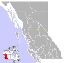
The Regional District of Bulkley–Nechako (RDBN) is a regional district in the Canadian province of British Columbia, Canada. As of the 2021 census, the population was 37,737. The area is 73,419.01 square kilometres. The regional district offices are in Burns Lake.
North Cowichan is a district municipality established in 1873 on Vancouver Island, in British Columbia, Canada. The municipality is part of the Cowichan Valley Regional District. North Cowichan is noted for a landscape including forests, beaches, rivers, and lakes. The municipality encompasses the communities of Chemainus; Westholme; Crofton; Maple Bay; and "the South End". The latter is an informal name for a built-up area which is essentially a suburb of the City of Duncan, a separate municipality.
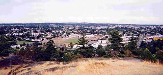
Williams Lake is a city in the Central Interior of British Columbia, in the central part of a region known as the Cariboo. Williams Lake is one of the largest cites, by population of metropolitan area, in the Cariboo after neighbouring Quesnel. The city is famous for the Williams Lake Stampede, which was once the second largest professional rodeo in Canada, after only the Calgary Stampede.
The District of Metchosin is a municipality and community in Greater Victoria on the southern tip of Vancouver Island in British Columbia, Canada. It is a coastal community adjacent to the Strait of Juan de Fuca. Metchosin is part of the Western Communities and one of the 13 regional municipalities.
The Cowichan Valley Regional District is a regional district in the Canadian province of British Columbia is on the southern part of Vancouver Island, bordered by the Nanaimo and Alberni-Clayoquot Regional Districts to the north and northwest, and by the Capital Regional District to the south and east. As of the 2021 Census, the Regional District had a population of 89,013. The regional district offices are in Duncan.
The Cariboo Regional District spans the Cities and Districts of Quesnel, Williams Lake, 100 Mile House, and Wells in the Central Interior of British Columbia.
Lac La Biche is a hamlet in Lac La Biche County within northeast Alberta, Canada. It is located approximately 220 km (140 mi) northeast of the provincial capital of Edmonton. Previously incorporated as a town, Lac La Biche amalgamated with Lakeland County to form Lac La Biche County on August 1, 2007.
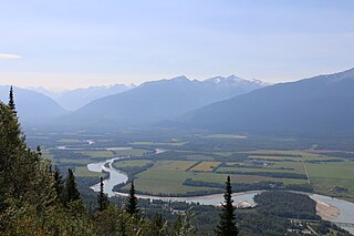
Vanderhoof is a district municipality near the geographical centre of British Columbia, Canada. Covering 2.92 square kilometers, it has a population of about 4,500 within town limits, and offers services to nearly 10,000 people in nearby rural communities. Its main industries are forestry, agriculture, and related businesses. Tourism is also growing, and mining operations are being developed in the area. It has many elementary schools, and one major secondary school, Nechako Valley Secondary School (NVSS), comprising School District 91 Nechako Lakes. The College of New Caledonia has a regional campus there.
Mackenzie is a district municipality within the Fraser-Fort George Regional District in central British Columbia, Canada. The community is located at the south end of Williston Lake. The townsite, established by Alexandra Forest Industries and Cattermole Timber, was named for Sir Alexander MacKenzie (1764–1820).
Port Hardy is a district municipality in British Columbia, Canada located on the north-east end of Vancouver Island. Port Hardy has a population of 3,902 as of the 2021 census.
The Northern Rockies Regional Municipality (NRRM), formerly the Northern Rockies Regional District (NRRD), and before that the Fort Nelson–Liard Regional District, is a municipality in northeastern British Columbia, Canada. Although portrayed as a regional municipality in its official name, and existing on the same administrative level as a regional district, it is actually classified as a district municipality. The NRRM's offices are located in Fort Nelson, formerly an incorporated town that amalgamated with the NRRD on February 6, 2009 to form the NRRM. With the Peace River Regional District as the southern part, it was the northern part of the Peace River-Liard Regional District, which was split into two on October 31, 1987.
The Regional District of Kitimat–Stikine is a local government administration in northwestern British Columbia, Canada. As of the 2016 Canadian census, it had a population of 37,367 living on a land area of 104,464.61 square kilometres (40,334.01 sq mi). Its administrative offices are in the city of Terrace. The next-largest municipality in the regional district is the District Municipality of Kitimat. The other incorporated municipalities in the regional district are the Village of Hazelton, the District of New Hazelton and the District of Stewart. Unincorporated communities are many, most of them Indian Reserves which are not part of the governmental system of the regional district, which has limited powers relating mostly to municipal-type services. The remote settlement of Dease Lake, formerly in the Stikine Region, was added to the regional district on December 1, 2007. Thornhill is the largest unincorporated community in the regional District with a population of 5000+ residents.
The Regional District of Fraser–Fort George (RDFFG) is a regional district located in the Central Interior of British Columbia, Canada. It is bounded by the Alberta border to the east, the Columbia–Shuswap and Thompson–Nicola regional districts to the south and southeast, Cariboo Regional District to the southwest, the Regional District of Bulkley–Nechako to the west, and the Peace River Regional District to the north and northeast. As of the Canada 2011 Census, Fraser–Fort George had a population of 91,879 and a land area of 51,083.73 km2. The offices of the regional district are located at Prince George.
The demographics of Metro Vancouver indicate a multicultural and multiracial region. Metro Vancouver is a metropolitan area, with its major urban centre being Vancouver, British Columbia, Canada. The Vancouver census metropolitan area, as defined by Statistics Canada, encompasses roughly the same territory as the Metro Vancouver Regional District, a regional district in British Columbia. The regional district includes 23 local authorities. Figures provided here are for the Vancouver census metropolitan area and not for the City of Vancouver.
Division No. 3 is one of eighteen census divisions in the province of Saskatchewan, Canada, as defined by Statistics Canada. It is located in the south-southwestern part of the province, adjacent to the border with Montana, United States. The most populous community in this division is Assiniboia.
Lake Cowichan is a town located on the east end of Cowichan Lake and, by highway, is 27 kilometres (17 mi) west of Duncan, British Columbia. The town of Lake Cowichan was incorporated in 1944. The Cowichan River flows through the middle of the town. Cowichan River is designated as a Heritage River.