
Burnaby is a city in the Lower Mainland region of British Columbia, Canada. Located in the centre of the Burrard Peninsula, it neighbours the City of Vancouver to the west, the District of North Vancouver across the confluence of the Burrard Inlet with its Indian Arm to the north, Port Moody and Coquitlam to the east, New Westminster and Surrey across the Fraser River to the southeast, and Richmond on the Lulu Island to the southwest.

New Westminster is a city in the Lower Mainland region of British Columbia, Canada, and a member municipality of the Metro Vancouver Regional District. It was founded by Major-General Richard Moody as the capital of the Colony of British Columbia in 1858 and continued in that role until the Mainland and Island colonies were merged in 1866. It was the British Columbia Mainland's largest city from that year until it was passed in population by Vancouver during the first decade of the 20th century.
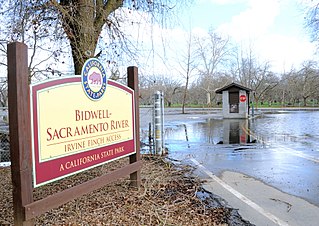
Bidwell–Sacramento River State Park is a state park of California, United States, preserving riparian habitat on the Sacramento River and its tributary Big Chico Creek. The park is located on the border of Butte County and Glenn County. Common activities include fishing for salmon, steelhead and shad; and floating the river on inner tubes, canoes or kayaks. The 349-acre (141 ha) property was established as a state park in 1979.

The Burrard Peninsula is a peninsula in the Lower Mainland region of British Columbia, Canada, bounded by the Burrard Inlet to the north, the Georgia Strait to the west, the North Arm of Fraser River to the south, and the Pitt River and Douglas Island to the east. The City of Vancouver occupies almost all of the western half of the peninsula, and the Cities of Burnaby and New Westminster occupy more than half of the eastern half. At its northeastern end, the peninsula is connected to the Eagle Mountain and Mount Burke of the Coast Mountains via a small isthmus at the center of the Tri-Cities.

Fish Creek Park is an urban provincial park that preserves the valley of Fish Creek in the southern part of Calgary, Alberta, Canada. It is bordered on three sides by the city, and on the west by the territory of the Tsuu T’ina Nation (Sarcee), a First Nation.

The City of Enderby is in the North Okanagan region of the Canadian province of British Columbia, between Armstrong and Salmon Arm. It is approximately 80 km north of Kelowna and 130 km east of Kamloops. Highway 97A passes through Enderby and the Shuswap River marks the eastern and northeastern limits of the City. There are two major schools in Enderby: M.V. Beattie Elementary School and A.L. Fortune Secondary School. M.V. Beattie Elementary School was rebuilt in 2012.

Bowron Lake Provincial Park is a wilderness provincial park located in east-central British Columbia, Canada, near the border with Alberta. It is 117 km (73 mi) east of the city of Quesnel. Other nearby towns include Wells and the historic destination of Barkerville. Once a popular hunting and fishing destination, today the park is protected and known for its abundant wildlife, rugged glaciated mountains, and freshwater lakes.

Vancouver Lake is located just west of Vancouver, Washington, United States, north of the Columbia River and Portland, Oregon, south of Ridgefield, Washington, and the Ridgefield National Wildlife Refuge.

The Colony of British Columbia was a crown colony in British North America from 1858 until 1866 that was founded by Richard Clement Moody, who was selected to 'found a second England on the shores of the Pacific', who was Chief Commissioner of Lands and Works for British Columbia and the first Lieutenant-Governor of British Columbia. Prior to the arrival of Moody's Royal Engineers, Columbia Detachment, the Colony's supreme authority was its Governor James Douglas, who was the Governor of the neighbouring colony of Vancouver Island.
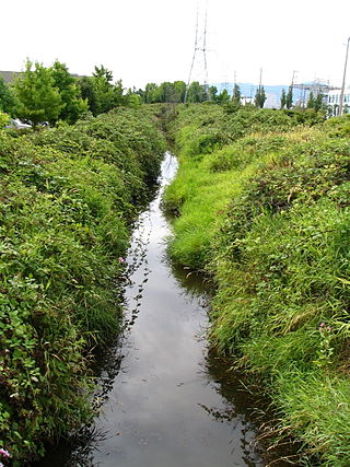
Still Creek is a long stream flowing across Central Burnaby, British Columbia and into Burnaby Lake. Still Creek's path lies mainly through the industrial area which contributes to its high level of pollution, although through dedicated work of local volunteers the creek is slowly recovering.
The Brunette River runs through East Burnaby, New Westminster and Coquitlam, flowing out of Burnaby Lake and to the Fraser River. It is the final outflow of the Central Valley Watershed, which consists of most streams between the Ulksen and Burnaby Heights. According to a map and materials by Heritage Advisory Committee and Environment and Waste Management Committee of the City of Burnaby (1993), the number of native campsites discovered on the shores of the Fraser River, Burrard Inlet and Deer Lake and some petroglyphs suggest that the area was used extensively by local aboriginal peoples such as the Squamish, Musqueam and Kwantlen for hunting and fishing before the arrival of European settlers.
The BC Games Society is a provincial crown corporation in British Columbia created in 1977. The organization is the governing body responsible for the BC Summer Games and BC Winter Games, and manages the Team BC program at the Canada Games. Ron Butlin served as the first manager-director of the society from 1977 to 1987.
The Columbia Detachment of the Royal Engineers was a contingent of the Royal Engineers of the British Army that was responsible for the foundation of British Columbia as the Colony of British Columbia (1858–66). It was commanded by Colonel Richard Clement Moody, FICE FRGS RIBA, Kt. (France).
An electoral redistribution was undertaken in 2008 in British Columbia in a process that began in late 2005 and was completed with the passage of the Electoral Districts Act, 2008 on April 10, 2008. The redistribution modified most electoral boundaries in the province and increased the number of MLAs from 79 to 85. The electoral boundaries created by the redistribution were first used in the 2009 provincial election.

Azure Lake is a fjord-like lake located in east-central British Columbia, Canada. It is an expansion of the Azure River which rises from an unnamed glacier in the Cariboo Mountains. The outflow is also called the Azure River, but it is only 50 m (164 ft) long before it flows into the Clearwater River. Azure Lake is one of the six major lakes in Wells Gray Provincial Park.
The Burnaby Lake Rowing Club (BLRC) is a rowing club located at Burnaby Lake in the City of Burnaby, British Columbia, Canada.
An electoral redistribution in British Columbia was undertaken by the BC Electoral Boundaries Commission beginning in 2014 and was formalized by the passage of Bill 42, the 2015 Electoral Districts Act, during the 40th British Columbia Parliament. The act came into effect on November 17, 2015. The redistribution added two seats to the previous total, increasing the number of MLAs in the province from 85 to 87. The electoral boundaries came into effect for the 2017 election. The next redistribution is required to occur following the 2020 British Columbia general election.
An electoral redistribution in British Columbia is underway by the BC Electoral Boundaries Commission. On October 21, 2021, the Government of British Columbia appointed Justice Nitya Iyer, Linda Tynan and Chief Electoral Officer Anton Boegman to serve as the 2021 commissioners. Justice Iyer was appointed the chair.

